Viroconium
Viroconium or Viroconium Cornoviorum was a Roman city in Britain . It was the main place of the civitas Cornoviorum ( Kornen ). The ancient place has not been built over and has been partially excavated. It is located in what is now the village of Wroxeter in Shropshire , England, after which the ancient city is also often named.
history
Around 45 AD, a cohort camp was built about 300 m south of the later city , in which Thracians were housed. Around 60 AD a legionary camp was built on the site of the later city, in which the Legio XIIII Gemina was housed. At 67 she was replaced by the Legio XX Valeria Victrix . This withdrew at the end of the first century and the place developed into a city. The settlement was initially rather small, but was expanded around the year 120. She received a regular, chessboard-like city map. In the west of the city an insula was occupied by a forum. It consisted of a large open space adorned with colonnades. In the west, on one of the short sides of the building, there was a basilica . She was 52 meters long with a 11.6 wide central aisle and 4.6 m wide aisles. There were six or seven rooms on the west side. When the basilica burned down in the middle of the second century, the contents of the northernmost room were not saved. Iron locks and iron parts of chests were found, an inkwell, three Trajan coins and a certificate of discharge dated April 14, 135, which belonged to an auxiliary soldier. Obviously, this was an official's office that kept Civitas records. Other rooms were on the east side of the basilica. The forum stood on the site of an unfinished bathhouse. It burned down between 165 and 185 but was rebuilt.
A classical-style temple stood next to the forum. It had six pillars at the front and was located within a 17 × 33 m area.
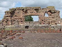
There was a large bathing complex in the neighboring insula. The main building was 73 × 19.8 m in size. To the north there was a palaestra that appeared to have a roof. There are indications that this was later used as a market hall. Weights were found during the excavations. The bathroom was once richly furnished and there is even evidence of wall mosaics. Parts of the walls are still standing today.
The city received water through an aqueduct that came in from the east and took water from Bell Brook . It was an open canal that was about a kilometer long.
Little is known of the former residential development. These buildings are mostly only known from aerial photographs. According to this, however, there were a number of large-scale city villas. Two temples are also only known from aerial photographs. The city had a wall surrounding it. At first it was earth walls that were raised at the end of the second century. A stone wall was later built on it.
The city was peacefully abandoned and fell into disrepair at the beginning of the eighth century.
literature
Overview works
- John Wacher: The Towns of Roman Britain. Routledge, London / New York 1997, ISBN 0-415-17041-9 , pp. 362-377.
Excavation reports
- Philip Barker among others: The Baths Basilica Wroxeter. Excavations 1966-90 (= Archaeological Report. Volume 8). English Heritage, London 1997, ISBN 1-850-74528-5 ( digitized ).
- John Chadderton (Ed.), Graham Webster: The Legionary Fortress at Wroxeter. Excavations by Graham Webster, 1955-85 (= Archaeological Report. Volume 19). English Heritage, London 2002, ISBN 1-850-74685-0 ( digitized ).
- Peter Ellis (Ed.): The Roman Baths and Macellum at Wroxeter. Excavations by Graham Webster, 1955-85 (= Archaeological Report. Volume 9). English Heritage, London 2000, ISBN 1-850-74606-0 ( digitized ).
Web links
Coordinates: 52 ° 40 ′ 34.7 " N , 2 ° 39 ′ 8.8" W.


