Durovernum Cantiacorum
Durovernum Cantiacorum was a Roman city in present-day England , in Kent , on the site of present-day Canterbury .
Already in pre-Roman times there was a considerable British settlement, of which numerous remains of huts were found during excavations. The place remained inhabited even after the Roman conquest. A military camp was established that lasted until around AD 60. The city was given a plan with streets intersecting at right angles, but this plan shows some irregularities that certainly go back to the Celtic city. The city was raised to the capital of the civitas of the Cantiaci and thus one of the first civita capitals in the new province of Britannia . The city received significant buildings only at the turn of the first to the second century.
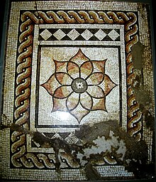
In the center of the city, excavations discovered the remains of the forum, a temple area and a large stone theater. The theater was built around 80 to 90 AD and was expanded again at the beginning of the third century. The remains of at least two thermal baths have also been found. A large building was found to the west of the city, which may have been a mansio , a rest house. Remnants of residential buildings, initially made of wood and later mostly of stone, have been found throughout the city. So far there are 14 remains or better preserved mosaics . They mostly show geometric patterns. However, a city wall was not erected until the end of the third century. There were various necropolises outside the city wall .
There is ample evidence of handicrafts in the city. Workshops were mainly found in the northwest of the city, outside the city walls. During excavations, pottery and brick kilns were found. There was iron and bronze processing. There were also limestone quarries outside the city walls.
The city was abandoned after Roman rule in the fifth century. There are some rich hoards (e.g. the late Roman treasure of Canterbury ) that date to around 450 AD and may indicate an abrupt end of the city during the armed conflict with the Anglo-Saxons . It is likely that wealthy citizens wanted to secure their treasures from looting during a siege of the city, but were later unable to regain their possession.
Remarks
- ^ David S. Neal, Stephen R. Cosh: Roman Mosaics of Britain, Volume III: South-East Britain, Part 2 , London 2009, ISBN 978-085431-289-4 , pp. 359-369
literature
- John Wacher: The Towns of Roman Britain. Routledge, London / New York 1997, pp. 189-207 ISBN 0-415-17041-9
Web links
- Emil Huebner : Durovernum . In: Paulys Realencyclopadie der classischen Antiquity Science (RE). Volume V, 2, Stuttgart 1905, Sp. 1865.
- Durovernum Cantiacorum (Eng.)
- Roman city plan
- Roman Canterbury, picture gallery
Coordinates: 51 ° 16 ′ 44.4 " N , 1 ° 4 ′ 55.2" E


