
Portus Dubris
| Dover forts a) Fleet fort (FK), b) Saxon coastal fort (SKK) |
|
|---|---|
| Alternative name |
a) Portus Novum , b) Portus Dubris , c) Dubris , d) Douvrae |
| limes | Britain |
| section | Litus saxonicum |
| Dating (occupancy) |
a) 1st to late 3rd century AD, b) 3rd to 5th century AD. |
| Type |
a) Fleet station b) Limitanei fort |
| unit |
a) Classis Britannica , b) Milites Tungrecanorum |
| size |
a) approx. 2 ha, b) 5 ha |
| Construction |
a) stone construction, b) stone construction |
| State of preservation |
a) square system with rounded corners, b) trapezoidal system with protruding towers, partly still visible above ground (north gate of the FK, intermediate tower of the SKK) |
| place | Dover |
| Geographical location | 51 ° 7 '43 " N , 1 ° 19' 23" E |
| Previous | Rutupiae fort north |
| Subsequently | Lemanis fort south |


.jpg)

_p087_Fig.1_Roman_pharos_in_Dover_Castle.jpg)


Portus Dubris (Dubris) is the collective term for a Roman port, settlement and two forts in the urban area of Dover , Kent , England .
Portus Dubris occupied a key position in trade and was the headquarters of the Classis Britannica on the British side of the English Channel. It was one of the two main gates to Roman Britain, or one of the most frequented port of call for ship traffic and connected the island with Portus Itius and Gesoriacum (today Boulogne-sur-Mer ) on the Gallic coast. The Roman fleet controlled the waters of the English Channel and the North Sea from here.
From the 3rd century on, Dubris was part of the chain of castles of the so-called Litus Saxonicum ( Saxon coast ), a military district of the late antique Limes Britannicus . The port had a lighthouse on the western and eastern side of the port entrance. The eastern one is still well preserved and is now located within the medieval castle complex. It used to be the bell tower of St. Mary's Church in Castro. This church was built with building materials from the ruins of the late Roman camp.
While many of the canal ports of ancient Britain became unusable due to siltation, Dover has been able to maintain its position as an important commercial and travel port to this day.
Surname
The ancient name means: "the port on the Dubras river". Dubras is a term derived from the Celtic (= water).
- Claudius Ptolemy mentioned it as Portus Novus .
- In the Antonini Itinerary , the port appears as the starting point of the third route (Iter III) in Britain.
- In the Notitia Dignitatum of the 5th century, in the
- Tabula Peutingeriana and in the 7th century at
- Ravenna geographers mention the place as Dubris .
In Anglo-Saxon times the place was known as Douvrae . In Anglo-Saxon texts it is also referred to as Dofras, Dobrum, Doferum, and Doferan .
location
Dubris stood on the coast of the English Channel, on the west bank of the mouth of the River Dour, and was 34 km from Cap Gris Nez, Calais , and 40 km from Bolougne-sur-Mer , both in what is now France . The route Dubris-Gesoriacum was due to their geographical location, the shortest route between mainland Europe and British Isles. Dubris was also one of the few places in this region that allowed ships to land without problems between the steep cliffs averaging 100 m high. In addition to Rutupiae , Dubris was one of the starting points of Watling Street (Anglo-Saxon: Wæcelinga Stræt), a Roman road to Durovernum Cantiacorum and Londinium . It was one of the first great military roads that the Romans laid in Britain. From Londinium it led via St. Albans (Verulamium) , Dunstable (Durocobrivis) , Towcester (Lactodurum) to Wroxeter (Viroconium) in the north, then branched off to Wales and the metropolis of the north, York (Eburacum) .
Research history
In the 19th and 20th centuries, a massive harbor wall and smaller piers were discovered. These findings confirmed the existence of a major Roman port. The late antique fort was first examined and described by Mortimer Wheeler in 1929 . However, a number of re-excavations to confirm this identification failed. A detailed analysis of the findings available up to that point could not be published until 1970. The extensive rescue excavations by the Kent Archaeological Rescue Unit (KARU), as a result of the construction of a bypass road and the redevelopment of the town center, began in 1970. An area of around eight hectares in the city center was examined. The excavation area was partially covered by alluvial sand and erosion deposits over seven meters high from the neighboring western heights. The year 1970 also marked the beginning of a series of rescue excavations by the KARU, which lasted more than 30 years, which led to the discovery of a further abundance of building structures from Roman and Anglo-Saxon times. Until 2010, 200 m of the south and west wall, seven of its towers, the weir ditch, the inner earth wall and some sections of the inner area were explored from the Saxon Coast Fort.
The oldest finds from the Dover region date from the Bronze Age. In 1974 there were bronze axes, which probably come from Gaul, in 1992 the remains of an approximately 17 m long antique boat were found. Both finds can be seen in the Dover Museum. The range of finds includes u. a. two Roman altars, a statue, two stone heads and a large number of Roman gems. A gladiator scene was depicted on one of them .
development
The traces of settlement in Dover go back almost 4000 years. Gaius Iulius Caesar tried in 55 BC To land with his fleet on the beach of Dubris , however, failed because the British tribes had concentrated their forces on the surrounding rocky cliffs. In 43 AD the region around the mouth of the Dubras was occupied by the invading army of Aulus Plautius . In the early 2nd century, the Roman canal fleet founded a first fort here. Dubris was soon one of the most important Roman ports on the British coast , along with Rutupiae . To the west of Lemanis Fort were the ore mines of the South Downs ; they were probably administered from Dubris .
In the late 3rd century, the Roman military built a new fort over the former naval camp as part of the expansion of the Wash-Solent-Limes to protect against attacks by the Angles and Saxons . When the Saxon Coast Fort was built in Dubris , no consideration was given to the older structures, which suggests that there was no continuity of settlement on the area between the port and the late antique fortress. The ships of the Classis Britannica were mainly stationed in the southern and eastern ports of the island. Their patrols monitored the Oceanus Britannicus in order to be able to react quickly against potential pirates, to intercept them and to destroy their ships as soon as they appeared in the English Channel. During this time, for various reasons, there were increased efforts by the barbarian peoples to get to the island, to plunder there or to settle permanently. If you could not prevent their landing, the fleet tried to cut off the looters' retreat across the sea.
After the Romans withdrew in 410 and the Romano-British were defeated at Aylesford 455 and 457 at Crecganford, Dover fell into the hands of the Saxons under Hengest, along with Canterbury and Richborough . He founded the first Saxon kingdom on British soil. Seven Anglo-Saxon kingdoms emerged over the next 200 years. Dubris became Dorfa , later Dofris . In the 6th century a Saxon settlement (Douvrae) established itself within the fort. In the 7th century, Widred, King of Kent (690–725), built a monastery and chapel there. It was dedicated to Saint Martin of Tours and stood on the west side of today's market square. After the Battle of Hastings in 1066, the Normans burned Douvrae and its monastery. Duke Wilhelm then ordered the monastery and its church to be rebuilt. It is said that St. Martin-le-Grand was the most magnificent church in England at the time. In the Domesday Book of 1086, the city's name appears as Dovere .
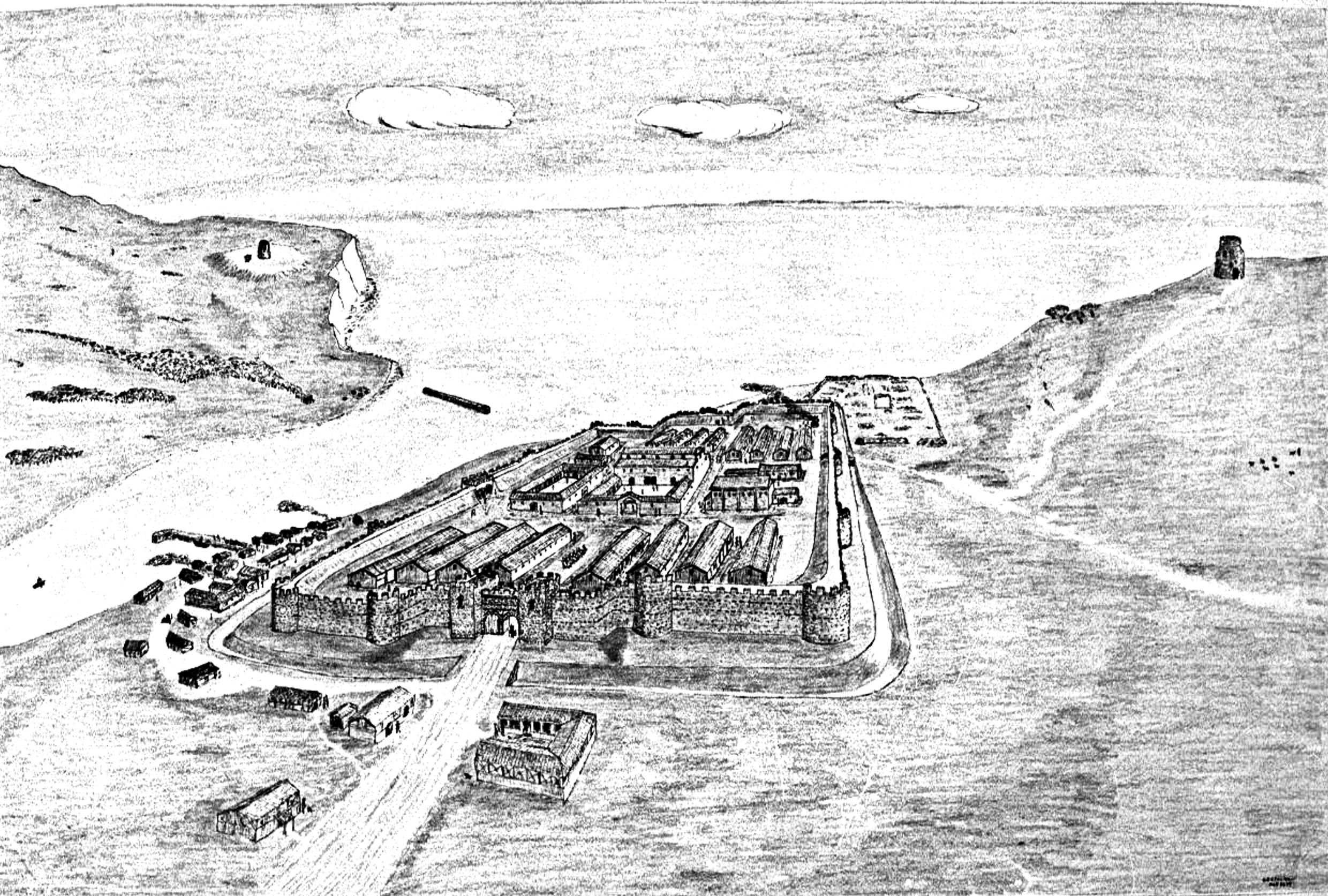
Fleet fort
The multi-phase medieval fort stood near the coast on the slopes of the Western Heights and is now largely below the city center of Dover (around York Street (A 268) and Queen Street). It covered an area of around 2 hectares and was probably one of the most important bases of the Classis Britannica in Britain. It was the only Roman naval base in Britain that has been systematically investigated to date. Two limited excavation campaigns gave an approximate impression of the appearance and extent of the fortress. It was certainly - like most of the Roman castles of that time - square with rounded corners, since an angle of 90 degrees could be observed on the south and west wall.
The first phase of construction (probably between 110 and 117) remained unfinished. From here, the KARU was able to uncover the remains of the fort wall and three barracks blocks in 1970. A second fort (at the same location, size 1.5 ha) replaced it between 125 and 130 and was initially occupied until 155. During this time, the surrounding wall, a moat, two gates, up to 14 inner buildings, warehouse roads and a sewer system were built. The fort seems to have been abandoned afterwards. From 190 to 208 it was once again occupied by Roman troops, but then finally left to decay. By 270 many of its buildings had collapsed and covered with a layer of earth. The camp wall was broken through by four gates, the north and south gates were shifted slightly to the east. The location of the north gate (at the Discovery Center) is known from the fence. It had two passages and was flanked by two rectangular towers attached to the inside. The east gate was secured by two horseshoe-shaped towers, the fronts of which protruded over the camp wall. Corner towers do not seem to have been present. The inner buildings comprised the Principia with administrative offices (Officia) , ten barracks with eight counter-bernias each, two granaries (horreum) and a latrine . Some of the walls were up to three meters high when they were exposed. These were the best preserved Roman military buildings in southern Britain. Around 800 Classis Britannica brick stamps were also recovered during the excavations .
Saxon Coast Fort
This five-hectare multi-phase camp, built after 270, was located on the west bank of the Dour estuary. It was partially on the area of the fleet fort (NE corner). The trapezoidal complex, slightly offset to the northwest, consisted of a massive stone wall with semicircular bastions protruding far from the wall. The floor plan is very reminiscent of that of Burgh Castle . So far only the southwest corner and parts of the south and west walls have been excavated. Four towers could be examined more closely. When it was abandoned by the Roman army is unclear. It is very likely that it was occupied by Anglo-Saxons from the 6th century, who founded a settlement in it.
Fence and trench
During the excavation, individual sections of the wall were still in a relatively good state of preservation. It was also possible to distinguish between several expansion phases. They were built mainly from limestone and tuff , most of which probably came from the demolition material of the naval fort. A seven-meter-long section of the west wall cut through rooms 3 and 4 of the 2nd century mansio (Painted House). When building the fort wall, primarily locally available stone material was used. Their width is between 2.3 and 2.6 meters. It was additionally supported and reinforced by an inner earth ramp (intervalum) , which also served as a battlement. The outer cladding was made up of hewn tufa blocks, the inner filling mostly of roughly cut chalk lime blocks. Its foundation consisted of a mortared rubble-brick conglomerate. The latter came from demolished previous buildings in the vicinity. The core of the wall also contained a lot of recycled material. Apart from a slight gradation in the foundation on the outside, no other special features were found.
About five meters in front of the wall (south and west side) ran a 7.5 m wide, V-shaped weir ditch as an approach obstacle, which was spanned by a bridge at the main gate.
Towers
So far, a total of seven semicircular towers or bastions could be located at intervals of 23 to 30 meters. Two building types were identified. Some were integrated into the wall, others were obviously added later; possibly because otherwise the gaps between them would have been much too great. One of them stood on the remains of the mansio (rooms 5 and 6), the masonry was still four to six meters high when it was exposed. Considerable differences were also found in the composition of the building material. The towers built first are made of limestone and tuff. The specimens that were added later were made of flint quarry stone and had brick tapes on the outside .
Interior development
The remains of 11 wooden buildings with circular, square and oval ground plans, as well as pit houses, ovens and pits were discovered in the fort. The thermal baths of the Vicus from the 2nd century were integrated into the Saxon coastal fort, rebuilt and reused. It was probably built by naval soldiers. Well-preserved remains of a large furnace and a number of rooms with hypocaust heating and water basins were found. The rooms were all grouped around a large courtyard. The south-west corner of the fort was heaped up, then leveled and built on with smaller, oval huts and wooden frame structures.
The interior development of the Anglo-Saxon period consisted mainly of pit houses in wood construction with clay floors in various sizes. In total, traces of around 18 wooden buildings or their charred wall planks were found in situ. They provided new knowledge about the construction in the 7th century. There were also signs of a larger stone-floored hall and a paved road that was in use from the 7th to the 10th centuries.
weaving
During the excavation in room 1 of the mansio , the remains of an approximately 7 m × 4 m large, wooden pit house from the Anglo-Saxon period (approx. 800 AD) that had been destroyed by fire were discovered. It was a simple hut made of boards and posts, typical of Anglo-Saxon houses from the 5th to 8th centuries. A weaver's workshop was probably housed in the building. During the excavation almost 200 round clay and loom weights were recovered.
garrison
The crew of the naval fort in Dubris consisted of members of the Classis Britannica , who were supposed to monitor the waters around Britain and above all the English Channel with their ships. According to the Notitia Dignitatum, a Praepositus militum Tungrecanorum Dubris , "Commander of the soldiers of the Tungrecani in Dubris", under the command of the Comes litoris Saxonici per Britanniam , was stationed in the late antique fort at the end of the 4th century .
port
The harbor, which is well protected due to the natural conditions, was founded around the year 50. Initially it was relatively small. It consisted mainly of a wooden quay, the warehouse in which the fleet soldiers of the Classis Britannica were housed, and a mansio . The mouth of the Dour was 3.4 km wide at that time, the tidal range was up to three meters. It was later blocked by a massive wall running from east to west. The warships as well as various auxiliary and cargo ships moored at piers that lined up on the west bank of the river mouth.
Lighthouses
Soon after landing in Britain (43 AD), the Romans built a lighthouse (Pharos) in Dubris . This tower and the later second tower stood on the two hills (Eastern Heights and Western Heights) flanking the harbor basin above the - at that time still much wider - river mouth. The lighthouses made navigation much easier, as their firelight was clearly visible from both sides of the canal - in cloudless weather. At night it was reinforced with a polished copper reflector. During the day, the column of smoke guided the ships. The towers were probably operated by soldiers from the naval fort. The bricks of the Classis Britannica (stamped Cl BR) used in the construction were of the same quality as those of the Mansio and the Naval Fort. The buildings should all have been built at the same time. Later the eastern tower was converted into a watchtower. The Church of Saint Marys in Castro was built in the late 10th or early 11th century. Its walls contain a large amount of recycled Roman bricks. From about 1252 the east tower served as the bell tower of the castle church. It is believed that it was extensively repaired in 1259 and also covered with a layer of flint. Presumably commissioned by Richard de Codnore, Constable of Dover Castle. His coat of arms is embedded on the north side of the Pharos. As part of another comprehensive renovation program, it was renovated again from 1580 to 1582, including a. provided with a new base and roof so that it can also be used as a powder magazine. In 1724, William Stukeley reported that the Ordnance Office had the roof removed. However, it is unclear whether Stukeley meant that of the eastern Pharos , but it is very likely.
East tower
The eastern lighthouse now stands within Dover Castle and is the tallest of the Roman buildings still standing in Britain. It was very similar to the one that Emperor Caligula had built on the occasion of his - failed - invasion of Britain. He is said to have stood in Lugdunum Batavorum . Boulogne-sur-Mer , mentioned earlier in this context , is presumably excluded from these considerations, as there is no evidence of a Roman presence there in the time of Caligula. The outer floor plan is octagonal. Its original eight storeys tapered upwards in steps, giving the structure a telescopic appearance. Today only the first four are preserved, but badly weathered, a result of its exposed location on the hill. In contrast, the interiors are square. It is twelve meters wide and still reaches a height of 13 m. Its original height should have been around 25 m. The walls are up to four meters thick. They are made of flint, brick and tuff. The windows and entrance gate are arched, and tufa and bricks are alternately walled up in the arches to create a polychrome effect. The 5.8 m high tower crown dates from the 15th century.
West tower
A remnant of the wall of the western lighthouse that was rediscovered in the 1860s is known as “Bredenstone”, “Caesar's Altar” or “Devil's Drop” and is now located within the walls of the so-called Drop Redoubt (Western Heights), a coastal defense fort from the 18th century . Judging by the reused Classis Britannica roof tiles , however, the tower was probably not built until the 4th century.
Vicus
The somewhat sloping area of the Roman vicus of Dover probably covered at least an area of ten hectares. It was located on the west bank of the Dour estuary and on the north side of the naval fort. The civil settlement probably originated in the late 1st century. Most of the houses were built of wood and stone and decorated with mosaic floors and painted stucco. Although some larger stone buildings, basilica, forum, temple and also a bath could be proven, it never seems to have reached urban proportions.
Mansio / Painted House
To the north of the naval fort was a two-story building that was built between 150 and 160 AD and was later rebuilt several times. The parts of the last expansion phase - around 200 - were particularly well preserved, as they were covered by the western wall and the inner earth wall of the Saxon coast fort in late antiquity. The "Painted House" originally had 80 or more rooms and is one of the most famous Roman buildings in Great Britain. The motifs of his wall paintings and the proximity of the building to the fort baths, the harbor and the naval base initially led to the assumption that it was just an ordinary brothel. However, this thesis was rejected again, as frescoes in Roman brothels tended to depict all variations of the services offered there, as was evident in Pompeii . Bacchus motifs were, however, very often found in residential buildings. Most scientists also believe that the space was far too small for a brothel.
It was discovered during the construction of the A256 bypass in the 1970s. The Kent Archaeological Rescue Unit, headed by Brian Philp, succeeded in uncovering and conserving five rooms (each approx. 18 × 16 m) and a corridor in front of it. It was a Roman mansio , partially equipped with wall and floor heating (hypocausts) . Three of the rooms were heated by means of an external arc furnace. During the excavations, walls were found - in some places still six meters high - with well-preserved wall paintings , the largest ever found north of the Alps. On multi-colored, framed panels with a 3D effect, they showed architectural motifs such as B. fluted columns. On 28 plates there are mainly depictions of Bacchus , the Roman god for joie de vivre and enjoyment of wine, and Ariadne (about five pieces per wall).
Inscriptions
Three Roman inscriptions are known from Dover. One was dedicated to the matrons by a Roman official from the provincial capital . Another text (EVSEB III IV IV [ius?] ... VSI ... ... ST ...) was badly damaged.
Hints
A small part of the late antique fortress has been preserved and can be viewed on request in the Dover Library and the Discovery Center (former White Cliffs Experience). The most extensive - publicly accessible - Roman remains are those of the Painted House, where the walls of the Mansio, the Saxon Coast Fort and the Naval Fort can be viewed.
literature
- Brian Philp: The Excavations of the Roman Forts of the Classis Britannica , Dover 1970–1977, 1981.
- Brian Philp: The Roman House with Bacchic Murals at Dover , Kent 1989.
- Brian Philp: The discovery and excavation of the Roman shore-fort at Dover, Kent (= Kent monograph series. 11). Kent Archaeological Rescue Unit, Dover 2012.
- Brian Philp / John Willson: The discovery and excavation of Anglo-Saxon Dover, Detailed report on fourteen of the major Anglo-Saxon structures and deposits discovered in the center of ancient Dover, during large scale rescue-excavation 1970–1990 (= Kent monograph series. 9). Kent Archaeological Rescue Unit, 2003.
- Nic Fields: Rome's Saxon Shore Coastal Defenses of Roman Britain AD 250–500 (= Fortress. 56) Osprey Books, 2006.
- Anthony David Mills: Oxford Dictionary of English Place-Names. Oxford University Press 1998.
- Robin George Collingwood / Richard Pearson Wright: The Roman Inscriptions of Britain. Oxford 1965.
- David E. Johnston: The Saxon Shore . The Council for British Archeology, London 1977 ( Research Report No. 18). pdf
- Mortimer Wheeler: The Roman lighthouses at Dover. In: Archaeological Journal. Volume 86, 1929, pp. 29-58 (printed separately 1930).
- Stephen Scoffham: The Romans in East Kent; a brief guide. North Kent Books, Rochester 1982, ISBN 0-9505733-7-X .
- Thomas Fischer: The army of the Caesars. Archeology and history. With contributions by Ronald Bockius , Dietrich Boschung and Thomas Schmidts . Pustet, Regensburg 2012, ISBN 978-3-7917-2413-3 ; 2nd, revised and updated edition 2014, ISBN 978-3-7917-2413-3 .
- George Clinch: English coast defenses from roman times to the early years of the nineteenth century. G. Bell & Sons Ltd., London 1915.
Web links
- Description of the location with illustrations
- Dover Roman Painted House
- Dover Historian. A collection of historical articles from the town of Dover, England, by Lorraine Sencicle
- Murals in Dover Painted House
- Council for Kentish Archeology
- Interior view of the eastern lighthouse
- View of the lighthouse from 1722
- 18th century illustration of Bredenstone
- Reconstruction of the Saxon Coast Fort
- KAR Articles: The Discovery of the 'Classis Britannica "and" Saxon Shore "Forts at Dover. Interim Report on the 1970 Excavation.
Remarks
- ↑ "The Route from Londinium to Portus Dubris - 66,000 Steps" and Portum Dubris, 13 miles away from Durovernum Cantiacorum (Canterbury, Kent).
- ↑ Fischer 2014, pp. 364–365
- ↑ Notitia Dignitatum occ. XXVIII, 14.
- ↑ George Clinch 1915, p. 52.
- ↑ AE 1977, 497 : St (rator) co (n) s (ularis) / Ol (us) Cor [dius] / Candid (us) [Mat] / rib (us) Italic [is] aedem [fe] cit v (otum) s (olvens) [l (ibens) m (erito)] "the messenger of the governor's office (in London), Olus Cordius Candidus, built this temple for the Italian mother goddesses to willingly and deservedly fulfill his vows".
