Fort Square (Moers)
| Fort place | |
|---|---|
| Place in Moers | |
 Old town with town church (1899) |
|
| Basic data | |
| place | Moers |
| District | Old town |
| Created | 1763 and 1966–1974 |
| Confluent streets | Kleine Allee, Klosterstrasse, Haagstrasse |
| Buildings | Old partnership, old district office, White House , Terheydenhaus, Moerser Schloss , St. Josefskirche , Tersteegenhaus, historical a. a. Zum Impel, Scheidtmann's house |
| use | |
| User groups | Foot traffic ; Car / bicycle traffic on the west and east sides |
| Space design | Pedestrian area, side lanes, parking lot |
The fort square , also known as "fort" for short, is located near Moers Castle , partly in the inner area of the former fortress star that once surrounded the castle. Next to Neumarkt , which is almost directly to the north, it is one of the large squares in downtown Moers and has a long trapezoidal floor plan.
The square is surrounded by the Old Society, the Old District Office, the White House , the Terheyden House, the Moers Castle , in front of which the monument to Luise Henriette by the sculptor Heinrich Baucke , the castle park , the St. Joseph Church , the Tersteegen House, historical and similar. a. To Impel and the Scheidtmann house.
The area of today's fort square was formerly part of an arm of the Rhine, on the banks of which a settlement was built over 900 years ago and a residential tower on an artificially created hill , from which today's city of Moers and the castle emerged.
history


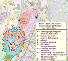
In the Middle Ages, wide trenches of the dammed Moersbach, which separated the old town, the new town and the castle with its walls, lay at the site of the fort square .
In addition to the moats , walls and towers protected the old town , the new town and the castle with its outer bailey and bastions.
Bridges connected the two parts of the city and the castle.
With the construction of the new fortification by Moritz von Oranien (1567–1625) from 1601 to 1620, the castle and the city were combined in a star-shaped wall and moat.
The fortifications were razed in 1763/64 , the moat between the old town and the castle was filled and rebuilt. The Protestant and Catholic elementary schools were located there, which were demolished in the course of the expansion of the space and the unrealized construction project for the construction of a town hall in 1974, as had previously been the case with a block of houses along Haagstrasse called an " iron " in 1966 .
Events
Various events take place on and around the fort square.
The Moerser Kirmes , which takes place every year on the 1st weekend in September and extends from Friedrich-Ebert-Platz over Homberger Straße and Steinstraße to Neumarkt , also uses the fort square.
The Christmas market also takes place on the fort square during Advent .
literature
- Wolf Strache : Moers. (= The beautiful books. Volume 29 and German cities. Volume 32). DSB Verlag, Stuttgart 1965, DNB 453426514 .
- Birgit and Rainer Schiffler: The architectural and art monuments. In: The Wesel district. Konrad Theiss Verlag, Stuttgart 1983, ISBN 3-8062-0288-5 .
- Gabriele M. Knoll: The Lower Rhine; Landscape, history and culture on the lower Rhine. Du Mont Buchverlag, Cologne 1990, ISBN 3-7701-2283-6 .
- Margreth Wensky, Andrea Rönz (ed.): Moers the history of the city from the early days to the present. Volume 2: From Prussian times to the present. Böhlau Verlag, Cologne / Weimar / Vienna 2000, ISBN 3-412-04600-0 .
- Kristin Dohmen, Giesbert Knopp (Red.): Moers. Castle - cultural center. Festschrift for the 100th anniversary of the Grafschafter Museum and History Association Moers eV; Werner publishing company. Worms 2004, ISBN 3-88462-205-6 .
Web links
Individual evidence
- ^ Gesellschaft Sozietät zu Moers ( Memento of the original from January 23, 2016 in the Internet Archive ) Info: The archive link was inserted automatically and has not yet been checked. Please check the original and archive link according to the instructions and then remove this notice.
- ↑ History station 08: Moers as a district town
- ↑ Monument plaque 07: Wittfeldsche Heilanstalt
- ↑ gmgv-moers.de Museum Association for the Preservation of the Terheydenhaus September 2014 ( Memento of the original from August 11, 2016 in the Internet Archive ) Info: The archive link was inserted automatically and has not yet been checked. Please check the original and archive link according to the instructions and then remove this notice.
- ↑ Entry of the Gerhard-Tersteegen-Haus, Haagstraße 11 as a monument in the list of monuments of the city of Moers
- ↑ History station 10 teachers' seminar
- ↑ rp-online.de October 1, 2015 The iron house then and now
- ↑ gmgv-moers.de The urban development of the city of Moers in the 20th century -3.part- by Thorsten Kamp
- ↑ Moerser Kirmes
- ↑ Moers Christmas Market, accessed on August 10, 2016
Coordinates: 51 ° 27 ′ 0.9 ″ N , 6 ° 37 ′ 31.7 ″ E


