
Kazimierski Park Krajobrazowy
|
Kazimierski Park Krajobrazowy
|
||
 The Vistula in the area of the Landscape Protection Park |
||
| location | Lublin , Poland | |
| surface | 149.74 | |
| Geographical location | 51 ° 20 ' N , 21 ° 59' E | |
|
||
| Sea level | 200 m | |
| Setup date | April 27, 1979 | |
| particularities | Former World Heritage candidate , Lösshohlwege | |

The Kazimierz Landscape Protection Park (Kazimierski Park Krajobrazowy) is a nature reserve of the Landscape Protection Park category in the Lublin Voivodeship , Poland .
It takes its name from the small town of Kazimierz Dolny , which became famous for its Renaissance buildings and attracts 1.5 million tourists annually. The park is located on the territory of various municipalities in powiat Puławski and powiat Opolski . The park administration is located in the city of Lubartów .
The landscape protection park was founded on April 27, 1979; since an expansion it has an area of 149.74 km² and a buffer zone of 246.44 km². The Kazimierz Dolny- Janowiec - Nałęczów region was on the tentative list of World Heritage in Poland from 1993–1996 .
There are two nature reserves in the park. A reserve includes the 62.3 hectare Krowia Wyspa (Cow Island) in the Vistula. It protects a breeding ground for oystercatchers , sand and little ringed plover , lapwing , steppe , Schwarzkopf and gulls , river and little terns .
A second nature reserve is the 39.7 hectare Skarpa Dobrsk. In this valley in the south of Kazimierz Dolny, you can observe geological formations as well as rare plants and animals. For example, it is a place of retreat for the bio-indicator and cultivator Fetthennen-Bläuling , which is on the red list of endangered species in Germany .
The wildlife of the park also includes the European pond turtle , which can be found in the Plewka Valley. The area around Kazimierz Dolny is rich in loess pathways .
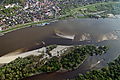
Island in the Vistula
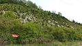
Skarpa Dobrsk

“Valley of the roots” hollow path in the loess


Web links
Individual evidence
- ^ Kazimierski Park Krajobrazowy. (Polish, on an archived website)