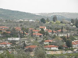
Kedumim
|
Kedumim קדומים |
||

|
||
| Territory : |
West Bank ( Judea and Samaria ) |
|
| Municipal administration : | Kedumim | |
| Coordinates : | 32 ° 13 ' N , 35 ° 9' E | |
| Height : | 405 m | |
| Area : | 2,313 km² | |
| Residents : | 4,323 (2016) | |
| Population density : | 2 inhabitants per km² | |
| Mayor : | Chanan'el Dorani | |
| Website : | ||
|
|
||
Kedumim is an Israeli settlement in the West Bank , west of Nablus . The place is spread over several hills and stretches for about three kilometers in a southwest-northeast direction.
history
Kedumim was founded in 1975. Since 1991 the place has been an independent municipal administration (מועצה מקומית קדומים).
In 1996 the first elections for the office of mayor took place. Daniella Weiss became the first female mayor of Kedumim.
4,323 settlers live there (as of 2016). There are several yeshivot in Kedumim , including the Yeshivat Bnei Chayil, Shomron (ישיבת בני חיל, שומרון).
Residents
The Israeli Central Bureau of Statistics gives the following population figures for Kedumim in the censuses of June 4, 1983, November 4, 1995 and December 28, 2008:
| Year of the census | 1983 | 1995 | 2008 |
| Number of inhabitants | 910 | 2.200 | 3,463 |
mayor
- 1996 - 2009 Daniella Weiss
- 2009 to date Chananel Dorani
Web links
Commons : Kedumim - collection of images, videos and audio files
Individual evidence
- ↑ myesha.org.il
- ↑ cbs.gov.il ( Memento of the original from May 17, 2018 in the Internet Archive ; PDF) Info: The archive link was inserted automatically and has not yet been checked. Please check the original and archive link according to the instructions and then remove this notice. Israel Central Bureau of Statistics. Retrieved April 21, 2018
- ↑ Yeshivat Bnei Chayil, Shomron (ישיבת בני חיל, שומרון)
- ^ Israel Central Bureau of Statistics
