Kennetcook River
| Kennetcook River | ||
| Data | ||
| location | Hants County in Nova Scotia (Canada) | |
| River system | Avon River | |
| Drain over | Avon River → Bay of Fundy | |
| source | east of Doddridge 45 ° 13 ′ 12 ″ N , 63 ° 35 ′ 39 ″ W. |
|
| Source height | approx. 50 m | |
| muzzle |
Estuary of the Avon River coordinates: 45 ° 2 '55 " N , 64 ° 7' 35" W 45 ° 2 '55 " N , 64 ° 7' 35" W
|
|
| length | approx. 55 km | |
| Catchment area | 506 km² | |
| Communities | Kennetcook , Clarksville | |
|
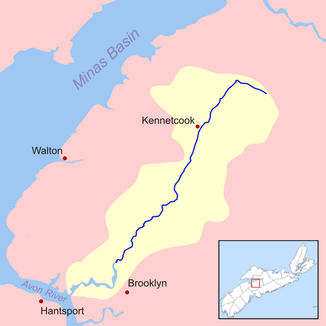
Kennetcook River catchment area |
||
The Kennetcook River is a right tributary of the Avon River in the Canadian province of Nova Scotia .
The Kennetcook River rises east of Doddridge in Hants County . It flows in a predominantly south-southwest direction past Kennetcook and Clarksville . After about 55 km it reaches the estuary of the Avon River north of Windsor, which flows into the Minas Basin . The Kennetcook River has a catchment area of 506 km². Twice a day, a tidal wave rolls upstream from the Bay of Fundy up the lower reaches of the Kennetcook River. It is still noticeable in Scotch Village .
The Nova Scotia Highway 236 follows the course of the river not far from the southern bank of the river.
The Kennetcook River is a spawning area for Atlantic salmon . The construction of a road dam on the Avon River directly above the confluence of the St. Croix River resulted in extensive mud fields in the downstream direction, which have an impact on the hydrology and fauna of the Kennetcook River.

