Kern River
| Kern River | ||
| Data | ||
| Water code | US : 255515 | |
| location | California (USA) | |
| source |
Sierra Nevada 36 ° 41 ′ 48 " N , 118 ° 23 ′ 53" W. |
|
| muzzle |
Buena Vista Lake Coordinates: 35 ° 16 ′ 4 " N , 119 ° 18 ′ 25" W 35 ° 16 ′ 4 " N , 119 ° 18 ′ 25" W |
|
| Mouth height |
91 m
|
|
| length | 264 km | |
| Reservoirs flowed through | Lake Isabella | |
| Medium-sized cities | Bakersfield | |
| Small towns | Kernville | |
|
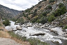
Upper reaches of the Kern River |
||
The Kern River is an approximately 264 kilometer long river in the US state of California . It drains part of the southern Sierra Nevada northeast of Bakersfield . Fed by the meltwater in the vicinity of Mount Whitney , the river passes scenic canyons in the mountains and is a popular destination for rafting and kayaking . It is the only major river in the Sierra Nevada mountains that drains them south.
The Kern River used to flow in full into Buena Vista Lake at the southern end of California's Central Valley, which is now dry . Currently, however, the river is almost completely diverted for irrigation purposes and is used for groundwater feed as well as for the California Aqueduct . So only a small part of the original amount of water ends up in Lake Webb and Lake Evans , two small lakes in a part of the former Buena Vista Lake, which were created in 1973 for recreational purposes.
River course
The Kern River is the southernmost river in the San Joaquin Valley . It rises in the Sierra Nevada in the east of Tulare County and ends in the west of Kern County , where it is derived for the most part for irrigation purposes. Its two headwaters, North Fork Kern River and South Fork Kern River , unite in Lake Isabella , a reservoir created in 1953 .
The main branch of the river (also called North Fork Kern River ) is fed by several small lakes west of Mount Whitney in the northeast corner of Sequoia National Park . From there it flows south through the mountains, passes the Inyo National Forest and Sequoia National Forest , as well as the Golden Trout Wilderness . At a point called the Forks of the Kern , it takes up the Little Kern River coming from the northwest . At Kernville the river leaves its narrow canyon and flows into Lake Isabella in a wide valley. The area was once known as Whiskey Flat , the former location of the city of Kernville.
Just like the North Fork , the South Fork Kern River has its source in Tulare County and flows mainly south through the Inyo National Forest. After reaching Kern County, the South Fork changes its direction to the west until it finally flows into Lake Isabelle.
After exiting the reservoir through Isabella Dam , the Kern River flows southwest through spectacular canyons along the southern rim of the Greenhorn Mountains until it exits the mountains east of Bakersfield . In the lower reaches of the river after passing Bakersfield, its water is drawn to a large extent through a series of canals for irrigation of the southern San Joaquin Valley , as well as for drinking water for the greater Bakersfield area. In the Bakersfield area, the Kern River used to expand into large marshland with temporary lakes.
The Friant-Kern Canal , built as part of the Central Valley Project (CVP), flows into the river approximately 6 km west of Bakersfield city center.
The Kern River is one of the few rivers in the Central Valley that does not contribute water to the Central Valley Project. However, the water from the CVP, mainly from the Friant Kern Canal, is used to recharge the groundwater.


