Khurdoping glacier
| Khurdoping glacier | ||
|---|---|---|
|
Khurdopingletscher and the NE wall of the SE ridge of Kanjut Sar |
||
| location | Gilgit in Gilgit-Baltistan ( Pakistan ) | |
| Mountains | Hispar Muztagh ( Karakoram ) | |
| Type | Valley glacier | |
| length | 36 km | |
| Exposure | North | |
| Altitude range | 7700 m - 3600 m | |
| width | ⌀ 1.6 km | |
| Coordinates | 36 ° 13 ′ N , 75 ° 30 ′ E | |
|
|
||
| drainage | Shimshal → Hunza → Gilgit → Indus | |
|
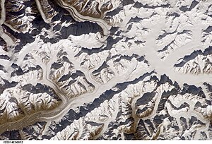
Satellite image from Hispar Muztagh; Khurdopingletscher in the middle at the top of the picture. |
||
The Khurdoping Glacier is located in the western Karakoram in the Pakistani special territory of Gilgit-Baltistan .
The Khurdopingletscher has a length of 36 km. It flows in a northerly direction through the northern part of the Hispar Muztagh mountain range . The Khurdopingletscher has the two source glaciers Western and Eastern Khurdopingletscher . Its drain flows into the Shimshal . The Khurdopingletscher is framed by the following mountains (from west to east): Kanjut Sar I ( 7760 m ), Kanjut Sar II ( 6831 m ), Tahu Rutum ( 6652 m ) and Lukpe Lawo Brakk ( 6593 m ). A mountain ridge separates the Khurdopingletscher from the Yukshin-Gardan-Glacier, which runs parallel to the west .
Web links
- Map at himalaya-info.org


