
Klüt (Hamelin)

The Klüt is about 258 m above sea level. NN high mountain, which lies west of the core city of Hameln in Lower Saxony . It rises above the Weser valley and is Hameln's local mountain . The top of the Klüt and the lower area of the Finkenborn serve as excursion destinations for local recreation .
description
The wooded Klüt belongs to the Hameln municipal forest as a landscape protection area and is used for forestry purposes. On the top there is a plateau with various recreational facilities. This includes the Klütturm as a lookout tower . Below the tower there are two viewpoints from which the view of the old town of Hameln with the Weser and the middle Weserbergland falls. Next to the Klütturm are the remains of the fortifications built in the 18th century on the Klüt , which stretched from there as four independent forts on the sloping, narrow ridge to the Weser. On the hilltop is the new building of a gastronomic business with a hotel, built in 2009 on the site of the Klüthaus as the previous building.
Below the Klütkuppe lies the Finkenborn, which is a plateau with a large forest clearing. The name given to the -born designation is a pond lying there. At Finkenborn there is a youth hostel, a sports area, a kindergarten and a restaurant in the former forester's house. There is also a game reserve , a children's playground and a high ropes course in the area . The Finkenborn was built around 1790 as a forest building with stables. At the end of the 19th century, a new building was built from the stone material from the fortifications on the Klüt. Later the forester's house turned into an inn.

From 1967 to 1986 the “Zoo am Klüt” was located below the Klüt, a small zoo that was initially a popular excursion destination but was closed by the authorities after its decline in the mid-1980s due to violations of the Animal Welfare Act.
At the foot of the Klüt, the approximately 300-meter-long Klüttunnel runs through the mountain where the Hameln / Klüt stop was located in the area of the banks of the Weser . The two portals of the tunnel, which was completed in 1897, were closed when the railway line was closed in 1980. The tunnel belonged to the Begatalbahn and crossed the Weser in the direction of Hameln over the Weser bridge at the foot of the Klüt.
In 2012, the City of Hameln had a concept developed to increase the tourist use of the Klüt. It recommended expanding streets and paths, creating more green spaces, improving the parking situation at Finkenborn and making the fortress character on the summit of the Klüt tangible again. The viewpoint in the direction of Hameln should be upgraded with a viewing platform. So far (2015) the measures have not been implemented.

The Klüt seen from Tündern

Finkenborn game reserve on the Klüt
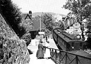
Hameln / Klüt stop at the Klüttunnel in the 1920s


Web links
- Audio report about the Klüt on Radio Aktiv (4:14 minutes)
Individual evidence
- ↑ Hameln's local mountain should be a magnet for visitors ( memento of the original from December 31, 2014 in the Internet Archive ) Info: The archive link was inserted automatically and has not yet been checked. Please check the original and archive link according to the instructions and then remove this notice. in: Hello Sunday, July 6, 2012
- ↑ The mountain fortress from 1760 to 1808 at hamelner-geschichte.de, accessed on December 28, 2014
- ↑ The Finkenborn
- ^ Zoo am Klüt Hameln - Discussion with photos in the Tiergarten Forum, 2008. Accessed on November 3, 2015 .
- ^ The railway bridge and the Klüttunnel at hamelner-geschichte.de, accessed on December 28, 2014
- ↑ Tourism on the Klüt - there is more . In: Dewezet, October 20, 2010
Coordinates: 52 ° 5 ′ 42.2 " N , 9 ° 20 ′ 18.6" E