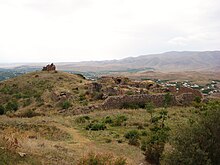
Havuts Tar monastery
The monastery Havuts Tar (also: Armenian Հավուց Թառ Վանք Hawuz Tar Wank ; "Allerheiligenkloster") is a former convent of the Armenian Apostolic Church in the Armenian province of Kotayk . The origins of the monastery go back to the 11th to 13th centuries. In 1679 it was destroyed by an earthquake. Today it is a ruin.
location
The monastery is located in the Chosrow reserve . There it was built on the top of a hill on the left bank of the Azat River . On the other bank of the river are the villages of Goght and the small town of Garni . The Temple of Garni is also within sight .
Building description
The monastery complex is surrounded by defensive walls. Access to the monastery is through an arched entrance on the southeast corner. It consists of two churches in the center (the relatively intact main church and the ruins of another church adjoining it) in the center of the area, the ruins of a Gawit and the ruins of other buildings. Vaulted guest rooms and a large underground chamber on the south wall, which probably served as a manuscript library, have been partially preserved.
The main church Surb-Amenaprkich-Kirche is a cross -domed church . The central church space is crowned by a (today destroyed) dome with a cylindrical drum . It stands on a hill west of the monastery. The building is richly decorated with stone carvings. Your only access is to the west of the structure. There are chapels in the four corners of the building. The apse on the east wall has two small ornamental niches and a window. In the center of the apse is the altar on an elevated position. Some inscriptions have been preserved on the southern and western outer walls.
Most of the buildings were built between the 12th and 14th centuries. They are made of red and black tuff stones. A rich fund of inscriptions and stone carvings from the early days of the monastery has been preserved in the monastery.
On the way to the monastery and on the area itself, there are many khachkars (artistically carved memorial stones with a relief cross in the middle, which is surrounded by geometric and plant motifs). They are considered to be particularly valuable in terms of art history. One of them is on display in the Yerevan Historical Museum as one of the ten most important khachkars in the country.
history
Havuts Tar was one of the most important religious and cultural centers of Armenia in the early Middle Ages.
On the west side outside the monastery on a hill is the main church Surb Amenaprkich ( Savior Church ). According to the historian Mkhitar Airivanetsi, an Armenian prince named Gevorg Marzpetouni had it built in the 10th century. In the 11th century it was apparently badly damaged because it was rebuilt in 1013 by the young Grigor Pahlavuni (approx. 990-1058), son of Lord von Bjni. After the conquest of Armenia in the Byzantine Empire , Grigor made his career, Megas Doux became governor of the province of Edessa and went down in history as "Grigor Magistros". Grigor also founded the Ketcharis monastery in Tsaghkadzor .
There is a legend associated with the church, according to which, during an invasion of the Seljuks , the head of the monastery managed to convince the enemy that he should spare those who find refuge in the church. Many doomed people then went to the monastery, left it through a secret passage and were thus saved.
The Chapel of St. Karabet ( John the Baptist ) was built in 1213.
In 1679 the entire monastery complex was destroyed by an earthquake. Catholicos Astvatsatur Hamadantsi commissioned the construction of the Surb Karabet Church in 1724. For its construction on the ruins of the chapel of the same name, stones from the ruins of the Gawit and the Surb-Amenaprkich Church were used. The church, however, remained unfinished. In the 18th century a wall was built around the main buildings of the monastery complex. Today the monastery is in ruins. The dome of the church, part of its rear wall and the chapel have been destroyed. Some restoration work took place in the early 20th century.
Web links
Individual evidence
- ↑ a b c d e f g Havuts Tar, Garni, Armenia | World Building Directory | Buildings. Retrieved November 16, 2017 .
- ↑ a b c d Havuts Tar Monastery - Armeniapedia.org. Retrieved November 16, 2017 . ((Copy from: Raffi Kojian: Rediscovering Armenia: an archaeological / touristic gazetteer and map set for the historical monuments of Armenia. Tigran Mets, Yerevan 2001, ISBN 99930-52-28-0 ) pp. 53/54
- ^ Kojian, Raffi .: Rediscovering Armenia: an archaeological / touristic gazetteer and map set for the historical monuments of Armenia . 2nd ed. Mattit, [Yerevan] 2005, ISBN 99941-0-121-8 , pp. 90 .
Coordinates: 40 ° 7 ′ 22.7 ″ N , 44 ° 46 ′ 7.9 ″ E


