
Kniepass (Saalach)
| Kniepass ( valley pass ) |
|||
|---|---|---|---|
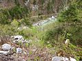
 Knee pass from the direction of Unken |
|||
| Compass direction | North | south | |
| height | 558 m above sea level A. | ||
| state | Salzburg | ||
| Waters | Saalach | ||
| Valley locations | Toads | Lofer | |
| expansion | Loferer Strasse (B178) | ||
| Built | Bronze Age settlement traces | ||
| Mountains | Reiter Alpe | ||
| Map (Salzburg) | |||
|
|||
| Coordinates | 47 ° 38 '2 " N , 12 ° 43' 40" E | ||

The Kniepass is located in the municipality of Unken in the state of Salzburg in Austria . The Kniepass is a valley pass at 558 m above sea level.
An important connecting road, the Loferer Straße (B 178), which connects Lofer and Unken, leads over the pass . Above the pass there is a historically interesting fortification, the Kniepass fortress .
Kniepass with Saalachtal

Kniepass from the direction of Lofer


Web links
Commons : Kniepass - collection of images, videos and audio files