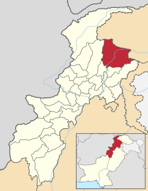
Kohistan
| Kohistan District | |
| State : |
|
| Province : | Khyber Pakhtunkhwa |
| Founded : | October 1, 1976 |
| Seat : | Dassu |
| Coordinates : | 34 ° 41 ' N , 73 ° 2' E |
| Area : | 7th 492 km² |
| Residents : | 784,711 (2017) |
| Population density : | 105 inhabitants per km² |
| Time zone : | PST ( UTC + 5 ) |

|
|
Kohistan ("Land of Mountains") is a mountain landscape and a former administrative district in Pakistan in the province of Khyber Pakhtunkhwa . The seat of the district administration was the city of Dassu .
location
Kohistan is in the northeast of Khyber Pakhtunkhwa. The former district bordered Ghizer and Diamer in the north and northeast , Manshera in the southeast, Batagram in the south and Shangla and Swat in the west .
geography
Kohistan extends over a mountainous country in the far west of the Himalayas . The Indus divides Kohistan into the western Swat Kohistan and the eastern Hazara Kohistan . The Karakoram Highway runs along the banks of the Indus through Kohistan. The district of Kohistan covered 7492 km².
climate
The climate in Kohistan is characterized by moderately warm summers and very cold winters. In winter, large amounts of snow fall in the higher areas.
history
On October 1, 1976, Swat Kohistan and Hazara Kohistan were merged to form the Kohistan District. On October 8, 2005, a strong earthquake struck the area , causing great damage in the district. In 2012, four women and two men were murdered after dancing to a tribal song. In 2014 the district was divided into two parts - Lower and Upper Kohistan .
Demographics
Between 1998 and 2017 the population grew by 1.97% annually. 100% of the population lived in rural areas. 434,956 men, 349,746 women and 9 transgender people live in 101,911 households , resulting in a gender ratio of 124.4 men per 100 women, which is a common surplus for Pakistan.
Kohistan's literacy rate is among the lowest in Pakistan, around 20%.
| year | population |
|---|---|
| 1972 | 204,521 |
| 1981 | 465.237 |
| 1998 | 472,570 |
| 2017 | 784.711 |
Ethnic groups
The tribes in Swat Kohistan are divided into two groups: Manzar and Money . The tribes of Dubair , Kandia and Ranolia belong to the Manzar , while the tribes of Banked , Jijal , Pattan , Kayal and Seo belong to the Money . The most important tribes on the left bank of the Indus are Koka Manke Khel and Darram Khel .
Web links
Individual evidence
- ↑ a b c d e f District Profile Kohistan (PDF 667 KB) Earthquake Reconstruction and Rehabilitation Authority - ERRA. Retrieved March 25, 2017.
- ^ Kohistan District Demographics . Government of Khyber Pakhtunkhwa. Retrieved March 25, 2017.
- ^ Rina Saeed Khan: Murders in Paradise. January 8, 2013, accessed June 22, 2019 .
- ^ Lower Kohistan . Government of Khyber Pakhtunkhwa. Retrieved March 25, 2017.
- ↑ DISTRICT WISE CENSUS RESULTS CENSUS 2017. August 29, 2017, accessed May 30, 2019 .
- ↑ Pakistani Districts wise Population Census 2017. Accessed May 30, 2019 .
- ↑ Archived copy . Archived from the original on November 13, 2010.
