Kollmannspark
| Kollmanspark | |
|---|---|
| Park in Neu-Ulm | |

|
|
|
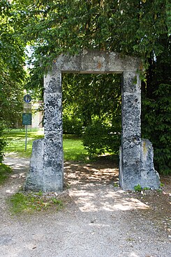
Entrance portal to Kollmannspark, the year 1910 is carved on the archway |
|
| Basic data | |
| place | New Ulm |
| Created | 1900-1910 |
| Newly designed | 1994-1996 |
| Surrounding streets | Schützenstrasse (west), Turmstrasse (north), Margarethenweg (east); the Philosophenweg leads directly to the park from the north |
| Buildings | Neu-Ulm water tower , pumping systems |
| use | |
| User groups | Foot traffic ; Leisure , events |
| Technical specifications | |
| Parking area | 6500 m² |
The Kollmannspark is a small public city park in the urban area of Neu-Ulm . It is bounded on one side by the ramparts of the former city fortifications.
history
The Kollmannspark was created in 1910 in honor of the Mayor of Neu-Ulm at the time , Hofrat Josef Kollmann (Mayor from 1885 to 1919), who had made a great contribution to expanding the infrastructure of the young, growing Bavarian city. After the Second World War, the park became overgrown. It was only redesigned between 1994 and 1996 as part of structural renovation measures.
In the 21st century, the Kollmannspark serves the population as a local recreation area. Since 1997 it has also hosted the annual public family festival in Neu-Ulm.
description
The 6,500 m² Kollmannspark is located on the western edge of downtown Neu-Ulm. It is part of a long contiguous green belt, which extends along the glacis equipment covers, a part of the former federal fortification Ulm .
Optical main attraction of the park is the Kollmann under monument protection standing Neu-Ulm water tower , the former symbol of of Councilor Kollmann initiated modern urban development and at the same time landmark of the city of Neu-Ulm. Several water-bound paved footpaths lead through the park with its well-tended lawns and large deciduous trees that are now more than a hundred years old . At least two trees are particularly marked by the boulders placed at their feet, each of which was “planted” on May 9, 1905: a Schiller linden and a Schiller beech . On the southwest and south side, the transitions from Kollmannspark to the neighboring parks of the Glacis facilities are flowing.
The Kollmannspark is accessible via Turmstrasse, Schützenstrasse and the adjacent “Kollmannspark” path. Entry to the park is free and possible at any time of the day or night.
Monument protection
The Kollmannspark is included in the list of monuments of the Bavarian State Office for the Preservation of Monuments as one of eight individual components of the main wall of the formerly largest fortress in Europe, the Federal Fortress of Ulm , and is therefore also under monument protection (monument no. D-7-75-135-1).
Individual evidence
- ↑ The Kollmannspark , homepage of the city of Neu-Ulm , nu.neu-ulm.de, accessed on February 23, 2016.
- ↑ family celebration Neu-Ulm , homepage of the city of New Ulm nu.neu-ulm.de, accessed on February 23 2016th
- ↑ Seen and photographed on May 23, 2019.
- ↑ List of monuments of the Bavarian State Office for Monument Preservation , geodaten.bayern.de ,. pdf, pp. 7 and 8, accessed on February 23, 2016
Coordinates: 48 ° 23 '21.4 " N , 9 ° 59' 36.9" E
