Korakou
Korakou ( Κοράκου ravens (hill) ) is an archaeological site about 1 km west of the modern city of Corinth . This is probably the Bronze Age port of prehistoric Corinth , which according to tradition used to be called Ephyra . Korakou was excavated by Carl Blegen from 1915 to 1916 . It was the first excavation site in which all three epochs of the Helladic period were excavated and the sequence of the epochs could be determined.
location
The archaeological site is located on a hill about 1 km east of the ancient port of Lechaion . The terrain drops steeply 35 m in the north. The modern road from Corinth to Lecheo and the old route of the narrow-gauge railway to Patras run below the hill . There is also an oenological laboratory there. In the south the hill drops only gently and rises about 15 m above the southern plain.
chronology
Blegen found a total of 11 layers of settlement. The oldest finds come from the Early Helladic period (FH, 3250–2000 BC). This time is represented by an approximately 2 m thick layer directly above the conglomerate rock . Pottery shards with seal impressions showing a spiral pattern prove the contact of the inhabitants with the Cycladic culture . The lower six layers of the epoch were separated from the following two by a layer of ash. Since the original varnish ceramics appeared for the first time after the fire disaster , this must have taken place in the FH II era.
The Middle Helladic (2000–1550 BC) consists of three main layers with a total thickness of 1–1.40 m. The characteristic pottery consists mainly of gray and yellow Minysh and local Black Minysh ceramics (also known as Argive Minysh) and vessels from the Cyclades and Crete. For MH III, continental ceramics appear, which imitate the MM III ceramics. The change to the Late Helladic (SH I – III, 1550–1360 BC) is seamless. It is represented by a 0.40–2.10 m thick layer. While the Grauminy ceramic has almost completely disappeared, the Ephyrian ceramic, a style derived from the Miny ceramic with elements of Mycenaean art, appears. A representative of this genus is the so-called Ephyra bowl .
Based on these findings, Blegen divided the Helladic period into the periods FH I, FH II, FH III, MH I, MH II, MH III and SH I, SH II, SH III, analogous to the Minoan culture.
description
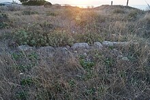
The area excavated so far has a size of about 80 m in the west-east and 40 m in the north-south extension.
Only a few architectural parts are known from the Early Helladic period, as only individual test cuts were made to this depth. It is known that the houses had stone foundations. On top of these, the walls made of unfired clay bricks measuring 0.19 × 0.19 × 0.10 m were erected. The houses were built in the same way in the following epochs. In addition, an artificially created depression, a so-called Bothros , was discovered from this time. Since the clay with which the depression was lined was not burned, Blegen assumed that the Bothros was not used to make burnt offerings, but to store food.
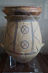
Two house floor plans in the eastern part of the excavation site are known from the Middle Helladic period. House F is an apsidial house. It had a small anteroom and a 6,20 m long main room with a hearth. Another room was in the apse . Due to a lack of finds, the function of the last room could not be determined. The second house B is a small, rectangular building. Blegen also discovered two graves from the Middle Helladic period. These are typical burials of children under the floor of the still inhabited houses. A burial was found at a depth of 1.10 m. A two-year-old boy and a baby were buried in a pithos , which was closed with a large bowl. Since the two vessels could not be completely reconstructed from the found fragments, Blegen assumed that damaged clay vessels were used for the burial for economic reasons. Another grave contained a child who was buried in the fetal position.
Several houses from the Late Helladic period have been explored. The foundation walls of House M are to the west of House B. It had an irregularly shaped megaron, about 5.50 × 7.75 m. It had a floor made of tamped clay, a stove and a column that supported the roof. The room to the north may have belonged to this building. House H, north of House M, consisted of a portico , a megaron measuring 6.50 × 4.60 m and a back room. Blegen was able to identify two construction phases of this house. To the west of House M was House L, it had a portico with a central column, a small anteroom, a megaron with a stove and two columns and a back room. The foundation walls of the large house K are to the west of house L. It was destroyed, restored and rebuilt several times. It was built for SH I and was inhabited until SH III. To the west of house K was the smallest house from this period that had been discovered so far. It consisted of a portico, vestibule and megaron. A raised platform was found in one corner of the megaron, which may have served as a bed. To the north of it was the large house S, in which bronze pieces were found. Since the building structure was badly damaged, it was not possible to draw up a complete plan of the house.
House P, in the western part of the site, was entered through an anteroom. To the north behind was a megaron about 8 × 8 m in size. In addition to a stove there was a batyle and an altar . To the west of the anteroom was a narrow, elongated room that presumably had a staircase that led to the upper floor. There were two adjoining rooms north of the megaron. The western one probably served as a bedroom and the eastern one as a kitchen. A doorstep 1.74 m long and 0.87 m wide was discovered north of house P and a round ash altar with a diameter of 0.95 m. 3.75 m south of it. Carl Blegen suspected that the remains of the building near the northern slope could possibly be the palace of Korakou and that this extended even further to the north. In the Mycenaean period, the hill is said to have continued about 8-10 m further north. This land mass, which is missing today, was eroded away.
In the far west of the excavation site, a 10 m long piece of the fortification wall was discovered. It was made of small stones and was about 2 m thick and 1.70 m high. A tower measuring 10 × 9.55 m was integrated into the wall.
To the north of the northeastern area of house P, three children's graves from the late Helladic period were discovered. They were simple pits in which the deceased were deposited. While grave I had rich additions such as a pearl necklace made of glass paste and numerous ceramic vessels, only two vessels were found in grave II and no additions at all in grave III.
The lion from Korakou
In 1995 a column with the capital of a funerary monument was found near the Bronze Age settlement . Tomb robbers got ahead of the archaeologists and recovered the lion sculpture that was originally built on it. In 2001 the police were finally able to seize this sculpture and hand it over to the Archaeological Museum of Corinth . The grave monument dates from 550-540 BC. BC, was originally 3.50 m high and painted with black and red paint. To whom the grave monument was dedicated is unknown. In connection with this monument, the indication of Pausanias about the grave of the hetaera Lais (4th century BC) is often cited. He reported that her grave was in front of the city wall and that there was a sculpture of a female lion tearing a ram on it.
literature
- Carl Blegen : Korakou: a prehistoric settlement near Corinth , Boston and New York 1921 ( online )
- Konstantinos Kissas: Ancient Corinthia. Athens 2013, ISBN 978-960-6849-37-4 , p. 43
- Guy DR Sanders, Jennifer Palinkas, Ioulia Tzonou-Herbst, James Herbst: Ancient Corinth: Site Guide , Athens 2018, pp. 174-175
Web links
Individual evidence
- ^ Re-Exhibiting Corinth: A New Face For The Museum
- ^ Pausanias: Travels in Greece , 2, 2, 4
Coordinates: 37 ° 56 ' N , 22 ° 54' E


