Koro (island)
| Koro | ||
|---|---|---|
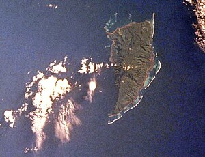
| ISS picture by Koro | ||
| Waters | Koro lake | |
| Archipelago | Lomaiviti Islands | |
| Geographical location | 17 ° 19 ′ S , 179 ° 25 ′ E | |
|
|
||
| length | 16 km | |
| width | 9 km | |
| surface | 108.9 km² | |
| Highest elevation | Mount Kuitarua 522 m |
|
| Residents | 4500 (2007) 41 inhabitants / km² |
|
| main place | Nakodu | |
Koro is a volcanic island in the center of the island state of Fiji . Administratively, the island belongs to the Lomaiviti Province in the Eastern Division . It is one of the Fiji Islands discovered by William Bligh in May 1789 after the mutiny on the Bounty while sailing in the barge .
geography
Koro is 100 km east of Viti Levu , the largest island in Fiji, and 50 km south of Vanua Levu . It is named after the Koro Sea , in the north-western area of which it lies, and forms the group of Lomaiviti Islands with other islands in this region . Koro is about 16 km long, up to 9 km wide and has an area of about 109 km². The island consists of numerous basaltic cinder cones and reaches a height of 522 m above sea level. Koro is, with the exception of the southwest, a coral reef offshore. Around 4500 people live on the island; the largest places on the island are Nakodu in the southeast, Nasau in the east and Nacamaki in the northeast. Immediately north of Nakodu is the Koro Airport ( IATA code: KXF, ICAO code: NFNO), the only airport on the island.
Web links
- Koro in the Global Volcanism Program of the Smithsonian Institution (English)
- Map of Koro
Individual evidence
- ↑ koroisland.org , accessed April 30, 2017 (English)
- ↑ Koro 2014 Handbook, p. 5 ( Memento of the original dated February 22, 2016 in the Internet Archive ) Info: The archive link was inserted automatically and has not yet been checked. Please check the original and archive link according to the instructions and then remove this notice. , accessed on April 30, 2017 (PDF 1.4 MB; English)
- ↑ UNEP Islands Directory (English)
- ^ National Geospatial-Intelligence Agency: Sailing Directions (enroute), Pub. 126, Pacific Ocean (PDF; 4.84 MB) (accessed October 12, 2010)

