Viti Levu
| Viti Levu | ||
|---|---|---|
| Relief by Viti Levu | ||
| Waters | Pacific Ocean | |
| Archipelago | Fiji Islands | |
| Geographical location | 17 ° 48 ′ S , 178 ° 0 ′ E | |
|
|
||
| length | 146 km | |
| surface | 10,531 km² | |
| Highest elevation |
Tomanivi 1324 m |
|
| Residents | 580,000 55 inhabitants / km² |
|
| main place | Suva | |
| Aerial view of Suva | ||
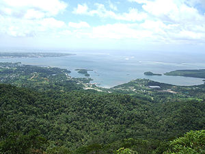
Viti Levu [ ˈβitʃi ˈleβu ] is the 10,531 square kilometer main island of the Fiji Group in the South Pacific .
The island is of volcanic origin and extends from north to south for about 106 kilometers and from east to west for about 146 kilometers. Together with the neighboring island of Vanua Levu , about 70 kilometers to the north, which is 5587 square kilometers in size, it takes up almost 90% of the land area of the Republic of Fiji Islands . Its capital Suva is also the largest city of Viti Levu. Other large cities are Ba , Lautoka , Nausori , Rakiraki, Sigatoka and Nadi , which has an international airport . With around 580,000 inhabitants, around three quarters of the total population of Fiji live on Viti Levu.
Administratively, the eastern part of Viti Levus belongs to the Central Division , while the western part belongs to the Western Division of the country.
Web links
Individual evidence
- ↑ UNEP Islands Directory (English)
- ↑ UNEP Islands Directory (English)


