Viti Levu Group
| Viti Levu Group | ||
|---|---|---|
| Map of Fiji, the Viti Levu group in the west | ||
| Waters | Pacific Ocean | |
| archipelago | Fiji | |
| Geographical location | 17 ° 48 ′ S , 178 ° 0 ′ E | |
|
|
||
| Main island | Viti Levu | |
| Total land area | 10.453 km² | |
| Residents | 661,997 (2007) | |
| Satellite image 2001 | ||
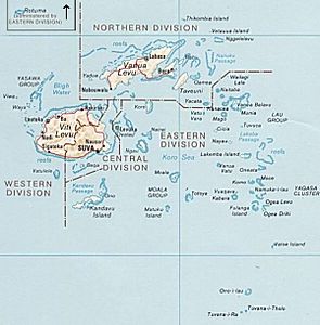
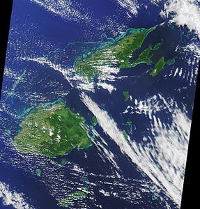
The Viti Levu Group is a group of islands in the South Pacific belonging to the Melanesian state of Fiji . It consists of two of Fiji's administrative divisions , the Central Division and the Western Division .
The main island is Viti Levu , other inhabited islands and atolls are: Bau , Beqa , Leleuvia , Naigani , Nananu-i-Cake , Nananu-i-Ra , Nukulau and Vatulele .
Some archipelagos near Viti Levu, such as the Lomaiviti Archipelago , Mamanuca and the Yasawa Islands , are considered to be outlying and are usually treated as separate island chains.
The total area is 10,453 km², the population for the Central and Western Division according to the 2007 Census: 661,997 inhabitants (1996: 574 801).
Further offshore, generally uninhabited islands are:
- Bekana
- Bounty Island
- Laucala
- Macuata
- Makuluva
- Malake
- Malolo
- Malolo Lailai
- Mana
- Naqara
- Nasoata
- Ndrala
- Nukuvutivuti
- Omini
- Qalito
- Qoma
- Qata
- Tawainave
- Telau
- Tivua
- Tovu
- Tovu Lailai
- Treasure Island
- Valolo
- Vatia Lailai
- Vio
- Viwa
- Yanuca
- Yawalau
Web links
- Fiji Islands Bureau of Statistics: 2007 Census of population and housing (PDF; 322 kB)
- Detailed map of Fiji (PDF; 6.6 MB)


