
Yasawa Islands
| Yasawa Islands | ||
|---|---|---|
 |
||
| Waters | Pacific Ocean | |
| archipelago | Fiji Islands | |
| Geographical location | 16 ° 55 ′ S , 177 ° 20 ′ E | |
|
||
| Number of islands | 20th | |
| Total land area | 135 km² | |
| Residents | 1120 | |

The Yasawa Islands , old name: Ya-Asaua Group ( Wilkes ), are a sparsely populated archipelago in the southern Pacific Ocean , which politically belongs to the island state of Fiji .
geography
The archipelago extends over 90 kilometers off the northwest coast of Viti Levu . To the south is the Mamanuca Archipelago. The Yasawas consist of seven main islands with inhabited villages and numerous small islets without settlements. However, some of them have exclusive island resorts with hotel complexes. The largest island is Yasawa, which also gave the group its name.
Compared to the neighboring islands of Viti Levu and Vanua Levu , which tower over 1000 m , the Yasawas are significantly lower. The highest point is the Batinareba on the island of Waya with 579 m. The landscape is hilly, with a more or less extensive coastal lowland. Some of the small islets, especially in the west of the island chain, are low atolls that rise only a few meters above the sea surface.
climate
The long-term monthly average temperature is 22 ° C for July and 26 ° C for January. The southeast trade winds bring moisture, mainly between November and April, but the lower Yasawas benefit from it only to a relatively small extent. The climate is significantly drier than on the windward side of the large and high Fiji Islands.
From time to time the archipelago is hit by tropical cyclones. In March 1997, cyclone "Gavin" devastated the northern Yasawa Islands and in December 2012 cyclone "Evan" caused great damage.
geology
The Yasawas and the southern part of neighboring Viti Levu consist of 50 million year old volcanic rocks from the Eocene , while in the central western and eastern parts of Viti Levu there is mainly much younger andesite from the Pliocene .
flora
The native flora is oriented to the west, the Fiji Islands share over 90% of the species with New Guinea to the west . The remaining 10% are largely endemic . Birds and bats in particular served as carriers of the plants, but also periodically occurring strong winds and ocean waves.
The areas not used for agriculture are mostly covered by dry forest, which, in contrast to the main islands of Fiji, is largely undisturbed, especially on the unpopulated, small islands.
The dry forest is seasonal, because in the southern summer months it is supplied with more moisture than in the winter months. The forest is mainly composed of Dacrydium nidulum , a conifer from the stone slice family , and Fagraea gracilipes , a tree species endemic to Fiji, whose hardy wood was used by the indigenous peoples to build canoes. Other common plants are Pandanus sp. , the light walnut ( Aleurites moluccana ) and various figs ( Ficus sp. ). The vegetation near the coast is interspersed with coconut palms . In the meantime, however, the casuarina ( Casuarina equisetifolia ) with robust grasses is increasingly found as an undergrowth, a result of the slash and burn . The spread of "talasiqa" (pronounced talasinga, a Fiji expression for sun-burned land), an anthropogenic grassland without shady trees , is also favored by the slash and burn .
On some uninhabited islands, for example on Nanuya Lailai, there are extensive groves of coconut palms, which are cultivated and harvested by the inhabitants of the neighboring islands. Even in the 19th century there are said to have been more trees of the genus Santalum on the islands , but the coveted and expensive sandalwood was marketed to China .
Islands
- Drawaqa
- Kuata
- Matacawa Levu with the village of Vuake
- Nacula with the villages of Nasisili (also Sisili) and Nacula
- Nanuya
- Nanuya Balavu
- Nanuya Lailai
- Nanuya Levu
- Nanuya-i-Ra
- Nanuya-i-Yata
- Narara
- Naukacuvu
- Naviti with the villages of Soso, Muaira, Kese, Malevu, Marou, Somosomo, Nasoqo and Gunu
- Sawa-i-Lau
- Tavewa
- Tiliva
- Waya with the villages of Yalobi, Wayalevu and Natawa
- Waya Lailai
- Wayasewa with the villages of Naboro, Yamata and Namara (now a hotel settlement)
- Vawa
- Viwa
- Yaqeta with the village of Matayalevu
- Yasawa with the villages of Tamusua, Nabukeru, Teci, Bukama and Yasawairara,
- Yawini
Picture gallery

Teci on Yasawa, damage caused by cyclone "Gavin"

Kava ceremony in Teci village on Yasawa
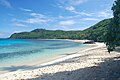
Beach on the island of Waya

Beach on Nanuya Lailai
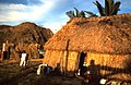
Residential house on Matacawa Levu


history
prehistory
The early history of the Yasawas is largely in the dark as the Fijis did not develop a script. The research is therefore based exclusively on the ethnological evaluation of oral traditions and on archaeological findings.
The inhabitants of the Yasawas belong to the Melanesian population group. Some of the traditional myths report that the islands were settled from Samoa or Tanna , while others claim that refugees from Tonga were the first settlers. An initial settlement of the nearby Viti Levu is more likely. When the first people arrived on the Yasawas has not been conclusively clarified. Radiocarbon dates from the sites evaluated so far reach back to approx. 800 BC. BC back.
At first, the settlers lived in caves and rock overhangs near the coast. Then they set up small settlements close to the beach and soon organized themselves into island-specific tribal societies .
In the second half of the 18th century, the small but densely populated island of Bau on the east coast of Viti Levu was able to secure a dominant position in the Fiji archipelago. Bau's warriors also conquered the northern Yasawa Islands. At the same time, the southern Yasawa Islands came under the hegemony of the Lawa Kingdom of Malolo Island, the largest island in the Mamanuca Archipelago.
The early European visitors describe the inhabitants of the Yasawa Islands almost in unison as "warlike savages" and "cannibals". The finds of numerous fortresses with earth terraces and a ring moat , as we know them similarly from the Neolithic cultures of Europe, confirm the oral traditions about a militant social order with countless tribal wars.
The tribal myths and records of Europeans tell of cannibalism in the Yasawa Islands. In the meantime there are also archaeological findings. The remains of food were analyzed in excavated rubbish heaps on the island of Waya. Among the remains of fish (around 50%) and other marine animals, the avifauna , chickens and the Pacific rat , the archaeologists also found numerous human bones, some of which were crushed. The findings so far point to exocannibalism, to the consumption of defeated enemies, in a period between 700 and 500 BC. Chr.
European discovery
The British navigator William Bligh discovered the Yasawas for Europe in 1789. The mutineers of the Bounty had abandoned Bligh and 18 crew members in front of Tofua in the 7.5 m long launch . In the open boat, the sailors sailed north-westerly through the northern yasawas. Despite the lack of water and food, the men did not dare to go ashore on one of the islands for fear of cannibals . Regardless of the exertion, Bligh drew a map and carefully described in his notes the area crossed with its dangers to shipping, the islands, reefs and rocks. The region between Vanua Levu and the Yasawas is now known as "Bligh Water" by ocean sailors.
Another early visitor was British merchant captain Henry Barber, who was involved in the Pacific trade in salt meat , pelts, sugar, rum and calico . On the route from Australia to China, he crossed the Yasawa Islands with his Schnau Arthur coming from the west. Before Waya, the Arthur was attacked by several war canoes full of warriors. Barber was able to repel the attack with the ship's rotating guns and with small arms. On April 26 and 27, 1794, the Arthur anchored on the west coast of Viti Levu and Barber had another argument with the warlike locals, in which several islanders were killed and two crew members were wounded.
We owe the first complete map of the Yasawa Islands to the United States Exploring Expedition (US Ex Ex) under the leadership of Charles Wilkes . Two ships of the expedition, USS Vincennes and USS Peacock , cruised in the waters of the Yasawas for several days in August 1840 to survey and map the islands. Wilkes went ashore on three islands: Naviti, Waya (Waia) and Yasawa. All three were inhabited and the Americans received a warm welcome. On Yasawa, Wilkes saw a completely devastated village with devastated fields, the result of a tribal war that had only recently taken place.
Modern times
The Pacific War was not without consequences for the Yasawa Islands. They feared a Japanese invasion of New Zealand and wanted to fortify the Fiji Islands as an outpost. After the Royal New Zealand Navy had prepared the island of Viti Levu for defense with coastal cannons , anti-aircraft cannons , radar posts and the stationing of smaller warships as well as Catalina flying boats for patrol and submarine hunting in 1941 , the USA took over responsibility for them in 1942 Naval defense. In June 1942 the US Navy laid 700 sea mines around the Yasawas.
politic and economy

The archipelago now belongs politically to the province of Ba , the most populous of the 14 provinces of Fiji, in the Western Division of the island of Viti Levu. Although the heads of the villages are now democratically elected, coexistence is still based heavily on family relationships, the tribe, the clan and the (extended) family. The churches - Methodist and Wesleyan , Roman Catholic , Assemblies of God, and Seventh-day Adventists - are also influential.
The inhabitants of the Yasawa Islands live mainly from subsistence farming . In addition to fishing near the coast with a spear or net, mussels, crustaceans and mollusks are also collected. In the past - but less often today - fish were also caught with stone fish traps . An archaeological analysis of aerial photographs showed the remains of 65, in some cases very large, structures. Agriculture is a combination of horticulture, mainly tubers such as yams , sweet potatoes and cassava , as well as resource-saving tree use, for example breadfruit trees and coconut palms for copra production.
Commercial products are copra and woven mats to a small extent. Occasionally, fish, crustaceans and fruits are also delivered to the hotels.
The mainstay of the economy are now the exclusive resorts that have sprung up on some islands, with daily prices in the high three-digit dollar range. The guests are mainly US-Americans, Japanese, Australians and, more recently, also rich Chinese. However, the residents of the Yasawas hardly benefit from it. Only a few islanders have found sources of income directly or indirectly in tourism and hotel complexes.
Infrastructure

The islands themselves are poorly developed. There are no paved roads, no railways and no developed ports. Only a few villages are connected to one another by unpaved roads or footpaths. Supplies and local passengers mostly travel on the small coasters that call at the islands at irregular intervals. They also take the few Yasawas' goods with them. The ships are in the roadstead and the goods have to be reloaded into small boats.
A catamaran ferry operates daily between Port Denarau near Nadi and some of the Yasawa Islands . In the north of the island of Yasawa, near the village of Bukama, is the "Yasava Island Airport" ( IATA airport code : YAS, ICAO code : NFSW), just an unpaved runway without ancillary buildings that is not served by scheduled services. A fast, but too expensive means of transport for the islanders is the seaplane from Port Denarau or the helicopter from Nadi Airport . The most comfortable way for tourists to explore the Yasawas are multi-day mini cruises from Denarau, for example with “Blue Lagoon Cruises”.
In the larger villages there are primary schools, secondary schools only on the island of Naviti or on Viti Levu.
The villages do not have a public electricity network or a central water supply. However, the comfortable hotel complexes are equipped with all the infrastructure the tourists want. Electricity is generated with diesel generators , and the water is often supplied with treated seawater. Satellite phones and internet connections are usually available in the resorts.
Trivia
Nanuya Levu Island (or Turtle Island) was the location of the 1980 Hollywood film The Blue Lagoon by director Randal Kleiser with Brooke Shields and Christopher Atkins .
Individual evidence
- ^ Nelles Map: South Pacific Islands. ISBN 978-3-86574-068-7 .
- ↑ Daniel Bickel, Neal Evenhuis: The NSF Fiji Terrestrial Arthropod Survey. In: Bernice P. Bishop Museum Occasional Papers. Vol. 82, 2005, pp. 3-25.
- ↑ Mark Kersemakers: Cyclone Report - Tropical Cyclone Gavin. Fiji Meteorological Service, Nadi 1998.
- ^ Cyclone Evan hits Fiji. In: New Zealand Herald. 17th December 2012.
- ^ A b c Dieter Mueller-Dombois, F. Raymond Fosberg: Vegetation of the Tropical Pacific Islands. Springer-Verlag, Berlin 1998, ISBN 0-387-98313-9 .
- ^ Ronald Albert Derrick: The Fiji Islands - a geographical handbook . Government Press, Suva 1957, p. 6.
- ↑ Basil Thomson: The Fijians: A Study of the Decay of Custom. William Heinemann, London 1908, p. 22.
- ^ A b c d Terry L. Hunt et al.: A Preliminary Report on Archaeological Research in the Yasawa Islands, Fiji. In: Domodomo - Fiji Museum Quarterly. Vol. 12 (2), Suva 1999, pp. 5-43.
- ↑ Caroline Alexander: The Bounty - The true story of the mutiny on the Bounty. Berlin Verlag, Berlin 2004, ISBN 3-8270-0163-3 , p. 201.
- ^ William Bligh: A Voyage to the South Sea, undertaken by command of His Majesty, for the purpose of conveying the bread-fruit tree to the West Indies, in His Majesty's Ship the Bounty, commanded by Lieutenant William Bligh . George Nicol, London 1792
- ^ Fergus Clunie: Fijian Weapons and Warfare . In: Fiji Museum Bulletin. 2, Suva 1977, p. 79.
- ^ Wilfried Schuhmacher: Henry Barber, Merchant, Captain of the Pacific . In: Nora Marks Dauenhauer , Richard Dauenhauer, Lydia T. Black: Russians in Tlingit America. University of Washington, Seattle 2008, ISBN 978-0-295-98601-2 , p. 211.
- ^ Charles Wilkes: Chart of the Viti Group or Feejee Islands, 1840. In: Atlas. Narrative of the United States Exploring Expedition During the Years 1838, 1839, 1840, 1841, 1842. By Charles Wilkes, USN Commander Of The Expedition, Member Of The American Philosophical Society, Etc., Lea & Blanchard, Philadelphia 1845.
- ^ Charles Wilkes: Narrative of the United States Exploring Expedition During the Years 1838, 1839, 1840, 1841, 1842. By Charles Wilkes, USN Commander Of The Expedition, Member Of The American Philosophical Society, Etc. Lea & Blanchard, Philadelphia 1845, pp. 271-277.
- ^ Robert Lowry: Fortress Fiji - Holding the Line in the Pacific War. Sutton (Australia) 2006, ISBN 0-9775129-0-8 , p. 34.
- ↑ Tourism Fiji: Yasawa Islands , accessed February 15, 2016 (English).