
Kosciuszko Road
| Kosciuszko Road | ||||||||||||||||
|---|---|---|---|---|---|---|---|---|---|---|---|---|---|---|---|---|
| Basic data | ||||||||||||||||
| Operator: | Roads and Maritime Services | |||||||||||||||
| Start of the street: |
Alpine Way , Barry Way Jindabyne ( NSW ) ( 36 ° 25 ′ S , 148 ° 37 ′ E ) |
|||||||||||||||
| End of street: |
Charlotte Pass ( NSW ) ( 36 ° 26 ′ S , 148 ° 20 ′ E ) |
|||||||||||||||
| Overall length: | 47 km | |||||||||||||||
| of which in operation: | 38 km | |||||||||||||||
|
States : |
||||||||||||||||
 |
||||||||||||||||
|
Course of the road
|
||||||||||||||||
The Kosciuszko Road is a tourist road in the southeast of the Australian state of New South Wales . It connects the Alpine Way and the Barry Way in Jindabyne with the Charlotte Pass ski resort .
course
The road leaves Jindabyne to the north and initially runs along the west bank of Lake Jindabyne . Then she turns west and enters Kosciuszko National Park . After about 20 km, an access road branches off to the north to the winter sports resorts of Island Bend and Guthega , directly on the Snowy River , while Kosciuszko Road turns southwest and reaches Smiggin Holes . A little further, the road leads through the Perisher Valley ski resort and finally ends in the small settlement of Charlotte Pass below the pass of the same name.
Until 1982 the Kosciuszko Road was still passable from there 9 km to the summit of Mount Kosciuszko . Today this section of the route is closed to all motor vehicles for environmental reasons.
Importance and road conditions
Kosciuszko Road is the only access to the most famous winter sports areas in Australia. In winter, however, it is mostly snow-covered. The last 7 km from Perisher to Charlotte Pass are then closed, so that Charlotte Pass can only be reached with special, all-terrain buses or snowmobiles.
In the summer months, the road provides access to the ascent routes to Mount Kosciuszko and other mountains of the main ridge of the Snowy Mountains . The last section of the route, which is closed to motor vehicles, is one of the ascent routes to the highest mountain in Australia.
gallery

Statue of Sir Paul Edmund de Strzelecki in Jindabyne

Perisher, Australia's largest ski area, is accessible from Kosciuszko Road.
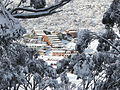
Charlotte Pass ski area from Kosciuszko Road in winter


source
Steve Parish: Australian Touring Atlas . Steve Parish Publishing. Archerfield QLD 2007. ISBN 978-1-74193-232-4 . P. 34
Individual evidence
- ↑ Kosciuszko National Park - How to get there | NSW National Parks . Environment.nsw.gov.au. June 21, 2012. Retrieved August 2, 2012.
- ^ Australian Alps National Parks - Kosciuszko and Jindabyne region . Australianalps.environment.gov.au. May 2, 2012. Retrieved August 2, 2012.