
Krøttøya
| Krøttøya | ||
|---|---|---|
 |
||
| Waters | Northern European Sea ( Andfjord ) | |
| Geographical location | 69 ° 3 ' N , 16 ° 32' E | |
|
||
| length | approx. 3.4 km | |
| width | about 1.7 km | |
| Highest elevation | Nordlystoppen (Kollen) 99 moh. |
|

Krøttøya is an inhabited island in the Andfjord in Norway . It belongs to the municipality of Harstad in the province of Troms og Finnmark .
Geography and infrastructure
Krøttøya is surrounded by the islands of Senja in the east, Bjarkøya and Grytøya in the south, Andøya in the west and Meløyvær in the north.
Krøttøya is inhabited, especially in summer when the many holiday homes are occupied, and catamarans run several times a day to the islands of Bjarkøy and Senja and to Harstad. A bridge connects Krøttøya with Meløyvær to the north.
Flora and fauna
During the winter season (October to March) large schools of herring reach the Andfjord, followed by orcas , humpback whales and fin whales . Sperm whales and pilot whales can be found year round.
history
The island was of great strategic importance during the Cold War . The Meløyvær fortress on the island would have a possible attack by the Soviet Navy in the supply lines and defenses of the Norwegian Army in northern Norway are to fend off. Fully occupied, up to 450 soldiers from the Norwegian armed forces were stationed on the island. The army only left the island in 2012, so visitors from outside today no longer need a security check. Some of the bunkers and military facilities are now privately owned. Valhall , a former barracks complex , was renovated in 2007 and is now a hotel .
Attractions
The main attractions are Viking graves and the National Museum fortress Meløyvær . The main activities are whale watching , eagle safaris, fishing, kayaking and diving.
gallery

Midnight sun from Nordlystoppen

Nordlystoppen (Kollen) 99 m, in summer

Meløyvær and Krøttøya from Nordlystoppen

View to the north from Nordlysvegen - Krøttøya

View from Meløyvær to Krøttøya; Andørja in the background
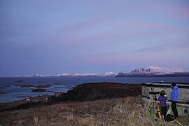
Whale explorer at work - Krøttøy

Former Viking settlement - Krøttøya

Gun B - Meløyvær Fortress


