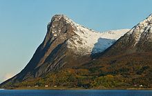
Grytøya
| Grytøya | ||
|---|---|---|
| Grytøya, view from Hinnøya | ||
| Waters | European Arctic Ocean | |
| Geographical location | 68 ° 55 ' N , 16 ° 32' E | |
|
|
||
| length | 22 km | |
| width | 12 km | |
| surface | 107.74 km² | |
| Highest elevation | Nona 1012 m |
|
| Residents | 454 4.2 inhabitants / km² |
|
Grytøya is an island in Fylke (Province) Troms og Finnmark in Northern Norway .
geography
Grytøya is located between the islands of Hinnøya in the south and Bjarkøya in the north and is surrounded by Toppsund in the south-west, the Andfjord in the west, Kvernsund in the north, and the Vågsfjord in the east. The island is about 22 km long from northwest to southeast and about 12 km wide from northeast to southwest. It has an area of 107.74 km² and a total coastline of around 62 km. The island is very mountainous, and the mountains rise almost vertically out of the sea, especially in the north and south-west. The highest peak is the 1012 meter high Nona. There are countless skerries in the Andfjord immediately west of the island .
administration
Administratively, Grytøya belongs to Harstad Municipality . Until January 1, 2013, 38 square kilometers on the northern side of the island were part of what was then Bjarkøy , which was then incorporated into Harstad.
Settlements and Transport
The population is falling; In 2001 there were 539 people living on Grytøya, down from 454 in 2012. The largest settlements on the island are the villages of Bessebostad in the southeast, Fenes on the east coast and in the northwest the fishing village of Grøtavær with a school and chapel. The island church is located southwest of Bessebostad in Lundenes in the extreme southeast; there is also the Grytøy open-air museum. The settlements in the south and east are connected by the provincial road Fv 867, which runs from Bjørna on the south coast along the east coast to the north. The road connection from Bjørna to Grøtavær in the northwest has only existed since July 1996, when the Fv 15 with a 3986 meter long tunnel , the Toppen tunnel under the 759 m high Toppen on the west coast, was completed. There are hardly any settlements and no road connections on the north coast.
The island can only be reached by ship: a car ferry goes from Stornes on Hinnøya over the approx. Three kilometer wide Toppsund to Bjørnå. There are ferry connections from Vikran in the northeast of the island to the neighboring islands of Sandsøya and Bjarkøya. The plan is to build a 3250 m long submarine tunnel between Grytøya and Bjarkøya and a bridge and dam connection from Grytøya to Sandsøya (900 m dam, 300 m main bridge and three low side bridges 46, 66 and 66 m in length).
Aviation accident in 1972
Was July 11, 1972, a DHC-6-100 of the Norwegian Air Force (67-056) , with a domestic flight from Bardufoss Airport to Bodø Airport with a stopover at the airport Stokmarknes, Skagen should be carried out against a mountain on the Flown to the island of Grytøya. There were no survivors among the 14 passengers and three crew members. The accident investigations revealed that the master of the aircraft had been heavily drunk at the time of the accident and that the Norwegian Air Force had known about his alcohol problem for a long time (see also the Grytøya accident ).
Footnotes
- ↑ fv. 867 / Fv. 125 Bjarkøyforbindelsene (Norwegian)


