Kreuzholzhausen
|
Kreuzholzhausen
Community Bergkirchen
Coordinates: 48 ° 16 ′ 25 " N , 11 ° 19 ′ 45" E
|
|
|---|---|
| Incorporation : | May 1, 1978 |
| Postal code : | 85232 |
| Area code : | 08138 |
|
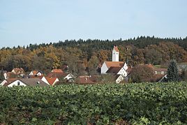
Place view
|
|
Kreuzholzhausen is a district and a parish village of the Bergkirchen community in the Upper Bavarian district of Dachau .
On May 1, 1978, the previously independent communities of Eisolzried , Feldgeding , Lauterbach and Oberbachern were dissolved and merged with parts of the dissolved communities of Günding and Kreuzholzhausen to form the new community of Bergkirchen.
Kreuzholzhausen is on the DAH10 district road.
Architectural monuments
It is possible that there was a church in Kreuzholzhausen over 1240 years ago. With a deed of donation dated April 28, 770, the church of St. Michael in Holzhusir (Holzhausen) was given to the diocese of Freising . Unfortunately, one does not know whether it is Kreuzholzhausen or Westerholzhausen.
In any case, the parish of Kreuzholzhausen was mentioned for the first time in 1315 in the Konradin register under the name "Holtzhausen". The church mentioned in this register is said to have been built in 1288.
Shortly after the Thirty Years' War, in which the town of Kreuzholzhausen and its church suffered badly, the church received its present-day appearance. At that time, in 1662/65, the church was rebuilt and extended (250 seats). During these renovations, the Gothic saddle tower was also raised. There are three bells in it today. The oldest was cast in 1665; So it still dates from the time of the major renovation. In 1723 the pilgrimage had created such a large financial basis that a new church roof could be put on and the church redecorated in the baroque style.
The main buildings are:
- Catholic parish and pilgrimage church Heilig Kreuz
- Rectory
See also: List of architectural monuments in Kreuzholzhausen
topography
From a topographical point of view, the highest point in the Dachau district is 557 m above sea level. NHN in Biberecker Holz not far from Kreuzholzhausen.
Web links
- Kreuzholzhausen in the location database of the Bavarian State Library Online . Bavarian State Library
- Bergkirchen community
Individual evidence
- ^ Federal Statistical Office (ed.): Historical municipality directory for the Federal Republic of Germany. Name, border and key number changes in municipalities, counties and administrative districts from May 27, 1970 to December 31, 1982 . W. Kohlhammer, Stuttgart / Mainz 1983, ISBN 3-17-003263-1 , p. 571 .
- ↑ http://kirchenundkapellen.de/kirchenko/kreuzholzhausen.php


