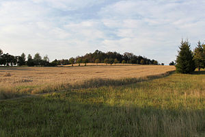
Krohnenberg
| Krohnenberg | ||
|---|---|---|
|
View from Hauswalde |
||
| height | 385 m above sea level NHN | |
| location | Großröhrsdorf , Saxony | |
| Coordinates | 51 ° 10 '0 " N , 14 ° 5' 43" E | |
|
|
||
| Type | Knoll | |
The Krohnenberg is a 385 meter high elevation in the north of the Großröhrsdorf district of Hauswalde in the Saxon district of Bautzen .
nature and environment
Together with the neighboring Kesselberg , the Krohnenberg forms the natural spatial unit of the Krohnenberg-Kesselberg-Ridge . This ridge marks the southern border of the north-west Lusatian mountainous region, which in turn is part of the western Lusatian hill and mountainous region.
The Hauswald stream rises at the southern foothills of the Krohnenberg .
Former mining
While plowing his arable land on the Krohnenberg in autumn 1903, a local farmer named Mager and his draft animals broke into a hole in the ground that suddenly opened up. After he and the animals were rescued, the investigation into the collapse of the earth discovered a historic ladder and a six-meter-long wooden gutter. The burglary was cleared to a depth of twelve meters, and two former, collapsed mine tunnels came to light. What exactly was mined in the tunnels on the Krohnenberg and until when the mining was carried out is not known for certain. In the grove on the hilltop, remains of heaps can be seen to this day , which mainly contain two-mica granodiorite and rock containing quartz . The remains of Schachtpingen can also be found.
Others
The name Krohnenberg is probably based on the historical name as Kranichberg . The name changed from Kranich to Krahnen to Krohnenberg. Kro (h) nenberg was also formerly an independent district of the Hauswalde community.
literature
- Lausitzer Bergland around Pulsnitz and Bischofswerda (= values of our homeland . Volume 40). 1st edition. Akademie Verlag, Berlin 1983.
Web links
Individual evidence
- ^ Westlausitzer Hügel- und Bergland (WHB). In: Technical contribution to the landscape program for nature and land use. Saxon State Office for Environment, Agriculture and Geology, accessed on December 11, 2018 (pdf file, 154 KB).
- ^ Rene Teich: Historical mining in the area of Bischofswerda, Rammenau and Hauswalde. In: Mining in the Hohwald and its surroundings. Retrieved October 23, 2015 .
- ^ Friedrich Bernhard Störzner: Former mining in the area around Bischofswerda and Neustadt . In: What the Heimat tells. Legends, historical images and memorable events from Saxony. Contributions to Saxon folklore and local history . Verlag Arwed Strauch, Leipzig 1904, p. 458–462 ( What the homeland tells on Wikisource ).
- ^ Meyers Orts- und Verkehrs-Lexikon des Deutschen Reichs . S. 743 ( Google Books ).
- ^ Raymond S. Wright: The Upper Lusatia, as a special division of Saxony's church gallery . Hermann Schmidt, Dresden 1861, p. 409 ( Google Books ).

