Kunzenbach (Tieflachgraben)
| Kunzenbach | ||
|
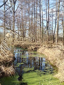
Lower reaches of the Kunzenbach |
||
| Data | ||
| Water code | DE : 2374866 | |
| location |
Northern Upper Rhine Valley
|
|
| River system | Rhine | |
| Drain over | Deep ditch → Federbach → Alb → Rhine → North Sea | |
| Branch | from the Federbach west of Durmersheim 48 ° 56 ′ 39 ″ N , 8 ° 16 ′ 15 ″ E |
|
| Source height | 107 m above sea level NHN | |
| muzzle | in the Tieflachgraben northwest of Durmersheim Coordinates: 48 ° 56 '44 " N , 8 ° 15' 27" E 48 ° 56 '44 " N , 8 ° 15' 27" E |
|
| Mouth height | 107 m above sea level NHN | |
| Height difference | 0 m | |
| Bottom slope | 0 ‰ | |
| length | 1.3 km | |
The Kunzenbach is a body of water around 1.3 kilometers long in the municipality of Durmersheim in the Baden-Württemberg district of Rastatt .
geography
The Rastatt Rhine Lowlands are criss-crossed by numerous silted up meanders of the Rhine . A meander near Durmersheim later took up the Federbach . Around 1800 the Federbach was laid in a 600-meter-long cut. The Kunzenbach runs in the upper and southern part of this loop of river, which is about 2.5 kilometers long; the lower and northern part is traversed by the Tieflachgraben, into which the Kunzenbach flows from the right.
The Kunzenbach branches off from the Federbach not far from the western outskirts of Durmersheim to the left and west. In the upper reaches it flows through an area with allotment gardens and sports fields. On the lower reaches of the left bank, the former impact slope of the river bend , there is an industrial area belonging to Durmersheim. Just before its confluence with the Tieflachgraben, a ditch flows from the left and south to the Kunzenbach, which comes from the Durmersheim district of Würmersheim and is lined with reeds and a wood with willows.
The Kunzenbach lies in the nature reserve Rheinniederung between Au am Rhein, Durmersheim and Rheinstetten or forms its border. In the lower reaches of the Gleithang a covered fen with a peat thickness of up to 70 centimeters borders the watercourse. Large parts of the moor are covered with reeds or willow bushes. Large areas are relatively often covered with water, so that conditions that are comparatively close to nature have arisen. In the upper reaches of the Kunzenbach is accompanied by woods and reeds.
Web links
- Map of the Kunzenbach to: State Institute for the Environment Baden-Württemberg (LUBW) ( information )
Individual evidence
LUBW
Official online waterway map with a suitable section and the layers used here: Map of the Kunzenbach
General introduction without default settings and layers: State Institute for the Environment Baden-Württemberg (LUBW) ( notes )
- ↑ a b Height according to the contour line image on the topographic map background layer or the digital terrain model of the online map.
- ↑ Length according to the waterway network layer ( AWGN ) .
- ↑ Open -land biotope mapping, survey form, widened ditch west of Würmersheim (No. 170152162843). (Accessed January 12, 2020)
- ↑ Protected areas according to the relevant layers.
- ^ Moore and Anmoore in the Upper Rhine Plain - 60th Federbach lowland sw. Mörsch. (Accessed January 12, 2020)
- ↑ Open- land biotope mapping, survey form field trees and reeds at the riding facility on Kunzbach (No. 170152162324). (Accessed January 12, 2020)
Other evidence
- ↑ Heinz Fischer: Geographical Land Survey: The natural spatial units on sheet 169 Rastatt. Federal Institute for Regional Studies, Bad Godesberg 1967. → Online map (PDF; 4.4 MB)
- ↑ Heinz Fischer: Geographical Land Survey: The natural spatial units on sheet 169 Rastatt. Federal Institute for Regional Studies, Bad Godesberg 1967. → Online map (PDF; 4.4 MB), p. 26.
-
↑ Old Federbachlauf see topographical plan of the Durmersheimer Bann belonging to the Oberamt Rastatt. (1785) at the General State Archives Karlsruhe ;
For the new Federbachlauf see Untitled (recording of the area between Au am Rhein, Steinmauern, Elchesheim, Bietigheim and Durmersheim with Bickesheim, 1825–1827) at the Generallandesarchiv Karlsruhe.
