
Löhr's garden

For about 100 years, Löhr's garden was a privately owned, publicly accessible park north-west of Leipzig's old town. A Leipzig city guide from 1860 comments:
- " A visit to the tastefully designed Löhrschen garden with its richly furnished greenhouses is just as instructive as it is pleasant ... "
Location and shape
Löhr's garden with an area of six hectares stretched from Löhrschen Platz (today Tröndlinring ) in an irregular, widening shape to the north as far as the Parthe . This corresponds to a current limit in the west by Pfaffendorfer Straße, in the north by the Parthe and in the east by Nordstraße with a slimming south from the center to the width of the Hotel Fürstenhof .
From the Löhrschen house, after a roundabout, an avenue led to the Parthe. The part of the garden to the west of it was geometrically structured and there was a large greenhouse in the middle . The eastern, larger part was laid out in the style of an English landscape garden and contained a large pond with a circular island crowned by a snail-shaped hill. The garden was decorated with statues.
The Löhrsche Haus at the southern end of the garden was a three-wing complex that opened onto the garden and was splendidly baroque on this side , with a relatively simple street front in plait style .
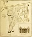
Plan of Löhr's garden

The pond with the island

The greenhouse

Löhr's house from the garden

The street side of the house


history
In 1764, after the death of his father-in-law Gottlieb Barthel , the Leipzig banker Eberhard Heinrich Löhr (1725–1798) came into the possession of Barthel's court . This apparently also included a plot of land north of the city, which up until this point was referred to as Barthel's garden in city plans . Löhr bought neighboring land and had his garden built in 1770/71 according to plans by Johann Carl Friedrich Dauthe (1749–1816) in the swampy terrain.
Dauthe also took over the construction of the residential palace at the south end of the garden in 1777/78. After the park and palace in Wörlitz , the English part of the garden and the street front of the house are among the earliest classicist creations in Central Germany and mark the beginning of the departure from the baroque in Leipzig.
In the Battle of Nations in 1813, the garden was badly devastated. However, its new owner Johann Georg Keil (1781–1857), the husband of Eberhard Heinrich Löhr's granddaughter, brought the garden back to its former glory. The garden was now also called Keils Garten .
The last owner of the property, Adolph Keil, had the property gradually parceled out from 1870 and sold the remaining part and the house in 1886 to the Leipzig real estate company, which had the site completely built on. Löhr's house was converted into the Hotel Fürstenhof in 1889 .
The former garden owners are still reminiscent of Löhrstrasse and Keilstrasse in the garden area at that time, as well as the Löhrs Carré high-rise complex with the headquarters of Sparkasse Leipzig and Sachsen Bank .
literature
- Nadja Horsch, Simone Tübbecke (Ed.): Citizens. Gardens. Promenades - Leipzig garden culture in the 18th and 19th centuries. Passage Verlag, Leipzig 2018, ISBN 978-3-95415-072-4 , pp. 106–111.
- Horst Riedel: Stadtlexikon Leipzig from A to Z. Pro Leipzig, Leipzig 2005, ISBN 3-936508-03-8 , p. 366
- Marianne Lutter: "Combining the pleasant with the useful", Löhr's garden - a former landscape garden in Germany . In: Nadja Horsch, Simone Tübbecke (ed.): Citizens' gardens promenades. Leipzig garden culture in the 18th and 19th centuries. Passage-Verlag Leipzig 2018, ISBN 978-3-95415-072-4 , pp. 106–111.
Web links
Individual evidence
- ↑ Gottfried Wilhelm Becker: Painting of Leipzig and its surroundings: for foreigners and locals, with special consideration for the battles in this city etc. , Hinrichs'sche Buchhandlg., 1823, p. 158
- ^ Carl Weidinger: Leipzig. A guide through the city. Leipzig 1860, reprint VEB Tourist Verlag Berlin / Leipzig, 1989, ISBN 3-350-00310-9 , p. 120
- ↑ www.neue-ufer.de
- ↑ For example in the plan from 1749 (position 34)
Coordinates: 51 ° 20 ′ 45 ″ N , 12 ° 22 ′ 24 ″ E