Lüderitz Bay
| Lüderitz Bay Angra Pequena |
||
|---|---|---|
|
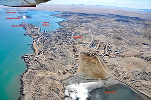
Aerial view of Shark Bay with Shark Island on the right and the mainland on the left |
||
| Waters | South Atlantic | |
| Land mass | southern africa | |
| Geographical location | 26 ° 38 ′ S , 15 ° 9 ′ E | |
|
|
||
| width | approx. 12 km | |
| depth | approx. 5 km | |
| Islands | Flamingo Island, Seal Island , Penguin Island , Shark Island | |
The Lüderitz Bay , called by the Portuguese explorer Bartolomeu Dias Angra Pequena ([ ˈaŋgɾa peˈkena ], Portuguese Small Bay ), is a bay in the South Atlantic near the seaport city of Lüderitz in Namibia .
description
The Lüderitz Bay is open to the North and Northwest to the Atlantic and is bordered by the Lüderitz Peninsula to the Southwest and West . The outermost headlands of the peninsula are the Angra Point and the Diaz Point .
The so-called Haifischbucht (as part of the Lüderitzbucht) lies between the African mainland and the offshore shark island and thereby forms a natural harbor basin (Robert harbor). Other islands in Lüderitz Bay are the seal and penguin islands and the small flamingo island . The first two islands mentioned are counted among the penguin islands , which, starting from Lüderitz Bay, extend 220 km to the north and 140 km to the south along the Namibian coast.
Like the Great Bay to the south of the Lüderitz Peninsula, the Lüderitz Bay forms a rugged coastal formation.
Formerly - and still today (as of 2019) for the Allgemeine Zeitung - Lüderitzbucht was synonymous with the city of Lüderitz.
Surname
Lüderitz Bay was named after the Bremen merchants Adolf Lüderitz , who acquired the area around the bay in 1883 and named it Lüderitzland , and his younger brother August Lüderitz , who caused the corvettes lying in the bay to hoist the German flag on August 7, 1884. Heinrich Vogelsang was on site for Lüderitz to prepare the purchase of the bay.

literature
- Johannes Paul : Germans, Boers and English in South West Africa. Accompanying word to a map of nationalities of Europeans in South West Africa. In: Koloniale Rundschau . Issue 9/10, 1931.
Web links
Individual evidence
- ↑ Lüderitz Bay on a map from the time of German South West Africa
- ↑ August Blind: Moderne Handels- u. Traffic geography with special consideration of the trade routes and means of transport of the present: a guide to supplement geographic textbooks and for self-teaching. L. Huberti, 1901, p. 65.
- ↑ Hand-rolled cigars from Lüderitz Bay. Allgemeine Zeitung, March 12, 2019.

