Lützendorf (Weimar)
|
Lützendorf
City of Weimar
Coordinates: 51 ° 0 ′ 0 ″ N , 11 ° 18 ′ 6 ″ E
|
||
|---|---|---|
| Height : | 270-330 m above sea level NN | |
| Postal code : | 99427 | |
| Area code : | 03643 | |
|
Location of Lützendorf in Thuringia |
||
|
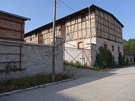
Manor in Lützendorf
|
||
Lützendorf is a residential area in the north of the city of Weimar in Thuringia .
location
The village, which has been handed down as a desert village, is located northwest of the city center on the outskirts and on the southern slope of the Ettersberg . The northern district is also known as Lutzen village and from national roads 85 / 7 affected.
history
Lützendorf was first mentioned in a document on March 3, 1295. In the civil war between 1448 and 1451, the place was completely destroyed except for a chapel , which was only demolished in 1530. During the Nazi era , the Lützendorf barracks were built in the area . After the end of World War II , the barracks were used by the US Army for a few weeks and by the Soviet Army for many more years . Since 1990 some of the barracks buildings have been renovated and put to civil use. Since then, Lützendorf has developed as part of the Weimar Nordstadt. There are shops, banks and savings banks, hotels and condominiums. The Kammergut Lützendorf used to be used for supplies and then stood empty for a long time. Now a client has been found.
Web links
Individual evidence
- ^ Wolfgang Kahl: First mention of Thuringian towns and villages. A manual. Rockstuhl Verlag, Bad Langensalza, 2010, ISBN 978-3-86777-202-0 , p. 172
- ↑ Kammergutes Lützendorf on the website of the University of Weimar.Retrieved on August 4, 2012


