L'Estartit
| Municipality of Torroella de Montgrí: L'Estartit | ||
|---|---|---|
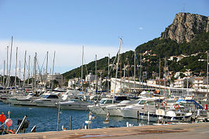
 Port of l'Estartit, behind the Roca Maura (226 m) of the Montgrí massif
|
||
| coat of arms | Map of Spain | |
 Help on coat of arms |
|
|
| Basic data | ||
| Autonomous Community : |
|
|
| Province : | Girona | |
| Comarca : | Baix Empordà | |
| Coordinates | 42 ° 3 ' N , 3 ° 12' E | |
| Residents : | 3,230 (2011) INE | |
| Postal code : | 17258 | |
| Area code: | 17199000300 | |
L'Estartit is a holiday resort and former fishing village on the Costa Brava in Spain, where tourism has only developed since the 1960s. It is a suburb of Torroella de Montgrí with 3,230 inhabitants (2011).
L'Estartit is located at the transition from a rocky cliff to a ten kilometer long, fine sandy beach in the lowlands of the river Ter , which flows into the Mediterranean after 208 km south of the village. The place, which was characterized as a fishing village until the 19th century, has developed into a highly frequented holiday destination with its own marina since the 1970s .
Upstream are the island group of the Illes Medes , a nature reserve known primarily to divers with an underwater flora and fauna incomparable in the Mediterranean . North of the place begins the massif Massís del Montgrí , which near the place has the elevations Roca Maura (226 m) and Torre Moratxa (218 m). Further on in the direction of Torroella de Montgrí is the Castell Montgrí , built at the end of the 13th century, on the Montgrí mountain .
About 500 m north of l'Estartit at ( 42 ° 3 ′ 37 ″ N , 3 ° 12 ′ 16 ″ E ) was a LORAN-C transmitter with a 190.5 meter high transmission mast.
Illes Medes in the backlight


