Ter
| Ter | ||
|
The Ter at Sant Quirze de Besora |
||
| Data | ||
| location | Spain | |
| River system | Ter | |
| source | Ull de Ter 42 ° 25 ′ 40 " N , 2 ° 15 ′ 24" E |
|
| Source height | 2480 msnm | |
| muzzle | into the Mediterranean Sea south of Torroella de Montgrí Coordinates: 42 ° 1 '25 " N , 3 ° 11' 40" E 42 ° 1 '25 " N , 3 ° 11' 40" E |
|
| Mouth height | 0 msnm | |
| Height difference | 2480 m | |
| Bottom slope | 12 ‰ | |
| length | 208 km | |
| Catchment area | 3010 km² | |
| Reservoirs flowed through | Pantà de Sau, de Susqueda, del Pasteral, de Colomers, de Seva | |
| Medium-sized cities | Girona | |
The Ter [ teɾ ] is a Catalan river in the comarca of Ripollès , Catalonia ( Spain ).
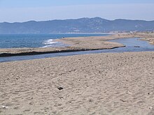
It rises in Ull de Ter at an altitude of 2480 msnm at the foot of a glacier, near the settlement of Setcases . After 208 km it flows into the Mediterranean between the towns of L'Estartit and Pals south of Torroella de Montgrí .
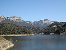
Between the comarcas Osona and Selva there is the Sau-Susqueda-Pasteral dam system , which is used to regulate the amount of water and generate electricity.
Tributaries
- Ritort
- Freser
- Riera de Vallfogona
- Ges
- Riera dels Sorreig
- Gurri
- Riera de les Gorgues
- Riera Major
- Riera de Rupit
- Brugent
- Riera d'Osor
- Riera de Llémena
- Onyar
- Terri
- Daró
Dams
Total capacity 407 hm³
- Pantà de Sau (height 84 m, surface 570 ha, capacity 169 hm³)
- Pantà de Susqueda (height 135 m, surface 466 ha, capacity 233 hm³)
- Pantà del Pasteral (height 33 m, surface 35 ha, capacity 2 hm³)
- Pantà de Colomers (height 15 m, surface 70 ha, capacity 1 hm³)
- Pantà de Seva (riu Gurri) (height 15 m, surface 2 ha, capacity <1 hm³)
Settlements
Web links
Commons : Ter - collection of images, videos and audio files


