
Montgrí massif

The Montgrí massif , in Catalan Massís del Montgrí ('Mountain Massif of the Gray Mountain'), is a karst mountain massif of around 300 meters in Catalonia in Spain , which is located directly on the Mediterranean Sea on the Costa Brava .
location

The Montgrí massif lies between the Ter plain and the Gulf of Roses and between the Alto and Baix Empordà areas . On the edge of the massif are the places Bellcaire d'Empordà, L'Escala , Ullà, Sobrestany, La Bolleria, Torroella de Montgrí and L'Estartit . Castell Montgrí from the end of the 13th century is located on the 301 meter high Montgrí mountain .
geology
The limestone massif was created from Mesozoic sedimentary rock . It appeared around 100 million years ago in the Tertiary . Due to the formation of the karst area , caves, crevices and sinkholes have formed as funnel-shaped depressions. According to archaeological finds, some of the around 50 known caves were already used by groups of hunters in the early Paleolithic around 300,000 years ago .
description

The area has an area of around 40 km² with an extension of about 8 × 5 kilometers. The highest peaks of the massif are Ullà (308 meters), Montgrí (303 meters), Montplà (311 meters), Roca Maura (225 meters) and Torre Moratxa (220 meters). The massif continues in the coastal archipelago of Illes Medes . The higher mountains of the massif are on its southwest side. The area is shallow to the north. Here it is more like a plateau with heights of around 140 meters compared to the surrounding area at around 30 meters above sea level.
The massif falls to the Mediterranean Sea through cliffs 50 to 100 meters to sea level. On the steep coast are calas , small bays that allow access to the water, such as Cala Pedrosa, Cala Ferriola, Cala Calella, Cala la Montgo.
The area has a total area of 37 km² protected by the Catalan Nature Conservation Plan (PEIN). South of the massif, sand dunes up to 50 meters high formed as a result of the Tramontana . In the 19th century they were localized by forest cover.
In the southern area of the Gulf of Roses , on the steep coast of the massif south of L'Escala at Punta Milà, remains of a former coastal defense line can be found. General Franco had this built after the Spanish Civil War in order to be able to militarily counter a possible invasion by the Allies on the extensive sandy beaches in the Bay of Roses.

Muntanya d'Ullà as part of the Massís
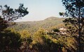
Wooded ridges in the mountain range

Cliffs to the Mediterranean

Cala Ferriola

Forest fire in 2004


Chapels
At Torroella de Montgrí on the ascent to the Montgrí mountain, there are two small chapels near a stone cross. They were probably erected as consecrated places of worship for Saint Santa Catarina . In the middle of the mountain range lies the Santa Catarina valley, in which there is a pilgrimage chapel of the same name. It was founded at the end of the 14th century by monks who came from the Montserrat monastery . A hermit lived in the chapel until the end of the 20th century . Every year on the Sunday before November 25th, the name day of the saints, a festival takes place there. According to a local legend , the newborn babies come out of the chapel's fountain.
Attractions


- Castell del Montgrí on the Montgrí mountain
- Wooded dunes near Les Dunes between Torroella de Montgrí and L'Estartit
- Sanctuary of Santa Caterina in the valley of the same name
- Caves, especially the Cau del Duc ( eagle owl cave) on the Montgrí
- Remains of a military coastal defense system from the 1930s south of L'Escala
- Cliffs with Calas
plants
Typical Mediterranean vegetation prevails. The massif is heavily deforested on the mountain tops with their stony areas by rocks and cliffs. In the lower areas there are extensive pine forests, but also scrub and heathland . The Aleppo pine is predominant among the trees . Flourished on the slopes of the mountain range in the 18th century, the wine , which in the 19th century with the advent of the phylloxera came into crisis. The terraces of the former cultivation areas can still be seen under the forest. The vegetation was damaged by devastating forest fires in the 1950s and most recently in 2004 .
Animals
In the animal world, there is a large presence of birds of prey such as Bonelli and toed Eagle , hiking - and Kestrel , Montagu's harrier and sparrow hawks . In the rocky terrain, blue roar and stone sparrow are characteristic. Birds of the forest are titmice , wood pigeons , crossbills .
Web links
- Landscape description
- Massís del Montgrí: photos, hiking tours, 2004 forest fire, Castell Montgrí, caves, St. Caterina chapel (Catalan)
- Log and photos of the forest fire of September 26, 2004 (Catalan)
Coordinates: 42 ° 4 ′ N , 3 ° 10 ′ E
swell
- ↑ CapCreus online The fortress works in Catalonia ( Memento of the original from November 19, 2010 in the Internet Archive ) Info: The archive link was inserted automatically and has not yet been checked. Please check the original and archive link according to the instructions and then remove this notice.