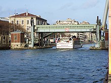
Quartier de la Villette
| La Villette (Paris) | |
|---|---|
| administration | |
| country | France |
| region | Île-de-France |
| city | Paris |
| Arrondissement | 19th arrondissement |
| Demographics | |
| Residents | 53,650 (1999) |
| Population density | 41,719 inhabitants / km² |
| geography | |
| Coordinates | 48 ° 53 '10 N 2 ° 22' 35 E |
| surface | 128.6 ha |
| Transport links | |
| Metro |
|
La Villette is the 73rd of 80 quarters (districts) of Paris . It is located in the northeastern part of the city and belongs to the 19th arrondissement .
Here are:
- the Bassin de la Villette with
- former commercial buildings that are now used as student apartments
- the last lifting bridge in Paris, the Pont levant de la rue de Crimée
- a cinema complex ( MK2 ), MK2 Quai de Loire / Quai de Seine
- the Rotonde de la Villette , a customs house designed by the architect Claude-Nicolas Ledoux in 1788, and the Place de la Bataille-de-Stalingrad
geography
The quartier de La villette forms the western part of the 19th arrondissement in the borders
- North-East: Quartier du Pont-de-Flandre ( Rue de l'Ourcq )
- South-east: Quartier du Combat ( Rue de Meaux and Avenue Jean-Jaurès )
- South-west: 10th arrondissement ( Quartier de l'Hôpital-Saint-Louis )
- North-West: 18th arrondissement ( Rue d'Aubervilliers )
history

The La Villette district emerged from the former municipality of La Villette, which was incorporated into Paris in 1860. The village was on the Paris – Flanders axis via Senlis , which is why the district's main thoroughfare is still called avenue de Flandre today . It used to consist of two localities ( La Grande Villette and La Petite Villette ) with a predominantly working-class population , numerous factories, the cattle market and the slaughterhouses of Paris. The slaughterhouse and cattle market were relocated to Pantin in 1974 and in 1979 a project was developed to convert the 55 hectare area, which almost extends to the Boulevard Périphérique , in order to revitalize this neglected and run-down district in the 19th arrondissement. This resulted in the Parc de la Villette with the technology museum Cité des sciences et de l'industrie . However, this part of the former village of La Villette now belongs to the Quartier du Pont-de-Flandre , which is located further northeast and also belongs to the 19th arrondissement.
Attractions
- Rotonde de la Villette on Place de Stalingrad
- Warehouses, on the Quai de la Seine and Quai de la Loire
- Residential tower, 1 Rue Duvergier
- former warehouses of department stores on Rue de Crimée
- Jewish cemetery , 44 avenue de Flandre
- Porte des Flamands, 69 rue de Flandre
- Logements "les Orgues de Flandre ", 67-107 rue de Flandre / 14/24 rue Archereau
- Église Saint-Jacques-Saint-Christophe , place de Bitche
- Gymnase et bains-douches municipaux, avenue Jean-Jaures
- Conservatoire municipal de musique Jacques-Ibert, 79-83 rue Armand-Carrel
- Synagogue , rue Jean-Nohain
Web links
- www.villette.com official website of the Parc de la Villette (French)
Coordinates: 48 ° 53 ′ 10 " N , 2 ° 22 ′ 35" E


