
Metro line 2 (Paris)
|
|
|||||||||||||||||||||||||||||||||||||||||||||||||||||||||||||||||||||||||||||||||||||||||||||||||||||||||||||||||||||||||||||||||||||||||||||||||||||||||||||||||||||||||||||
|---|---|---|---|---|---|---|---|---|---|---|---|---|---|---|---|---|---|---|---|---|---|---|---|---|---|---|---|---|---|---|---|---|---|---|---|---|---|---|---|---|---|---|---|---|---|---|---|---|---|---|---|---|---|---|---|---|---|---|---|---|---|---|---|---|---|---|---|---|---|---|---|---|---|---|---|---|---|---|---|---|---|---|---|---|---|---|---|---|---|---|---|---|---|---|---|---|---|---|---|---|---|---|---|---|---|---|---|---|---|---|---|---|---|---|---|---|---|---|---|---|---|---|---|---|---|---|---|---|---|---|---|---|---|---|---|---|---|---|---|---|---|---|---|---|---|---|---|---|---|---|---|---|---|---|---|---|---|---|---|---|---|---|---|---|---|---|---|---|---|---|---|---|---|
 map
| |||||||||||||||||||||||||||||||||||||||||||||||||||||||||||||||||||||||||||||||||||||||||||||||||||||||||||||||||||||||||||||||||||||||||||||||||||||||||||||||||||||||||||||
| Route length: | 12.4 km | ||||||||||||||||||||||||||||||||||||||||||||||||||||||||||||||||||||||||||||||||||||||||||||||||||||||||||||||||||||||||||||||||||||||||||||||||||||||||||||||||||||||||||||
| Gauge : | 1435 mm ( standard gauge ) | ||||||||||||||||||||||||||||||||||||||||||||||||||||||||||||||||||||||||||||||||||||||||||||||||||||||||||||||||||||||||||||||||||||||||||||||||||||||||||||||||||||||||||||
| Opening: | December 13, 1900 | ||||||||||||||||||||||||||||||||||||||||||||||||||||||||||||||||||||||||||||||||||||||||||||||||||||||||||||||||||||||||||||||||||||||||||||||||||||||||||||||||||||||||||||
| Passengers (daily) : | 253,000 | ||||||||||||||||||||||||||||||||||||||||||||||||||||||||||||||||||||||||||||||||||||||||||||||||||||||||||||||||||||||||||||||||||||||||||||||||||||||||||||||||||||||||||||
| Stations: | 25th | ||||||||||||||||||||||||||||||||||||||||||||||||||||||||||||||||||||||||||||||||||||||||||||||||||||||||||||||||||||||||||||||||||||||||||||||||||||||||||||||||||||||||||||
|
|||||||||||||||||||||||||||||||||||||||||||||||||||||||||||||||||||||||||||||||||||||||||||||||||||||||||||||||||||||||||||||||||||||||||||||||||||||||||||||||||||||||||||||
The line 2 of the Paris Métro connects the stations Porte Dauphine in Paris West and Nation in the east of the city. It largely uses the northern part of a ring-shaped route, the southern part of which is used by line 6 .
history
Changing names

According to the first drafts for the Paris subway network, the individual lines should be designated with letters, line 2 would have been given the designation B. The line, which was to become a ring line (with the appendage Étoile - Porte Dauphine), was finally given the number 2 as the second line in the network. After this ring had already been divided into a southern and a northern arch during the preliminary planning for the construction the two parts are designated 2 South and 2 North.
On October 14, 1907, the northern section received its final name: Line 2 North was renamed Line 2. Line 2 Sud was merged with line 5 three days later , which became the longest line in the Metro network between Étoile and Lancry (since 1946: Jacques Bonsergent ). Line 6 has been operating on the former line 2 south since 1942.
The construction of the route
.jpg)
The original plans provided for Line 1 to run to Porte Dauphine , but in the end the Porte Maillot station was chosen as the end point for it. The 1.6 km long Étoile - Porte Dauphine section was built at the same time as Line 1 and opened on December 13, 1900. The terminus at Porte Dauphine was given separate arrival and departure stations, each with two tracks on central platforms , which are connected by an end loop with a radius of only 30 meters. It has largely been preserved in its original state.
The route was initially used by shuttle trains, which consisted of three two-axle vehicles, a railcar and two sidecars . While these trains were able to turn around in the Porte Dauphine final loop, the railcar had to bypass the sidecar in a coupling terminal in the provisional Étoile terminus .


On October 7, 1902, the first extension from Étoile to Anvers station went into operation, followed by the next to Bagnolet (since 1970: Alexandre Dumas ) on January 31, 1903. On this section there is a 2.2 kilometer long viaduct with four Stations. This was built elevated train to a crossing under the in cuts contained railway tracks at two railway stations , the Gare du Nord and the Gare de l'Est and the Canal Saint-Martin to avoid. Since the provisional terminus had no turning loops, the trains received a railcar ( sandwich ) at both ends . As a result of this type of traction , the metro accident occurred on August 10, 1903 at Couronnes station in the tunnel section to the east of the viaduct line.
The construction was supervised by Fulgence Bienvenüe , the chief engineer at the Compagnie du chemin de fer métropolitain de Paris (CMP). As with the construction of Line 1, the tunnels were designed elliptically with a height of 5.20 meters. The stations were either designed as vaults or covered with metal plates. An important difference to the construction of Line 1 was that the tunnels of Line 2 were no longer built using shield driving , as this was not fully satisfactory. The tunnels were built in the traditional way with wooden supports ( paving slab with a vaulted ceiling).

The construction of the viaduct heated emotions in Paris. Some believed that a viaduct would spoil the cityscape. Others argued against the viaduct that it was twice as expensive as a tunnel. Ultimately, the supporters prevailed, and the viaduct route was quite popular with passengers. The idea of the viaduct came from Louis Biette, an engineer and employee of Bienvenües.
The Gare du Nord is crossed on two viaducts with a span of 75.25 meters each. Since the extension of the platforms for the Eurostar trains, they end directly under the Boulevard de la Chapelle , across the middle of which the elevated railway runs. The tracks in front of the Gare de l'Est are crossed on another 75.25 meter long viaduct . Some of the curves of the viaduct only have a radius of 75 meters, the ramp between the stations Jaurès and Colonel Fabien has a gradient of 40 ‰.
On April 2, 1903, the last section from Bagnolet to Nation went into operation. In the meantime, the stations that had not been completed on time in 1902 were also put into operation.
The tracks under the Place de la Nation are laid out in the form of a large circle. There are track connections to lines 1 and 9 as well as to the Atelier de Charonne depot, which opened in 1900 . The central platform for arrival and departure (tracks 1 and 3) of the terminus of line 2 is within the double-track turning loop through which passengers pass. The southern side platform, which was directly connected to the northern platform on Line 1 via passageways, is no longer used, and the operating track that was once on it no longer exists. Tracks 4, C and D outside the station are used to park trains.
Changes to the route in the interwar period

In 1931 the Victor Hugo station was relocated to improve boarding conditions. The original station was in a tight curve, resulting in distances of up to 50 cm between the platform and the car. For the sake of passenger safety, a new station was built in the straight section immediately east of the curve. The old platforms still exist, they are passed through without stopping.
Disruption of the line in World War II
When France declared war on Germany on September 3, 1939, Line 2, along with other lines, was completely closed. The reason was the conscription of many Métro employees to the military, but in this case also the fear of the bombing of the elevated railway viaduct. The line was not reopened until July 6, 1940.
Stations whose names have changed
- Boulevard Barbès became Barbès - Rochechouart on October 15, 1907
- Rue d'Allemagne became Jaurès in August 1914
- Aubervilliers became Aubervilliers - Boulevard de la Villette on October 6, 1942, and then Stalingrad on February 10, 1946
- Combat became Colonel Fabien on August 19, 1945
- Bagnolet became Alexandre Dumas on September 13, 1970
- Étoile became Charles de Gaulle - Étoile in February 1970
Technical innovations
A central PCC route control center for line 2 was set up in May 1973.
Line 2 vehicles and their maintenance
Vehicles and their use

At the beginning, the trains on the first section Porte Dauphin - Étoile were exceptional. Because of the initially low volume of traffic, only three-part trains were on the road. They consisted of a railcar with driver's cabs on both sides and two non-motorized sidecars. At the coupling end point Étoile, the railcar was transferred to the other end of the train.
As the route was extended, trains of up to eight parts were gradually used, each with a railcar with a driver's cab at each end of the train. This meant that it was no longer necessary to move the railcars at the provisional terminals at Anvers and Bagnolet before the Nation terminal loop could be used from April 1903 . Due to the use of the two end loops, the trains on Line 2 have practically always run in the same direction since then.


As a result of the accident at the Couronnes station, the CMP first coupled the two railcars to each other at the beginning of the train in order to avoid running the 600-volt cable for the traction current along the entire train. From 1904 vehicles of the type Thomson double were used. Instead of single axles, the railcars were given bogies with two engines each. Their car bodies were still made of wood, but for safety reasons the driver's cab was made of sheet metal. In 1906 there were the first railcars of the Sprague multiple design with multiple controls and metal car bodies on the line . Between 1914 and 1979 only vehicles of the Sprague-Thomson series , whose sidecars were longer than the previous ones, were used as five-car trains. The last of these trains ran on line 2 until 1981.
The first MF 67 vehicles were used from 1979, and for two years they ran on the line together with their predecessors. They came from other lines where they had been replaced by the MF 77 series. The first cars of this series were withdrawn in 2006.
In 2006 a vehicle from the pre-series of the MF 01 series was used, and the first series trains came on line 2 from 2008 onwards. In the meantime, they have completely replaced the previous series there.
Depots
From the loop under the Place da la Nation, a tunnel branches off the main route, in which two tracks lead to the Atelier de Charonne depot . From this branch line an operating track leads east to Line 1. The depot is reached via an above-ground, level crossing with Rue Lagny. This barrier-protected level crossing is unique on the Metro. It was also used for line 1 until the opening of the Fontenay depot . 1981–1983 it was reconstructed and now occupies an area of 10,900 square meters.

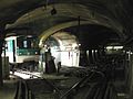
Departure station of the terminus Porte Dauphine

Villiers station

Entry of an MF 67 into the Stalingrad station

La Chapelle elevated railway station , 1994
Stored trains on tracks D and C east of the Nation station , in the middle the inner track towards Porte Dauphine


literature
- Jean Tricoire: Un siècle de métro en 14 lignes: De Bienvenüe à Météor . 3. Edition. La Vie du Rail, Paris 2004. ISBN 2-915034-32-X .
Web links
Individual evidence
- ^ Jean Tricoire: Un siècle de métro en 14 lignes. De Bienvenüe à Météor . 2nd Edition. La Vie du Rail, Paris 2000, ISBN 2-902808-87-9 , p. 197 f .
- ↑ Jean Tricoire, Un siècle de métro en 14 lignes (2nd ed.), P. 128.
- ↑ Jean Tricoire, Un siècle de métro en 14 lignes (2nd edition), p. 146 f.
- ^ Clive Lamming: Métro insolite . 2nd Edition. Editions Parigramme, Paris 2009, ISBN 978-2-84096-190-1 , pp. 82 .
- ↑ Jean Tricoire, Un siècle de métro en 14 lignes (2nd edition), p. 147 ff.
- ↑ Jean Tricoire, Un siècle de métro en 14 lignes (2nd ed.), P. 151.
- ↑ Jean Tricoire, Un siècle de métro en 14 lignes (2nd edition), pp. 210 and 258.
- ↑ Jean Tricoire, Un siècle de métro en 14 lignes (2nd ed.), P. 155.
- ^ Christoph Groneck: Metros in France . 1st edition. Robert Schwandl Verlag, Berlin 2006, ISBN 3-936573-13-1 , p. 14 .
- ↑ Le métro parisien sous l'occupation at archivchemindefer.free.fr, accessed on August 20, 2017
- ↑ Mark Ovenden: Paris Underground . Penguin Books, London 2009, ISBN 978-0-14-311639-4 , pp. 77 .
- ^ Brian Hardy: Paris Metro Handbook . 3. Edition. Capital Transport, Harrow Weald 1999, ISBN 1-85414-212-7 , pp. 101 .
- ↑ Jean Tricoire, Un siècle de métro en 14 lignes (2nd ed.), P. 161.
- ↑ Jean Tricoire, Un siècle de métro en 14 lignes (2nd ed.), P. 86.
- ↑ a b Jean Tricoire, Un siècle de métro en 14 lignes (2nd ed.), P. 151.
- ↑ Jean Tricoire, Un siècle de métro en 14 lignes (3rd ed.), P. 151 f.
- ↑ Les rames MF01 at symbioz.net, accessed on October 29, 2014
- ↑ Jean Tricoire, Un siècle de métro en 14 lignes (2nd ed.), P. 153.
Métro : • Grand Paris Express : •
RER : •
![]()
![]()
![]()
![]()
![]()
![]()
![]()
![]()
![]()
![]()
![]()
![]()
![]()
![]()
![]()
![]()
![]()
![]()
![]()
![]()
![]()
![]()
![]()
![]()
![]()
![]()
![]()
Transilien : •
Tram Express Nord • Tram Express Ouest • Tram Express Sud •
![]()
![]()
![]()
![]()
![]()
![]()
![]()
![]()
![]()
Tram : •
Bus •
Noctilien •
Funiculaire de Montmartre • OrlyVal • CDGVAL • LISA •
CDG Express![]()
![]()
![]()
![]()
![]()
![]()
![]()
![]()
![]()
![]()
![]()
![]()
![]()
![]()