Metro line 1 (Paris)
|
|
|||||||||||||||||||||||||||||||||||||||||||||||||||||||||||||||||||||||||||||||||||||||||||||||||||||||||||||||||||||||||||||||||||||||||||||||||||||||||||||||||||||||||||||||||||||||||||||
|---|---|---|---|---|---|---|---|---|---|---|---|---|---|---|---|---|---|---|---|---|---|---|---|---|---|---|---|---|---|---|---|---|---|---|---|---|---|---|---|---|---|---|---|---|---|---|---|---|---|---|---|---|---|---|---|---|---|---|---|---|---|---|---|---|---|---|---|---|---|---|---|---|---|---|---|---|---|---|---|---|---|---|---|---|---|---|---|---|---|---|---|---|---|---|---|---|---|---|---|---|---|---|---|---|---|---|---|---|---|---|---|---|---|---|---|---|---|---|---|---|---|---|---|---|---|---|---|---|---|---|---|---|---|---|---|---|---|---|---|---|---|---|---|---|---|---|---|---|---|---|---|---|---|---|---|---|---|---|---|---|---|---|---|---|---|---|---|---|---|---|---|---|---|---|---|---|---|---|---|---|---|---|---|---|---|---|---|---|---|
|
map
| |||||||||||||||||||||||||||||||||||||||||||||||||||||||||||||||||||||||||||||||||||||||||||||||||||||||||||||||||||||||||||||||||||||||||||||||||||||||||||||||||||||||||||||||||||||||||||||
| Route length: | 16.5 km | ||||||||||||||||||||||||||||||||||||||||||||||||||||||||||||||||||||||||||||||||||||||||||||||||||||||||||||||||||||||||||||||||||||||||||||||||||||||||||||||||||||||||||||||||||||||||||||
| Gauge : | 1435 mm ( standard gauge ) | ||||||||||||||||||||||||||||||||||||||||||||||||||||||||||||||||||||||||||||||||||||||||||||||||||||||||||||||||||||||||||||||||||||||||||||||||||||||||||||||||||||||||||||||||||||||||||||
| Opening: | 1900 | ||||||||||||||||||||||||||||||||||||||||||||||||||||||||||||||||||||||||||||||||||||||||||||||||||||||||||||||||||||||||||||||||||||||||||||||||||||||||||||||||||||||||||||||||||||||||||||
| Passengers (daily) : | 715,000 | ||||||||||||||||||||||||||||||||||||||||||||||||||||||||||||||||||||||||||||||||||||||||||||||||||||||||||||||||||||||||||||||||||||||||||||||||||||||||||||||||||||||||||||||||||||||||||||
| Stations: | 25th | ||||||||||||||||||||||||||||||||||||||||||||||||||||||||||||||||||||||||||||||||||||||||||||||||||||||||||||||||||||||||||||||||||||||||||||||||||||||||||||||||||||||||||||||||||||||||||||
|
|||||||||||||||||||||||||||||||||||||||||||||||||||||||||||||||||||||||||||||||||||||||||||||||||||||||||||||||||||||||||||||||||||||||||||||||||||||||||||||||||||||||||||||||||||||||||||||
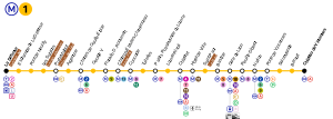
The Line 1 of the Paris Métro is the oldest and after the line 4 , the second most frequented on subway line in the city. On its way through Paris city center, it connects the stations La Défense in the west and Château de Vincennes in the east. Since December 2012 it has been served exclusively by driverless trains.
History and description
Line 1 was planned and built as Line A, it was only given its current name during the opening. The construction of the tunnels and platforms was carried out by the city of Paris, which wanted to use it and the branch lines B and C to make the world exhibition accessible. The exhibition took place between April 15 and November 12, 1900, mainly on the Champ de Mars and the Jardins du Trocadéro as well as the Esplanade des Invalides .
On March 30, 1898, the Déclaration d'utilité publique (Declaration of Public Benefit ) was announced, and construction began in the same year. The chief engineer of the bridge and road construction authority Fulgence Bienvenüe was appointed site manager. The future operator Compagnie du chemin de fer métropolitain de Paris (CMP) was responsible for building the workshops and power stations, laying the tracks, purchasing the vehicles and the track equipment .
The planned opening date in April 1900 could not be kept despite all efforts. At the end of May of that year, the eastern section of the line was completed. On June 7th, the first train - consisting of a multiple unit and a sidecar - came on the route from Porte de Vincennes to Bastille . The training trips for the staff began on June 15, and the laying of the tracks was completed on June 21. On that day a first test train reached the terminus at Porte Maillot . However, work on the signaling, the station equipment and the accesses was not yet completed. When the first metro line opened on July 19, 1900 after only 17 months of construction, only eight stations could therefore be put into operation.
From the first days of June, 16 three-car trains ran without passengers on the route. On June 11th, the route was approved by the responsible control authority without any objections. The first planned opening date, July 14, 1900, was abandoned because it was feared that there would be an excessive influx of passengers on the national holiday . The time of the opening was postponed first to July 16 and then again for three days.
The line from Porte Maillot to Porte de Vincennes finally opened on July 19, 1900 at 1 p.m. Lunchtime was chosen to avoid a possible rush of passengers. In any case, the world exhibition was the dominant theme. The opening of the Métro thus went largely unnoticed, and the population hardly seemed to be aware of the scope of this measure. But six three-car trains per hour and direction were no longer enough. After more vehicles were delivered, the cycle was reduced to six minutes on September 20. In the following weeks, the remaining ten stations, which were initially passed through without stopping, went into operation: Saint-Paul and Châtelet on August 6, Concorde and Alma on August 13, Reuilly and Louvre on August 20, Tuileries and Marbeuf on August 27, Étoile and Obligado on September 1, 1900.
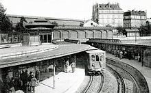
Line 1 crosses the city in an east-west direction. At both end stations there were separate platforms for departure and arrival, which were connected by tight turning loops with radii of 30 meters. This was necessary because the first trains consisted of only one railcar and two attached sidecars . At the western end of the Bastille station there is the narrowest curve in the entire metro network with a radius of only 38 meters. Of the total of eighteen stations, ten were designed as vaults, seven had a metal "cover", and the Bastille station is located in the open air above the Canal Saint-Martin .
In December 1900, with 130,000 users per day, the four millionth passenger was transported. It was decided to respond appropriately and the time was reduced from six to three minutes. The number of sidecars per train was gradually increased from three to six; they were now pulled or pushed by a railcar at each end of the train. The 7.44 to 8.88 meter long vehicles remained biaxial, but were given slightly wider double-wing sliding doors instead of single-wing . As a result of the accident at Couronnes station on line 2 on August 10, 1903, the vehicles were replaced in 1905 by four-axle cars, from 1908 of the Sprague-Thomson type .
Between January 18 and 26, 1910, after heavy rains, the level of the Seine rose from 2.65 meters to 8.62 meters. Near the station Quai de la Rapée came on January 24, water in the connecting tunnel to the line 5 and flooded the line 1 at a length of 2000 meters. Depending on the water level, it was only used in sections. Two days later, the Concorde underground station was flooded by the tunnel on line 8 , which was under construction, and the section under water reached 5100 meters. From February 24, 1910, traffic could be expanded again and the entire route could be used again on March 13 of that year.
An agreement from 1929 provided for the extension of the metro network to the suburbs. On March 24, 1934, the 2300 meter long eastern extension from Porte de Vincennes to today's terminal station Château de Vincennes went into operation. For this purpose, the former terminus Porte de Vincennes was rebuilt, and the Fontenay-sous-Bois depot was built at the new terminus.
The next extension was made on April 29, 1937, it led in the west from Porte Maillot to Pont de Neuilly . The old terminus was abandoned here and a new one went into operation on November 15, 1936. The Métro drives under the old turning loop, which was converted by the RATP in 1992 into a private screening room called "Espace Maillot". A Sprague Thomson car was brought there as an exhibit.
On April 1, 1992, the route was extended again: from Pont de Neuilly to La Défense (Grande Arche). The La Défense terminus of the Métro is a transfer station to line A of the Réseau Express Régional (RER) suburban train network , to suburban trains of the Transilien and to tram line T2 . To the west of the Pont de Neuilly station, the Métro comes to the surface, crosses the Seine in the middle of National Road 13 and then disappears underground again.
Vehicle use and technical innovations
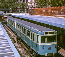
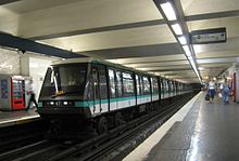
As the Métro line most used at the time, line 1 was the first to be converted for vehicles that run on nitrogen- filled rubber tires. This happened between May 30, 1963 and December 1964, during this period there was a mixed operation of Sprague-Thomson trains and new rolling stock of the MP 59 series . In 1967 the centralized operations management (PCC) and the partially automated pilotage automatique control were added. In 1997, the old vehicles of the MP 59 generation were replaced by those of the MP 89 type .
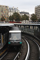
Between May 2011 and December 2012 the changeover to automatic, driverless operation with trains of the MP 05 series took place . For this reason, all stations were equipped with platform screen doors between 2009 and 2011 . The trains of the MP 89 series are now used on Line 4 .
Renaming of stations
During the more than 100-year history of the Paris Metro, the official names of a number of stations have changed. Some stations have even been renamed several times. The following stations are affected on Line 1:
| today's name | since | previous name (s) |
|---|---|---|
| George V | 1920 | Alma |
| Reuilly - Diderot | 1931 | Reuilly |
| Champs-Élysées - Clemenceau | 1931 | Champs-Élysées |
| Franklin D. Roosevelt | 1946 | until 1942: Marbeuf 1942–46: Marbeuf - Rond-Point des Champs-Élysées |
| Argentine | 1948 | Obligado |
| Charles de Gaulle - Étoile | 1970 | Étoile |
| Palais Royal - Musee du Louvre | 1989 | Palais Royal |
| Louvre - Rivoli | 1989 | Louvre |
| Saint-Mandé | 2002 | until 1937: Tourelle 1937–2002: Saint-Mandé - Tourelle |
Planned route extensions
In 2013, the Syndicat des transports d'Île-de-France (STIF) approved an extension of Line 1 to the east. The line will have three stations, the first station Les Rigollots will be on the city limits of Vincennes and Fontenay-sous-Bois . The new terminus will be Val de Fontenay at the RER station of the same name . The STIF initially suggested three different route options. After a public hearing, one variant was initially discarded, for the other two further investigations were carried out with regard to the connection of bus traffic, the expected volume of traffic, and feasibility. The decision was made in October 2016 in favor of the northern of the two remaining variants. The middle stop is now to be built near the city limits of Fontenay-sous-Bois and Montreuil .
An extension in the west from La Défense to Nanterre is under discussion, but it is quite possible that this route will ultimately be taken over by line 15 of the planned Grand Paris Express .
literature
- Jean Tricoire: Un siècle de métro en 14 lignes: De Bienvenüe à Météor . 3. Edition. La Vie du Rail, Paris 2004. ISBN 2-915034-32-X .
Web links
Individual evidence
- ↑ Communiqueé de Presse: Modérnisation du Métro. (PDF) STIF, February 8, 2012, accessed January 23, 2014 .
- ^ Jean Robert: Notre Métro . 2nd Edition. J. Robert, Neuilly-sur-Seine 1983, p. 31 ff .
- ^ Jean Tricoire: Un siècle de métro en 14 lignes. De Bienvenüe à Météor . 2nd Edition. La Vie du Rail, Paris 2000, ISBN 2-902808-87-9 , p. 131 u. 132 .
- ^ Christoph Groneck: Metros in France . 1st edition. Robert Schwandl, Berlin 2006, ISBN 3-936573-13-1 , p. 10 .
- ↑ a b Jean Tricoire, 2nd edition, p. 133.
- ↑ Jean Tricoire, 2nd edition, p. 84 f.
- ^ Jean Tricoire, 2nd edition, p. 21.
- ^ Jean Tricoire, 2nd edition, p. 134.
- ↑ Unmanned train journey, free of strikes at faz.net from October 4, 2014, accessed on October 29, 2014
- ↑ IDF: le tracé du prolongement de la ligne 1 du metro tranché. In: mobilicites.com. October 19, 2016, accessed October 20, 2016 (French).
