
Quai de la Rapée (Paris Metro)
|
|
|
|---|---|

|
|
| Tariff zone | 1 |
| Line (s) |
|
| place | Paris XII |
| opening | July 13, 1906 |


Quai de la Rapée is an above-ground station on line 5 of the Paris Métro .
location
The station is located between street Voie Mazas and Quai de la Rapée on the slopes of the northern shore of the Seine in the Quartier des Quinze-Vingts the 12th arrondissement of Paris .
Surname
The street Quai de la Rapée, which runs along the banks of the Seine, has been named after June 1, 1916. There was the former estate Râpée des Sieur de la Rapée, a war minister of Louis XV .
Initially, the station was called "Place Mazas" because it is located on the western edge of the square of the same name. Place Mazas is named after Jacques François Marc Mazas, a French general (1765–1805). On October 15, 1907, it was renamed "Pont d'Austerlitz". The nearby Pont d'Austerlitz road bridge over the Seine takes its name from the Battle of Austerlitz , during which Mazas was killed.
history
The station was put into operation on July 13, 1906 with the opening of the line coming from Gare d'Austerlitz and was temporarily the end point of line 5. From there a track leads to Gare de Lyon , which was used by shuttle trains for the first two weeks . For four and a half months, this single-track line was then used by the trains on line 5, which changed the direction of travel at the Place Mazas station. On December 17, 1906, line 5 was extended to Lancry station ( Jacques Bonsergent since 1946 ) and Place Mazas station became a through station. Direct traffic to Gare de Lyon was abandoned, this subway station was now accessible via the Bastille interchange .
During the flooding of the Seine , the station was completely flooded on January 21, 1910.
description
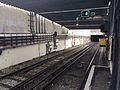
The station is 75 m long, the top of the rails is 35.71 m above sea level. Two full-length covered side platforms are located on two main tracks. It lies on a walled embankment along the Seine, at its northern end it turns into a curve. Immediately after the station, the Écluse de l'Arsenal lock of the Canal Saint-Martin is crossed on the Pont-métro Morland . The route then disappears under Boulevard Bourdon.
To the south, the route crosses a short tunnel under the access to the Pont d'Austerlitz. There the operating track branches off from the right track to Gare de Lyon and shortly afterwards crosses under the track. The route of line 5 then rises on the Viaduc du Quai de la Rapée with a gradient of 40 ‰ above street level and, after a sharp right-hand bend with a 90-degree angle and a radius of 75 m, reaches the Viaduc d'Austerlitz .
There is only one exit, it leads to Place Mazas. It is housed in a modern building.
vehicles
The Sprague-Thomson trains on line 5 were replaced from 1978 by vehicles from the MF 67 series , which were followed by MF 01 trains from 2011 .
Surroundings
- Bassin de l'Arsenal , a harbor basin built in the early 19th century in the moat of the former Bastille
Remarks
- ↑ The eponymous road bridge should not be confused with the Viaduc d'Austerlitz , which not far from it leads the Métro tracks across the Seine
- ↑ Mètres au-dessus du niveau de la mer (meters above sea level) corresponds to normal height zero −50 cm

Pont-métro Morland bridge over the Écluse de l'Arsenal lock at the north head of the station

North mouth of the tunnel on Boulevard Bourdon

Access building
Southern mouth of the tunnel under the approach to Pont d'Austerlitz


Web links
literature
- Gérard Roland: Stations de métro. D'Abbesses à Wagram . 2003, ISBN 2-86253-307-6 .
Individual evidence
- ↑ Le Paris pittoresque: Quai de la Rapée (French), accessed on March 12, 2014.
- ^ Jean Tricoire: Un siècle de métro en 14 lignes. De Bienvenüe à Météor . 2nd Edition. La Vie du Rail, Paris 2000, ISBN 2-902808-87-9 , p. 201 .
- ^ A b Gérard Roland: Stations de métro d'Abbesses à Wagram . Christine Bonneton, Clermont-Ferrand 2011, ISBN 978-2-86253-382-7 , pp. 179 .
- ↑ Jean Tricoire: op. Cit. P. 196 f.
- ^ Brian Hardy: Paris Metro Handbook . 3. Edition. Capital Transport Publishing, Harrow Weald 1999, ISBN 1-85414-212-7 , pp. 36 .
- ↑ a b Jean Tricoire: op. Cit. P. 196.
- ↑ Jean Tricoire, op. Cit. P. 198.
| Previous station | Paris metro | Next station |
|---|---|---|
|
Bastille ← Bobigny - Pablo Picasso |
|
Gare d'Austerlitz Place d'Italie → |
Coordinates: 48 ° 50 ′ 47.7 " N , 2 ° 21 ′ 57.2" E