
Seine floods in 1910
| Seine floods in 1910 | |
|---|---|
 |
|
 |
|
| storm | Flood |
| Data | |
| Emergence | January 18, 1910 |
| resolution | March 8, 1910 |
| Water level | 8.62 m (Pont d'Austerlitz in Paris, January 28, 1910 ) |
| Drain | 2400 m³ / s (Paris) |
| consequences | |
| Victim | 0 |
| Damage amount | 400 million gold francs |
The Seine flood in 1910 was - after the flood of 1658 - the second largest known flood on the Seine . It affected most of the Seine valley and, while not causing any fatalities, caused great economic damage, particularly in Paris . The Seine reached its highest level of 8.62 meters at the Pont d'Austerlitz gauge on January 28th. Many quarters of the capital and numerous cities had been flooded several weeks before and after. The rise of the flood lasted about 10 days, the runoff about 35 days.
The tributaries were affected to different degrees due to the independence of different hydrological systems.
During the great flood of 1910, the members of the Assemblée nationale met in boats to be able to resume their work. The Zouaves of the Pont de l'Alma , a sculpture on which the Parisians measure the level of the Seine, had the water up to their shoulders.
course

causes
The causes of the flood are a combination of several factors:
- high rainfall
- Snow and frost
- Crossing several bodies of water: Yonne , Loing , Grand Morin
- water-saturated soils throughout the Paris basin
chronology

- On January 20th, shipping on the Seine in Paris will be suspended because there is not enough space to pass under the bridges.
- On January 21st, the compressed air factory stops in XIII. Arrondissement the production, which brings the stop of elevators and public clocks.
- On January 23, the Seine reaches the height of the quay walls designed for floods of the height of 1876: part of Paris is flooded.
- On January 28, 1910, 22,000 cellars and hundreds of streets were flooded with water and ice and continued to be polluted with sewage. Tens of thousands of underground sewage pits were flooded that were not connected to the municipal sewer system. The tankers who have to evacuate those who remain outside Paris can no longer pass under the bridges. The sanitary situation becomes worrying, with cases of typhus and scarlet fever being reported.
- In the middle of March the flood subsided completely.
Damage
The flood caused direct damage amounting to 400 million gold francs (≙ more than 1.6 billion euros). In addition, there are 50 million gold francs for the auxiliary workers.
Bookstores and publishers suffered great losses and all their stocks were destroyed.
Ivry-sur-Seine

After the flood, the Pagès Camus vinegar factory exploded, followed by a devastating fire. Ivry-sur-Seine , partially completely destroyed, was by many personalities, such as B. Armand Fallières , Aristide Briand , Alexandre Millerand and Louis Lépine visited.
Paris
In Paris, 20,000 buildings were flooded. Half of the then existing metro network was flooded.
In the banlieue , the situation upstream and downstream was also dramatic with 30,000 flooded houses.
Gennevilliers
In Gennevilliers , the dikes were completely flooded and the leakage of sewage made the situation worse. The parish buildings were particularly affected. More than 1000 apartments were flooded, 150 evacuated and 13 even collapsed.
Villeneuve-la-Garenne
In Villeneuve-la-Garenne the flooding reached catastrophic proportions. Despite the dikes, the water was 1.20 m high in many places. Agricultural land was devastated, houses collapsed and many animals drowned. In parts of the community the houses could be entered through the windows on the first floor. From January 21st, the roads to Gennevilliers and Asnières were under water. On January 26th the schools were evacuated. In the night of January 27th to 28th, the dikes were flooded. The worst affected families were evacuated by boats or makeshift boats. It took a few days for the levels to fall again, but the clean-up work took several weeks.
L'Île-Saint-Denis, Saint-Denis and Épinay-sur-Seine
The floods also caused great damage in the western areas, where today the Seine-Saint-Denis ( L'Île-Saint-Denis , Saint-Denis , Épinay-sur-Seine ) is located.
Hisetal
Since six cleaning and waste incineration plants on the banks of the Seine were inaccessible, Prefect Louis Lépine launched Operation Ordures au fil de l'eau (“Garbage in the watercourse”) to avoid epidemics : 500 Hippomobile wagons collected 1,500 tons of waste every morning and tipped them from the Pont de Tolbiac and the Viaduc d'Auteuil into the Seine to ship them into the English Channel . Due to the receding water levels, the garbage soon began to accumulate on the quays and in the alluvial forests of the downstream communities, causing protests from them.
Photo gallery
In Paris
Rue Leblanc, in the 15th arrondissement
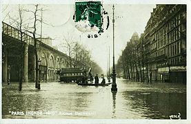
The avenue Daumesnil

The flood disrupted a large part of public transport, here the Gare Saint-Michel - Notre-Dame

_pendant_les_inondations_de_1910.jpeg)


In the Paris area

The railway line at Gare de Villeneuve-Saint-Georges , upstream from Paris
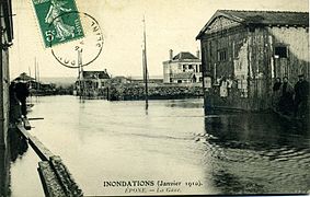
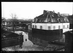
The Gare d ' Épône - Mézières

Flooding in Épinay-sur-Seine

Floods at Saint-Denis and Épinay-sur-Seine

Flood on the Vieux pont de Limay

"Le tramway passait dans cette rue d ' Asnières-sur-Seine " ("The tram passed through this street from Asnières-sur-Seine")

Military auxiliaries in Asnières-sur-Seine

The team of engineers helped with the relief efforts in L'Île-Saint-Denis


_-_ISD_-_Pontonniers_du_G%C3%A9nie.jpg)
High water marks

Paris, at the Pont Alexandre III

Paris, Rue de Bellechasse, Académie d'agriculture de France
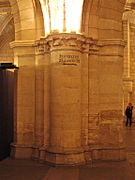
Paris, Conciergerie

Paris, Hôpital des Quinze-Vingts , high water mark from 1740 above

Paris, Port des Célestins

Paris, rue des Ursins

Val-de-Marne, at the Marne bridge Pont de Bry

High water marks at the Port de l'Arsenal


.jpg)


literature
- Jeffrey H. Jackson: Paris under water: how the city of light survived the great flood of 1910. Palgrave Macmillan, New York 2009, ISBN 978-0-230-61706-3 (English).
- Jean-Michel Lecat, Michel Toulet: Paris sous les eaux: de Choisy-le-Roi à Asnières. Chronique d'une inondation, janvier-février 1910. Ouest France, Rennes 2009, ISBN 978-2-7373-4824-2 (French).
- The flood in Paris : Schweizer Illustrierte , Volume 14.1910, pp. 102-103. ( E-periodica )
- Paris inondé: la grande crue de 1910. In: Journal des débats. Ed. du Mécène, Paris 2009, ISBN 978-2-907970-93-8 (French).
- Philippe Mellot: Paris inondé photographies janvier 1910. Ed. de Lodi, Paris 2003, ISBN 2-84690-037-X (French).
- The flood disaster in Paris in 1910. In: The world. January 24, 2014. ( welt.de ).
Videos
- Paris sous les eaux: une vidéo de l'inondation de 1910 on bigbrowser.blog.lemonde.fr (French)
- La crue de la Seine. on France 3 Paris Île-de-France (French)
- Jean-Christophe Victor , TV show with open cards , from June 4 and 11, 2016 ( arte ): Paris under water - danger known, danger misunderstood. ( YouTube ; Question whether such an event could repeat itself today and the possible consequences)
Web links
- Institute for Spatial and Urban Planning (Institut d'Aménagement et d'Urbanisme) of the greater Paris area: Baignade interdite. (French; Une application cartographique développée par l'IAU îdF. Information on areas at risk of flooding.)
- Revivez la crue exceptionnelle de 1910 à Paris jour par jour. on france3-regions.francetvinfo.fr (chronology, french)
- Paris sous l'eau: 3D simulation de la crue centennale. on france3-regions.francetvinfo.fr (background and simulation, French)
Individual evidence
- ↑ a b c d Goede: Crue de la Seine in Paris in 1910. In: Aquadoc France. April 30, 2004, accessed March 9, 2016 (French).
- ↑ January 18, 1910: Crue historique de la Seine. In: pluiesextremes.meteo.fr. Retrieved on March 9, 2016 (in French, the highest level of the Seine at the Pont de la Tournelle was 8.50 m on January 29, 1910; the absolute high was 1658 (8.81 m).).
- ↑ Michaela Wiegel: Flood scenario for Paris A flood would hit five million people. In: Frankfurter Allgemeine Zeitung. January 24, 2014, ISSN 0174-4909 , ( faz.net ).
- ^ Philippe Mellet: Paris au temps des fiacres . Borée, Romagnat 2006, ISBN 2-84494-432-9 , p. 101 (French).
- ↑ Ivry-sur-Seine (94) - Inondation 1910. In: inondation1910.free.fr. Retrieved March 10, 2016 (French).
- ↑ exhibition Paris inondé 1910 in the gallery of Bibliothèques., 2010