Saint-Paul (Paris Métro)
|
|
|
|---|---|

|
|
| Tariff zone | 1 |
| Line (s) |
|
| place | Paris IV |
| opening | August 6, 1900 |

Saint-Paul is an underground station on Line 1 of the Paris Métro . It is located in the historic Marais district on the southern edge of the Jewish quarter of Pletzl .
location
The metro station is located in the Saint-Gervais district of the 4th arrondissement of Paris . It lies lengthways under the Rue de Rivoli at the junction with the Rue Saint-Antoine .
Surname
It is named after the Rue Saint-Paul, which branches off from Rue Saint-Antoine. The missionary Paulus von Tarsus lived in the 1st century and is venerated as a saint in the Roman Catholic Church . The nearby Saint-Paul-Saint-Louis church also bears his name .
After the surrounding district, the station bears the suffix “Le Marais” (English: the swamp). It owes its name to the former marshland on the northern bank of the Seine , which was drained in the 13th century and used for growing vegetables.
history
The station was opened on August 6, 1900, after line 1 had already gone into operation on July 19, 1900. At that time, this operated on the section from Porte de Vincennes to Porte Maillot , although not all stations were served in the early days. Initially the station was 75 m long, at the beginning of the 1960s it was extended to 90 m and converted for traffic with rubber-tyred trains .
During the First World War , the station was damaged in a German bombing raid in April 1918. In April 2009 the platforms were raised and later equipped with platform screen doors as part of the introduction of driverless operation .
description
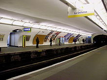
The station has side platforms on two main tracks, it is located under an elliptical vault with curved side walls. The extension from the 1960s lies under a round vault that rests on pillars near the platform edge. At the eastern end of the station there is a ventilation shaft that allows daylight to enter as a light shaft.
The only entry and exit is at the junction of Rue de Rivoli and Rue Saint-Antoine, also known as “Pointe Rivoli”. It is marked by a Val d'Osne candelabra. Another exit nearby is provided with an escalator.
vehicles
Initially, trains ran on Line 1, which consisted of a railcar with only one driver's cab and two sidecars . These vehicles were two-axle and each nearly nine meters long. As early as 1902, eight-car trains were formed, each with a railcar at the ends of the train. The railcars were replaced by four-axle vehicles on bogies until 1905, and the sidecars from 1906 . In 1908, green painted five-car trains of the Sprague-Thomson design entered Line 1, which stayed there until the 1960s. From May 1963, the Sprague-Thomson trains, which ran on rails, were successively replaced by the MP 59 series with rubber-tyred vehicles , until December 1964 there was mixed traffic of the two modes of operation. The MP 89 CC series followed in 1997, which gave way to the MP 05 series with the start of automatic operation .
Surroundings
- Marais district
- Pletzl Jewish quarter from the 18th century
- Place des Vosges
- Rue des Rosiers
- Lycée Charlemagne
Remarks
- ↑ The Marais is not a district according to the Paris administrative structure
- ^ After the metro accident at Couronnes station in August 1903, both railcars ran one behind the other at the Zugspitze
- ↑ From the early 1930s, the trains on line 1 were light gray with a red 1st class car
- ↑ CC means "Conduite Conducteur" (driver-controlled), in contrast to the driverless type MP 89 CA
Web links
literature
- Gérard Roland: Stations de métro. D'Abbesses à Wagram . 2003, ISBN 2-86253-307-6 .
Individual evidence
- ^ Gérard Roland: Stations de métro d'Abbesses à Wagram . Christine Bonneton, Clermont-Ferrand 2011, ISBN 978-2-86253-382-7 , pp. 80 .
- ↑ a b Gérard Roland, op. Cit. P. 196.
- ^ Jean Tricoire: Un siècle de métro en 14 lignes. De Bienvenüe à Météor . 2nd Edition. La Vie du Rail, Paris 2000, ISBN 2-902808-87-9 , p. 131 .
- ^ Brian Hardy: Paris Metro Handbook . 3. Edition. Capital Transport Publishing, Harrow Weald 1999, ISBN 1-85414-212-7 , pp. 36 .
- ↑ Jean Tricoire: op. Cit. P. 134.
- ↑ Jean Tricoire: op. Cit. P. 74.
- ↑ Jean Tricoire: op. Cit. P. 132 ff.
| Previous station | Paris metro | Next station |
|---|---|---|
|
Hôtel de Ville ← La Défense |
|
Bastille Château de Vincennes → |
Coordinates: 48 ° 51 '18.9 " N , 2 ° 21' 40.2" E


