
Rue Saint-Antoine
| Rue Saint-Antoine | |
|---|---|
| location | |
| Arrondissement | 4th |
| quarter | Arsenal Saint-Gervais |
| Beginning | 3, Place de la Bastille |
| The End | 2, rue de Sévigné 16, rue de Fourcy |
| morphology | |
| length | 603 m |
| width | 21.50 |
| history | |
| Original names | Grande Rue Rue de la Porte-Baudeer Rue de la Porte-Baudet Rue de l'Aigle Grant-rue-de-la-Porte-Baudeer Rue du Pont-Perrin |
| Coding | |
| Paris | 8769 |

The Rue Saint-Antoine in Paris is one of the oldest streets in the city. It already existed in Gallo-Roman times and was part of the road from Paris to Melun . The street is steeped in history due to its proximity to the Place de la Bastille . It is an important artery in the heart of the Marais and crosses typical streets such as Rue Saint-Paul , Rue de Turenne , Rue de Birague (which leads to Place des Vosges ) or Rue Beautreillis .
location
The Rue Saint-Antoine begins at the Place de la Bastille 3 crosses in the 4th arrondissement
- the Quartier de l'Arsenal (numbers 1 to 85 and 2 to 72)
- the Saint-Gervais district (nos. 87 to 137 and 74 to 100)
and ends after 603 meters at Rue de Sévigné 2, Rue de Rivoli 1 or Rue François Miron 1.
The street is an important part of the east-west axis of Paris . It starts at the Place de la Bastille and ends at the Saint-Paul metro station (line ), or it continues, under the name “ Rue de Rivoli ”, to the Place de la Concorde . This east-west axis continues from Place de la Bastille via Rue du Faubourg Saint-Antoine .
![]()
![]()
Name origin

"Rue Saint-Antoine"
The street owes its name to the Saint-Antoine-des-Champs abbey , where it led to.
history
Already in Gallo-Roman times there was a road from Paris to Melun on the north bank of the Seine . It was higher than the surrounding marshland ( Marais ) and was covered with slabs, which in turn served as a base for the later roads. This Roman road branched off north of the Seine from the ancient Cardo to the east (roughly where the Rue Saint-Martin - part of the old Cardo - begins), followed today's Avenue Victoria, then ran across the Place de l'Hôtel-de- Ville and also through the Hôtel de Ville , then left past the parish church of Saint-Gervais-Saint-Protais , and followed today's Rue François Miron and finally Rue Saint-Antoine to the Bastille and beyond.
In the Middle Ages, the Rue Saint-Antoine stretched on this Roman road from the Rue des Barres to the Place de la Bastille. The part that has been called Rue François Miron since 1865 was called Rue de l'Aigle and Grand'rue de la Porte Baudeer in 1227 (Baudoyer or Baudet - a city gate from the 11th century directly north of Saint-Gervais, today the Place is located here Building approval). The piece to the east of it, today's Rue Saint-Antoine, was then called Rue du Pont Perrin. The rue Saint-Antoine ended in the city at the Place de Grève, the transhipment point for river trade, but also offered a junction at the level of the Porte Baudoyer with the rue de la Tixeranderie (which no longer exists today), with which one can continue into the City came in without touching the market square.
It was named Rue Saint-Antoine because of the Abbey of Saint-Antoine-des-Champs , which was outside the city (i.e. beyond the Bastille) on the road to Vincennes Castle and was converted into a hospital in 1790.
Today's Rue Saint-Antoine was extraordinarily wide for its time, which is why it was also used as a promenade and as a venue for events - especially the Charles V residence , the Hôtel Saint-Paul (on the south side), and the Hôtel des Tournelles (on the north side) here, in the immediate vicinity of the Bastille, was the Bastide Saint-Antoine, which closed the road to the east.
The Rue Saint-Antoine was then also the scene of the tournament in which King Henry II was injured so badly on June 30, 1559 that he died a few days later.
Attractions
The no longer existing buildings of the Middle Ages:
- the old Porte Sainte-Antoine (from the wall of Philip Augustus , stood where the Rue de Rivoli begins)
- the Bastille and the Nouvelle Porte Saint-Antoine (from the wall of Étienne Marcels )
- the Hôtel Saint-Paul
- the Hôtel d'Orgemont or Hôtel des Tournelles (the area on both sides of the Rue de Birague up to the Place des Vosges)
- the Hôtel der Blanka of Navarre in the Rue de la Vieille-Tixeranderie, which gave way to the construction of a road in the 19th century
- the Couvent Sainte Cathérine (at today's Place du Marché Sainte-Cathérine), and
which together framed almost the entire area of the Rue Saint-Antoine.
Date from a later time
- Church of Sainte-Marie-des-Anges de la Visitation, now the Temple du Marais Protestant church (No. 17)
- Hotel de Mayenne (No. 21)
- Hôtel de Sully (No. 62)
- Church Saint-Paul-Saint-Louis (no. 99)
- Lycée Charlemagne (No. 101)
such as
- The Place des Vosges at the end of the Rue de Birague

Orientation board (Paris)
" Lycée Charlemagne "
Orientation table (Paris)
" St-Paul-St-Louis (Paris) "
Orientation board (Paris)

Rue Saint-Antoine.

St-Paul-St-Louis (Paris) View from the Rue de Sévigné .
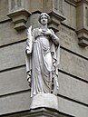
Catherine of Alexandria , corner of Rue de Sévigné .

Entrance to Passage Charlemagne .

Neidkopf , facade N. 133 before the renovation in 2014


literature
- Claude Dubois: La Rue Saint-Antoine. Éditions Jean-Paul Rocher, "L'air de Paris" collection, 2011, ISBN 978-2-917411-44-5 .
- Jacques Hillairet : Connaissance du vieux Paris. Éditions Princesse, Paris, 1978 ISBN 2-85961-019-7 , pp. 13-15.
- Jacques Hillairet: Dictionnaire historique des rues de Paris. Editions de Minuit.
- Jacques Hillairet: La Rue Saint-Antoine. Éditions de Minuit, 1970, ISBN 2-7073-0563-4 .
- Félix et Louis Lazare: Dictionnaire administratif et historique des rues de Paris et de ses monuments.
- Jean de La Tynna: Dictionnaire topographique, étymologique et historique des rues de Paris. 1817.
Web links
- Extrait de la nomenclature officielle des voies de Paris ( Memento of February 9, 2007 in the Internet Archive )
- Excerpt from the city map of Paris (Viamichelin)
Individual evidence
- ↑ Originally the street name Saint-Anthoine was written; the letter h has remained in English.