
Metro line 4 (Paris)
|
|
|||||||||||||||||||||||||||||||||||||||||||||||||||||||||||||||||||||||||||||||||||||||||||||||||||||||||||||||||||||||||||||||||||||||||||||||||||||||||||||||||||||||||||||||||||||
|---|---|---|---|---|---|---|---|---|---|---|---|---|---|---|---|---|---|---|---|---|---|---|---|---|---|---|---|---|---|---|---|---|---|---|---|---|---|---|---|---|---|---|---|---|---|---|---|---|---|---|---|---|---|---|---|---|---|---|---|---|---|---|---|---|---|---|---|---|---|---|---|---|---|---|---|---|---|---|---|---|---|---|---|---|---|---|---|---|---|---|---|---|---|---|---|---|---|---|---|---|---|---|---|---|---|---|---|---|---|---|---|---|---|---|---|---|---|---|---|---|---|---|---|---|---|---|---|---|---|---|---|---|---|---|---|---|---|---|---|---|---|---|---|---|---|---|---|---|---|---|---|---|---|---|---|---|---|---|---|---|---|---|---|---|---|---|---|---|---|---|---|---|---|---|---|---|---|---|---|---|---|
 map
| |||||||||||||||||||||||||||||||||||||||||||||||||||||||||||||||||||||||||||||||||||||||||||||||||||||||||||||||||||||||||||||||||||||||||||||||||||||||||||||||||||||||||||||||||||||
| Route length: | 12.1 km | ||||||||||||||||||||||||||||||||||||||||||||||||||||||||||||||||||||||||||||||||||||||||||||||||||||||||||||||||||||||||||||||||||||||||||||||||||||||||||||||||||||||||||||||||||||
| Gauge : | 1435 mm ( standard gauge ) | ||||||||||||||||||||||||||||||||||||||||||||||||||||||||||||||||||||||||||||||||||||||||||||||||||||||||||||||||||||||||||||||||||||||||||||||||||||||||||||||||||||||||||||||||||||
| Opening: | 1908 | ||||||||||||||||||||||||||||||||||||||||||||||||||||||||||||||||||||||||||||||||||||||||||||||||||||||||||||||||||||||||||||||||||||||||||||||||||||||||||||||||||||||||||||||||||||
| Passengers (daily) : | 740,000 | ||||||||||||||||||||||||||||||||||||||||||||||||||||||||||||||||||||||||||||||||||||||||||||||||||||||||||||||||||||||||||||||||||||||||||||||||||||||||||||||||||||||||||||||||||||
| Stations: | 27 | ||||||||||||||||||||||||||||||||||||||||||||||||||||||||||||||||||||||||||||||||||||||||||||||||||||||||||||||||||||||||||||||||||||||||||||||||||||||||||||||||||||||||||||||||||||
|
|||||||||||||||||||||||||||||||||||||||||||||||||||||||||||||||||||||||||||||||||||||||||||||||||||||||||||||||||||||||||||||||||||||||||||||||||||||||||||||||||||||||||||||||||||||
The line 4 of the Paris metro with about 740,000 daily passengers (2013) the most frequented the entire Paris metro -Netzes. It connects the stations of Porte de Clignancourt in the north of the city and Mairie de Montrouge in the southern suburb of Montrouge . This line has only left the Paris urban area since the extension in March 2013 . It offers transfer options to all metro (except 3 bis and 7 bis ) and RER lines.
Importance of the route
Line 4 has been of great importance in the Parisian transport system since it was commissioned: It was the first north-south connection after the previously built routes essentially ran in a west-east direction.
Today line 4 is the Parisian metro line with the second largest number of passengers. On its way through the city, it stops at three of the most important long-distance train stations. It also offers transfer options to all other metro lines (with the exception of short routes 3 to and 7 to ) and to all RER lines, as well as to tram line 3a .
history

Due to unexpected difficulties when crossing the Seine , Line 4 had to be opened in three sections.
The 1st construction phase
The 5-kilometer northern section from Porte de Clignancourt to Châtelet with a turning loop, siding and the Ateliers de Saint-Ouen depot in the area of the city of Saint-Ouen was put into operation on April 21, 1908.
The 2nd construction phase
The southern section from the then terminus Porte d'Orléans with a turning loop to Raspail with a length of 1.7 kilometers followed on October 30, 1909.
The 3rd construction phase with gap closure


There has been a continuous connection since January 9, 1910, when the 3.9-kilometer Châtelet - Raspail section was put into operation. The Saint-Michel and Cité stations were opened with a little delay in July and December 1910 respectively.
According to the original planning, the route should continue north of the Vavin station on Boulevard Raspail, then turn into Rue de Rennes and follow its planned extension to the Seine. Then the Seine should be crossed. North of the Seine, it should then go through the Rue de l'Amiral de Coligny , along the east facade of the Louvre, to connect to the northern section at the Châtelet station . But since the Boulevard de Raspail had not yet been widened, the planning was changed. The Métro was led through the Boulevard du Montparnasse to the Montparnasse train station , where a station was created, and from there to the Rue de Rennes. But the extension of the Rue de Rennes was also a long time coming. It was therefore proposed to build at a greater depth and to drive under several buildings, including the Institut de France . There they strictly refused to take this construction measure.
The redesign finally led the route through Boulevard Saint-Germain and Rue Danton to Boulevard Saint-Michel . This was followed by the most demanding construction section of around 1100 meters in length, namely the crossing under two arms of the Seine and the island of Île de la Cité in between, as well as the damp and unstable bank area on both sides of the Seine. The route then led north of the Seine to Châtelet station. During this planning, only one building, namely a barracks on the Ile de la Cité, had to be underpassed.
The contractor Léon Chagnaud received the building contract in 1905. He had already made a name for himself with the construction of the Opéra station when he built an underground structure in which lines 3, 7 and 8 crossed. His suggestion was to build a tube that should contain two tracks and which should be sunk into the ground in sections in prefabricated pieces using the caisson method.
The competing designs provided for the usual method of shield tunneling . The tunnel would then have had to be built at a much greater depth.
To cross the northern arm of the Seine, three tube sections, each around 40 meters long, were used. They are slightly curved and form a curve with a radius of 350 meters. For the southern arm, two straight, approximately 20-meter-long pieces of pipe were sufficient. However, these were not laid perpendicular to the direction of flow, but at an angle to it.

Due to a lack of space, the individual components could not be erected at the place of installation, but a few hundred meters downstream.
They consist of cast iron tubbings that are screwed together to form a watertight tub . They rest on a rectangular but bottomless base (the actual caisson). The side walls are stable and taper off at the bottom. The finished tubes were provisionally sealed at the ends so that they could be brought to the installation site in a floating manner. There they were fixed by two wooden moles - which also served as work scaffolding. First, a second tub layer was built concentric to the wall inside the tube, which was fixed to the outer wall by struts. The space between the two Küvelagen was then filled with concrete. Due to the increasing weight of the tubes, they sank to the ground, and the water was forced out of the space enclosed by the base by increased air pressure. Workers were now able to remove the earth in this pressure chamber so that the caisson including the pipe section could be lowered to the desired depth. After reaching the final position, the caisson cavity was filled with concrete.
The tubes were lowered one by one. They worked from north to south. The first tube section was sunk in late 1905 / early 1906, the last in spring and summer 1907.
The two metro stations in this area, namely Cité and Saint-Michel, were also sunk into the ground using the caisson method. The necessary Küvelagen were built directly at the place of installation on the earth's surface. They are considerably larger than the tubes for the river crossing, namely 12.5 meters high and 16.5 meters long. Each station measures 118 meters and consists of three caissons. The middle one is 66 meters long and contains the actual station. An elliptical shaft, which contains the stairs and an elevator, connects to each end. The caissons were brought into the ground separately from each other, with the floor slab already concreted.
The middle piece of pipe of the north arm is lowered

A pipe section of the southern arm is lowered

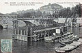
Part of the Saint-Michel station before the lowering begins

Cross-section through the stairwell of this route section


Another difficult point was the continuation of the crossing under the Seine between the southern bank of the Seine and the Saint-Michel station . The ground was soaked and not very compact, and a railway line (now part of the RER C network) runs parallel to the bank , which under no circumstances could be closed for a long period of time. It was decided to stabilize the ground by freezing the ground, which then happened in 1908 and 1909. With two chillers installed on site, brine, cooled to −25 ° C, was pumped through around 40 pipes that had been driven deep into the ground. After 40 days of pre-cooling, the ground was so frozen that the excavation work could begin.
The Seine floods in 1910
Just two weeks after the entire route went into operation, the Seine flooded unprecedentedly, paralyzing around half of the existing metro network: on January 24, 1910, the water level of the Seine began to rise. Water also penetrated into the tunnels of Line 4 and from January 27, rail operations had to be limited to the Porte de Clignancourt - Gare du Nord and Vavin - Porte d'Orléans sections . As the water levels fell, traffic could gradually be expanded again from mid-February, but the route was not completely passable again until April 6th.
Line 4 during World War II
A few months before the German Wehrmacht withdrew from occupied Paris, Line 4 was damaged: In preparation for the landing in Normandy , the German Wehrmacht's supply routes were to be severely disrupted. In this context, the Dépôt de La Chapelle locomotive depot and a freight yard in the north of Paris were bombed by American planes in April 1944. The adjacent Ateliers de Saint Ouen workshop on line 4 was also badly damaged. In addition, a stray bomb hit the ceiling of Simplon Station . Only after several days of clean-up and repair work was the route accessible again.
Later construction work on the route
Extension of the platforms
In order to be able to travel with the rubber-tyred six-unit trains, the platforms were lengthened to 90 meters in the mid-1960s.
Relocation of the Les Halles station
In the course of the construction of the Châtelet-Les Halles RER station , the route was changed slightly in this area and, in particular, the Les Halles station was moved to the east by around 80 meters in 1977 in order to shorten the transfer routes to the new RER station. To do this, the tunnel had to be laid over a length of 330 meters.
Extension of the Porte d'Orléans - Mairie de Montrouge route
On March 23, 2013, with the opening of the 1.5-kilometer route to Mairie de Montrouge, the first extension of metro line 4 beyond the Paris city limits went into operation.
The tunnel leads far beyond the terminus Mairie de Montrouge to almost the next planned station Verdun Süd : In the rear single-lane part of the extension there is a small system with a maintenance pit for minor repairs and maintenance work, the middle area is used to park unneeded trains and the The front part adjoining the platforms is used to change the direction of travel of the trains.
Renaming of stations
In the course of the more than one hundred year history of the Paris Metro, the official names of a number of stations have changed. Some stations have even been renamed several times. Four stations were affected on line 4:
| today's name | since | previous name (s) |
|---|---|---|
| Réaumur - Sébastopol | 1907 | Rue Saint-Denis |
| Saint-Placide | 1913 | Vaugirard |
| Strasbourg - Saint-Denis | 1931 | Boulevard Saint-Denis |
| Marcadet - Poissonniers | 1931 | Marcadet |
| Montparnasse - Bienvenüe | 1942 | Montparnasse |
Planned route extensions
In the south

In the south, the line is to be extended by another 1.9 kilometers via Mairie de Montrouge towards Bagneux . Two more stations, Barbara and Bagneux - Lucie Aubrac, are built . The last station in Bagneux will allow a transition to the planned route 15 of the Grand Paris Express . Construction work began in 2014 and completion is scheduled for 2021.
At the end of 2013, the Syndicat des transports d'Île-de-France (STIF for short) approved the use of around 180 million euros for the second section of the extension. The French state contributes 26% of the costs, the Île-de-France region with 60% and the Hauts-de-Seine department with 14%. A 2 km long tunnel, two train stations and a bus terminal at the terminus are to be built.
In the North
The expansion plan for the Metro network also includes an extension to the north-west: via Mairie de Saint-Ouen station with a connection to line 13 and the planned extension of line 14 is to extend the route to the new terminus at Saint-Ouen Les Docks in the immediate vicinity of the Seine become. However, there are still no concrete plans and financing for the project. A construction should only be considered after 2030.
Technical improvements
- In 1969 a central route control center (called PCC ) was put into operation.
- The semi-automatic control ( pilotage automatique ) has been used since 1971 .
- In October 1966 the first trains with rubber tires were on the route. The last trains with steel tires were withdrawn in 1967.
Traffic on Line 4 now and in the future
The current situation
Line 4 is the slowest of the entire Paris metro network: its trains only reach an average travel speed of 20.8 km / h. The fastest line is line 14, the cruising speed achieved there is almost 40 km / h. On line 4 the average distance between two stops is 465 meters, on line 14 it is 1,145 meters. 40 trains run simultaneously on line 4 during rush hour.
Planned automation
On July 10, 2013, the public transport authority STIF gave the RATP the go-ahead for the automation of line 4. This should greatly improve the speed of travel on the route. It is hoped that the transport capacity will increase by 20% because the trains will be able to run every 85 seconds. Analogous to Line 1 , the stations of the line will initially be equipped with platform screen doors. The work will be carried out by Siemens and should be completed by 2022. Passenger operations are scheduled to begin in 2020.
After the automation, the rolling stock from Line 14 will be used on Line 4. With the released rolling stock of Line 4, older trains will be replaced on other rubber-tyred lines. 32 trains will be taken over from line 14 (21 MP89 and 11 MP05). In addition, the STIF approved the purchase of 20 6-unit trains of the new MP14 series for use on this line. The first driverless trains are to be used from 2021, and the changeover is to be completed in 2022.
A somewhat problematic line
Line 4 has a bad reputation among Parisians as it is still the line with the highest temperatures: because of the vehicles on rubber tires, the friction of which generates a lot of heat, the chronic overcrowding of the cars and the fact that line 4 is a of the few completely underground lines, there is strong warming on the trains in summer.
It also has the highest crime rate of any Paris subway line.
literature
- Jean Tricoire: Un siècle de métro en 14 lignes: De Bienvenüe à Météor . 3. Edition. La Vie du Rail, Paris 2004. ISBN 2-915034-32-X .
Web links
- Track plan of line 4
- Publication of the STIF on the history of the crossing under the Seine (French)
Individual evidence
- ↑ a b LE STIF AUTORISE LE LANCEMENT DES ÉTUDES PRÉALABLES À L'AUTOMATISATION DE LA LIGNE 4. (PDF; 177 KiB) STIF, July 10, 2013, accessed on July 13, 2013 .
- ↑ Metroccupation (French) with photos
- ^ Page of the RATP on the extension to Montrouge ( memento of the original from March 26, 2013 in the Internet Archive ) Info: The archive link was automatically inserted and not yet checked. Please check the original and archive link according to the instructions and then remove this notice.
- ↑ RATP page on the planned extension to Bagneux
- ↑ Début des travaux du prolongement de la ligne 4 du métro (…) - Portail du STIF ( Memento of the original dated November 1, 2013 in the Internet Archive ) Info: The archive link was inserted automatically and has not yet been checked. Please check the original and archive link according to the instructions and then remove this notice.
- ↑ STIF press release from December 2013 (French) accessed on March 23, 2014
- ↑ Cinq faits à connaître sur le métro parisien Le Figaro of March 12, 2013; the data refer to the year 2011 (French) accessed on December 30, 2013.
- ↑ a b Siemens equips Line 4 of the Paris Metro for driverless operation. Siemens, January 7, 2016, accessed January 8, 2016 (press release PR2016010120MODE).
- ↑ RATP cleared to automate Paris metro Line July 4 , 2013, accessed on July 13, 2013 .
- ↑ Alstom va fournir 20 nouvelles rames MP14 au Stif. December 7, 2016, accessed December 7, 2016 .
- ↑ Observatoire national de la délinquance - Phénomènes de délinquance dans les transports en commun ferrés d'Île-de-France ( Memento des Originals of December 14, 2013 in the Internet Archive ) Info: The archive link was inserted automatically and has not yet been checked. Please check the original and archive link according to the instructions and then remove this notice. (PDF; 1.3 MB)
Métro : • Grand Paris Express : •
RER : •
![]()
![]()
![]()
![]()
![]()
![]()
![]()
![]()
![]()
![]()
![]()
![]()
![]()
![]()
![]()
![]()
![]()
![]()
![]()
![]()
![]()
![]()
![]()
![]()
![]()
![]()
![]()
Transilien : •
Tram Express Nord • Tram Express Ouest • Tram Express Sud •
![]()
![]()
![]()
![]()
![]()
![]()
![]()
![]()
![]()
Tram : •
Bus •
Noctilien •
Funiculaire de Montmartre • OrlyVal • CDGVAL • LISA •
CDG Express![]()
![]()
![]()
![]()
![]()
![]()
![]()
![]()
![]()
![]()
![]()
![]()
![]()
![]()