
Châtelet (Paris Métro)
|
|
|
|---|---|

|
|
| Tariff zone | 1 |
| Line (s) |
|
| place | Paris I , IV |
| opening | August 6, 1900 |
| Connected stations |
Châtelet-Les Halles → |

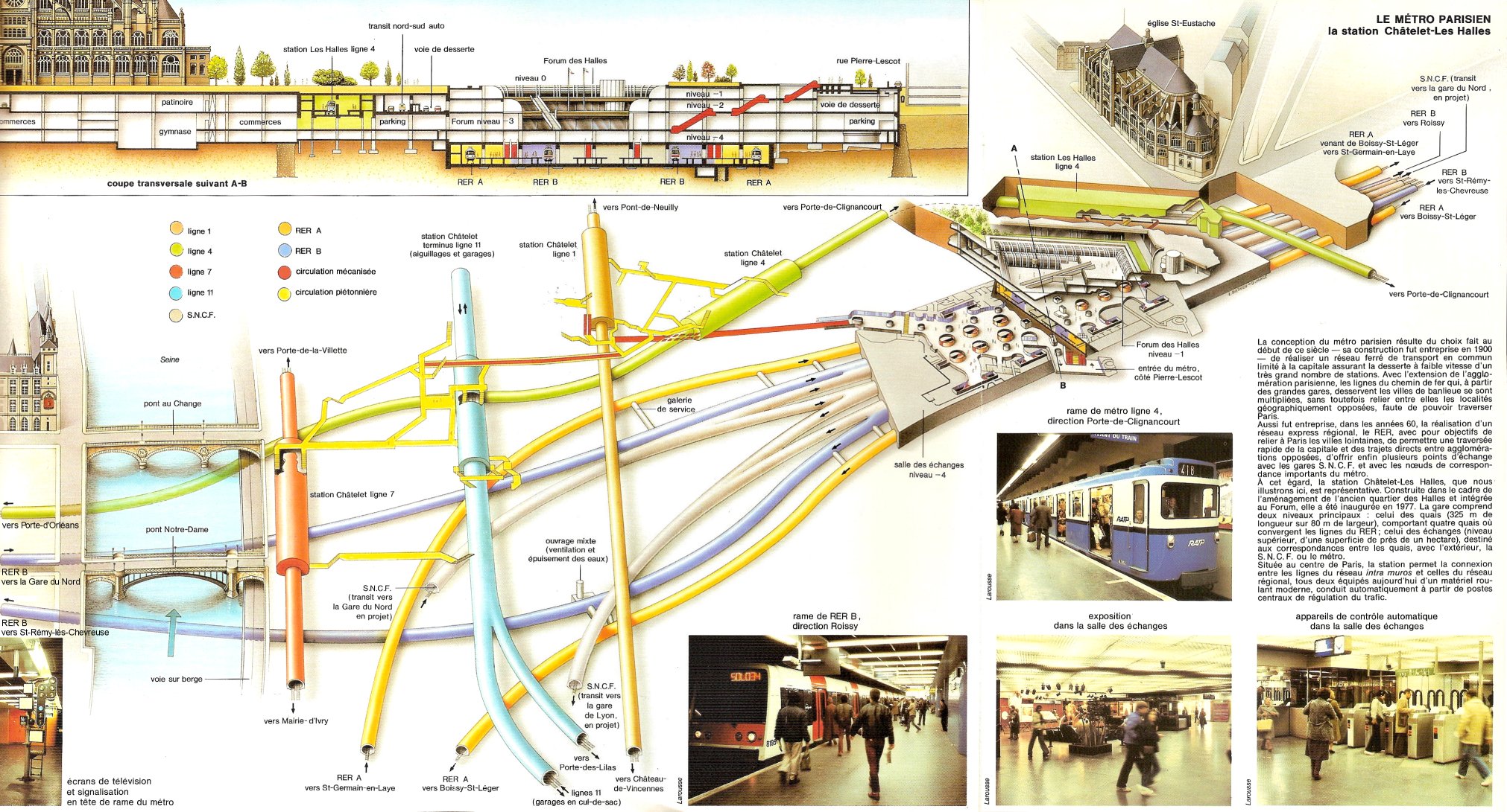
The Châtelet underground station is the central transfer station in the Paris Métro network . It is served by lines 1 , 4 , 7 , 11 and 14 , each with its own station. In addition, there is a connection to the Châtelet-Les Halles train station, which can be used to connect to the S-Bahn- like RER lines A , B and D. Around 39,000 visitors pass the underground station every day, and the ensemble of five stations is one of the ten most heavily frequented underground stations in the city.
location
The subway station is located on the border of the district St Germain l'Auxerrois and Quartier des Halles in the 1st arrondissement with the Quartier Saint-Merri in the 4th arrondissement of Paris .
The station of line 1 is located lengthways below the Rue de Rivoli immediately west of its intersection with the Rue Saint-Denis . Line 4 has its station under the Rue des Halles. Immediately on the banks of the Seine , southeast of the Pont au Change road bridge , the line 7 station is located alongside the Quai de Gesvres. The terminus of line 11 is north of it, along the Avenue Victoria in front of the Park Square de la Tour Saint-Jacques . The station of line 14 is located under one block, to the west parallel to the station of line 4.
Surname
It is named after the Place du Châtelet . The Grand Châtelet castle, built on the site in 1130, secured the Grand Pont bridge (today: Pont au Change), the river crossing from the northern bank of the Seine to the Île de la Cité . After the construction of the city wall, the building became the official residence of Prévôt de Paris in the 13th century and served a. a. as a court and prison. In 1802 it was demolished on the orders of Napoleon Bonaparte .
When it opened, the underground station was given the name "Pont au Change", which it kept until 1926. The bridge of the same name was built with houses until 1788, in which exchange offices (fr: Bureaux de change) resided. From 1926 to 1934 the underground station was called “Pont Notre-Dame”.
history
The line 1 station was opened on August 6, 1900. This had already been put into operation on July 19, 1900 and was then running on the section from Porte de Vincennes to Porte Maillot , although not all stations were served in the early days.
On April 21, 1908, the station of the same name on line 4 went into operation. At first it was the terminus of the trains coming from Porte de Clignancourt . The link with the southern section of line 4, which was opened in 1909, took place on January 9, 1910, when the crossing under the Seine was commissioned.
In the course of the eastern extension of line 7, its station followed on April 16, 1926, now under the name "Pont Notre-Dame". The construction work proved difficult because of the wet subsoil, the still existing foundations of the Grand Châtelet and a sewer.
Line 11 received its station on April 28, 1935, now under its current name. It still has its starting point there and initially led only 5500 m to Porte des Lilas .
The last expansion of the metro station was the opening of line 14 station (from Madeleine to Bibliothèque François Mitterrand ) on October 15, 1998.
description

The stations of lines 1 to 11 are located under elliptical , tiled ceiling vaults, the side walls follow their curvature. The station on line 14 has a round vaulted ceiling and vertical side walls. With the exception of line 11, there are side platforms on two parallel tracks.
The station on line 11 has a side platform as the terminus for the arriving trains. Upon arrival, they continue to a three-track system with two siding and a turning track in between. The departure platform is located as a central platform between two tracks, from which both the main track and another storage group can be reached - possibly via a double track connection.
The stations of lines 7 and 11 have the original standard length of 75 m, those of lines 1 and 4 were extended to 90 m in the 1960s. Lines 1 and 14 are used by automatic trains, whose stations are therefore equipped with platform screen doors.
There are no rail connections between the five metro lines at Châtelet underground station. To the west of the line 1 station there is a simple platform change . The stations of lines 1 and 7 are on the same level, those of line 11 are one level lower, which in turn is crossed by line 4. The station of Line 14, built using the shield tunneling method, is even lower .
All stations are connected to each other by corridors for those changing. On October 21, 1974 - the first in the Paris Métro - moving walks with a length of 132 m were installed. There are fourteen entrances from the street, the older ones were designed by Hector Guimard in the Art Nouveau style. One of the entrances is adorned with a replica of the former entrance roof at the Gare de Lyon station .

Line 1 station in front of the installation of the platform screen doors, 2008

Station of line 4

Station of line 7

Station of line 11, looking towards the parking and turning area

Station of line 14


vehicles
Initially, trains ran on Line 1, which consisted of a railcar with only one driver's cab and two sidecars . These vehicles were two-axle and each nearly nine meters long. As early as 1902, eight-car trains were formed, which were made up of six trailer cars and one railcar at each end of the train. The railcars were replaced by four-axle vehicles that rested on bogies until 1905 and the sidecars from 1906 . In 1908, green five-car Sprague-Thomson trains entered Line 1, and they stayed there until the 1960s. From May 1963, the Sprague-Thomson trains, which ran on rails, were successively replaced by the rubber-tyred vehicles of the MP 59 series, until December 1964, mixed traffic of the two modes of operation prevailed. The MP 89 series followed in 1997, which gave way to the MP 05 series with the start of automatic operation .
Until 1928, five-car trains consisting of initially three twin-engine and later two four-engine railcars and sidecars ran on Line 4. They were replaced by Sprague-Thomson trains, which were successively replaced by rubber-tired six-car trains of the MP 59 series in 1966/67. The MP 89 CC series is currently in use on Line 4 .
Conventional five-car trains of the MF 77 series run on Line 7. Between 1971 and 1979 trains of the MF 67 series ran there , before that of the Sprague-Thomson type.
Line 11 was initially also equipped with Sprague-Thomson trains. After the reconstruction of the line in 1956, they were initially replaced by the "rubber" MP 55 series . Four-car trains of the MP 59 and (since 2009) MP 73 series have been running since 1999 .
Surroundings

- Tour Saint-Jacques , a 51 m high Gothic bell tower of the former church Saint-Jacques-la-Boucherie
- Fontaine du Palmier , a victory column erected in 1808 on a plinth well from 1858
Remarks
- ↑ The stations on Line 1 were converted accordingly in 2011
- ^ After the metro accident at Couronnes station in August 1903, both railcars ran one behind the other at the Zugspitze
- ↑ Unlike usual, the trains on Line 1 have been painted light gray (with a red 1st class car) since the 1930s
- ↑ CC means "Conduite Conducteur" (driver-controlled), in contrast to the driverless type MP 89 CA
Web links
literature
- Gérard Roland: Stations de métro. D'Abbesses à Wagram . Bonneton, Paris 2003, ISBN 2-86253-307-6 .
Individual evidence
- ^ Jean Tricoire: Un siècle de métro en 14 lignes. De Bienvenüe à Météor . 2nd Edition. La Vie du Rail, Paris 2000, ISBN 2-902808-87-9 , p. 342 .
- ^ Gérard Roland: Stations de métro d'Abbesses à Wagram . Christine Bonneton, Clermont-Ferrand 2011, ISBN 978-2-86253-382-7 , pp. 80 .
- ↑ a b Gérard Roland: op. Cit. P. 81.
- ↑ Jean Tricoire: op. Cit. P. 131.
- ↑ Jean Tricoire: op. Cit. P. 224 f.
- ^ Brian Hardy: Paris Metro Handbook . 3. Edition. Capital Transport Publishing, Harrow Weald 1999, ISBN 1-85414-212-7 , pp. 36 .
- ↑ Jean Tricoire: op. Cit. P. 324 ff.
- ↑ Les édicules d'Hector Guimard at lartnouveau.com, accessed on August 20, 2017
- ↑ Jean Tricoire: op. Cit. P. 132 ff.
- ↑ Jean Tricoire: op. Cit. P. 183 f.
- ↑ Jean Tricoire: op. Cit. P. 227 and 245.
- ↑ Jean Tricoire, op. Cit. P. 284.
| Previous station | Paris metro | Next station |
|---|---|---|
|
Louvre - Rivoli ← La Défense |
|
Hôtel de Ville Château de Vincennes → |
|
Les Halles ← Porte de Clignancourt |
|
Cité Mairie de Montrouge → |
|
Pont Neuf ← La Courneuve - May 8, 1945 |
|
Pont Marie Mairie d'Ivry or Villejuif - Louis Aragon → |
| final destination |
|
Hôtel de Ville Mairie des Lilas → |
|
Pyramides ← Saint-Lazare |
|
Gare de Lyon Olympiades → |
Coordinates: 48 ° 51 '30.1 " N , 2 ° 20' 50.1" E