
19th arrondissement (Paris)
|
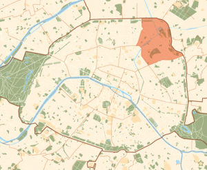
19th Arrondissement (Buttes-Chaumont) Arrondissement municipal of Paris |
|
|---|---|
  |
|
| Coordinates | 48 ° 52 '55 " N , 2 ° 22' 53" E |
| height | 60 m (41– 122 m ) |
| surface | 6.786 km² |
| Residents | 187,015 (Jan. 1, 2017) |
| Population density | 27,559 inhabitants / km² |
| INSEE code | 75119 |
| Post Code | 75019 |
| Website | mairie19.paris.fr |
| structure | |
| Quarters |
|
The 19th arrondissement of Paris , the Arrondissement des Buttes-Chaumont , is the northeasternmost of the 20 arrondissements of Paris . It was founded in 1860 and consists of the following locations: the former municipality of La Villette , parts of Aubervilliers and Pantin, and parts of the former municipality of Belleville .
Geographical location
The 19th arrondissement is Rive Droite . Its southeastern part lies on a hill ( Butte Chaumont ), which drops to the northwest to the Canal de l'Ourcq . In the north it borders on the municipality of Aubervilliers , in the east on Pantin and Le Pré-Saint-Gervais , in the south on the 20th and in the west on the 18th and 10th arrondissement .
Quarter in the 19th arrondissement
The arrondissement consists of the following four districts:
- Quartier de la Villette
- Quartier du Pont-de-Flandre
- Quartier d'Amérique
- Quartier du Combat
According to the official census of the Parisian districts, these are Quartiers 73 to 76.
town hall

The 19th arrondissement town hall is located at 5-7 Place Armand Carrel. The building was built in 1869 by the architect Gabriel Davioud .
mayor
The mayor has been François Dagnaud , a member of the Socialist Party ( PS ), who succeeded his fellow party member Roger Madec, who ruled from 1995 to 2013, in office since 2013 .
Infrastructure
See also: List of streets and squares in the 19th arrondissement (Paris)
The two main streets of the arrondissement are avenue de Flandre and avenue Jean-Jaurès , both of which extend to Place de la Bataille-de-Stalingrad .
The 19th arrondissement is crossed by the Canal Saint-Denis and Canal de l'Ourcq , which flow south of the Parc de la Villette into the Bassin de la Villette , which is connected to the Canal Saint-Martin (10th arrondissement).
Facilities
- Hôpital Robert-Debré hospital
- Archives de Paris
- Lycée Henri-Bergson
- the CENTQUATRE cultural center , formerly a municipal funeral home, 104 rue d'Aubervilliers
Green spaces
There are two large parks in the arrondissement: the modern Parc de la Villette , opened in 1986, and the picturesque Parc des Buttes-Chaumont , designed by Jean-Charles Alphand in 1867 .
Attractions

- The Bassin de la Villette , the largest artificial body of water in Paris
- The Rotonde de la Villette , customs post ( barrière d'octroi ) from 1788 on the Place de la Bataille-de-Stalingrad
- The Parc des Buttes-Chaumont , opened in 1867
- The Pont levant de la rue de Crimée , the last lift bridge of the city during the Rue de Crimée over the Canal de l'Ourcq , 1885 by the engineer Edmond Humblot built
- The Parc de la Villette , inside (with opening dates):
- Zénith , tent construction for pop concerts, January 1984
- Grande halle de la Villette , old slaughterhouse, built in 1867. Event hall since January 1985
- Géode , a spherical IMAX theater, May 1985
- Cité des sciences et de l'industrie , March 1986
- Conservatoire national supérieur de musique et de danse de Paris , December 1990
- Cité de la musique , Konzerthaus, January 1995
See also: List of monuments historiques in the 19th arrondissement (Paris)
Web links
- www.mairie19.paris.fr Official website of the arrondissement
- www.104.fr CENTQUATRE, Municipal Cultural Center
- www.parisbalades.com Detailed description of the architecture, part Av. Jean-Jaurès
- www.parisbalades.com Detailed description of the architecture, part of Vilette / Rue de Flandre
Individual evidence
- ↑ http://www.culture.gouv.fr/public/mistral/merimee_fr?ACTION=CHERCHER&FIELD_1=REF&VALUE_1=PA00125450 (accessed January 8, 2012)
- ↑ Archived copy ( memento of the original dated February 13, 2012 in the Internet Archive ) Info: The archive link has been inserted automatically and has not yet been checked. Please check the original and archive link according to the instructions and then remove this notice.

1. (Louvre) | 2. (Bourse) | 3. (Temple) | 4. (Hôtel de Ville) | 5. (Panthéon) | 6. (Luxembourg) | 7. (Palais Bourbon) | 8. (Élysée) | 9. (Opéra) | 10. (Entrepôt) | 11. (Popincourt) | 12. (Reuilly) | 13. (Gobelins) | 14. (Observatoire) | 15. (Vaugirard) | 16. (Passy) | 17th (Batignolles-Monceaux) | 18. (Buttes-Montmartre) | 19. (Buttes-Chaumont) | 20. (Ménilmontant)