
7th arrondissement (Paris)
|
7th Arrondissement (Palais-Bourbon) Arrondissement municipal of Paris |
|
|---|---|
  |
|
| Coordinates | 48 ° 51 '24 " N , 2 ° 19' 13" E |
| height | 35 m (27- 40 m ) |
| surface | 4.09 km² |
| Residents | 51,367 (Jan. 1, 2017) |
| Population density | 12,559 inhabitants / km² |
| INSEE code | 75107 |
| Post Code | 75007 |
| Website | mairie7.paris.fr |
| structure | |
| Quarters |
|
The 7th arrondissement of Paris , the Arrondissement du Palais Bourbon , is a district of the French capital, Paris , that emerged during the expansion of the city at the beginning of the 19th century .
With the Parisian landmark, the Eiffel Tower , and other well-known sights such as the Musée d'Orsay , the Musée du quai Branly and the Hôtel des Invalides, it is a popular destination for tourists. In addition, with a large number of ministries, the National Assembly and numerous foreign embassy seats, it is the second political center of the city after the 8th arrondissement .
The arrondissement has been a preferred residential area of the French nobility since the 17th century , including the area around the Faubourg Saint-Germain , which is why it is symbolic of the wealth and influence of the aristocracy in the history of the country with its numerous city palaces . Together with the 16th arrondissement in the west of the city and the posh suburb of Neuilly-sur-Seine, it is still considered the most expensive and wealthiest residential district in France.
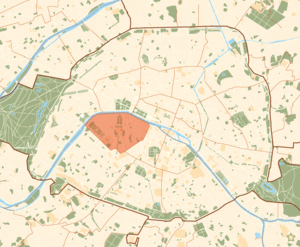
Geographical location
The 7th arrondissement is located directly on the Rive Gauche , the left bank of the Seine . It borders the 6th arrondissement to the east and is surrounded by the 15th arrondissement to the south and east . The 16th , 8th and 1st arrondissements are on the opposite bank of the Seine (from west to east) .
Quarter in the 7th arrondissement
The 7th arrondissement consists of the following four districts:
- Saint-Thomas-d'Aquin district
- Quarter of the Invalides
- Quartier de l'École Militaire
- Quartier du Gros-Caillou
According to the official census of the Parisian districts, these are quarters 25 to 28.
Demographic data
According to the 1999 census , 56,988 inhabitants are registered in the 408.8 hectare arrondissement. This corresponds to a population density of 13,933 inhabitants / km² and 2.7% of the total Parisian population.
Politics and administration
town hall

The town hall of the 7th arrondissement is located at rue de Grenelle 116, 75340 Cedex 07, phone: 01/53 58 75 07.
mayor
Rachida Dati (47), a member of the center-right UMP party , has been the mayor of the 7th arrondissement since 2008 .
Ministries
-
Assemblée Nationale ( National Assembly )
 Headquarters of the French Foreign Ministry, Quai d'Orsay
 - Ministère de la Défense (Ministry of Defense)
- Ministère de la Santé (Ministry of Health)
- Ministère de la Ville et Ammenagement du Territoire
- Ministère des Affaires Étrangères (Ministry of Foreign Affairs)
- Ministère des Affaires Européennes (Ministry of European Affairs)
- Ministère des Postes Télecommunications
- Ministère du Tourisme (Ministry of Tourism)
- Ministère de l'Éducation nationale (Ministry of Education)
- Ministère du Travail (Ministry of Labor)
- Minister of Transport
- Ministère de l'Agriculture (Ministry of Agriculture)

Attractions

See also: List of the monuments historiques in the 7th arrondissement (Paris)
- Ecole Militaire
-
Hôtel des Invalides
- Église du Dôme (Invalides Cathedral)
- Cathédrale Saint-Louis-des-Invalides
- Musée de l'Armée
- Hotel Matignon
- Musée d'Orsay
- Maillol Museum
- Rodin Museum
- Palais Bourbon (National Assembly)
- Parc du Champ de Mars
- Tour Eiffel
- Musée du quai Branly
Green areas
- Esplanade des Invalides
- Jardin Catherine Laboré
- Jardin de l'Intendant
- Parc du Champ de Mars
- Berges de la Seine riverside park (promenade ...)
Transport and infrastructure
Major roads


- Avenue Bosquet
- Avenue Charles Risler
- Avenue de Breteuil
- Avenue de la Motte Picquet
- Avenue de la Tour Maubourg
- Avenue de Lowendal
- Avenue de Saxe
- Avenue de Ségur
- Avenue de Souffren
- Avenue de Tourville
- Avenue de Villars
- Avenue du mal. Gallieni
- Avenue Duquesne
- Avenue Gustave Eiffel
- Avenue J. Bouvard
- Boulevard des Invalides
- Boulevard Raspail
- Boulevard Saint-Germain
- Quai Anatole France
- Quai Branly
- Quai d'Orsay
- Quai Voltaire
- Rue de Buenos Aires
- Rue de Grenelle
- Rue de l'Université
- Rue de Lille
- Rue de Sèvres
- Rue du Bac

Important places
- Place de Breteuil
- Place de Fontenoy
- Place de la Resistance
- Place des Invalides
- Place du Prést
- Place Vauban
Railway stations and metro lines
The metro stations Invalides , Duroc and Sévres Babylone are three important hubs in the arrondissement. Metro lines 8 , 10 , 12 and 13 pass through them .
The RER line C also stops at the Invalides and Musée d'Orsay stations and continues along the Seine (e.g. west to the Champ de Mars - Tour Eiffel station in the 16th arrondissement).
Important churches
- Chapelle Royale des Invalides (Invalides Cathedral)
- St. Louis des Invalides
- Ste-Clotilde
- St. François Xavier
- St. Thomas d'Aquin
Literary meaning
- Hannah Arendt : Essay Faubourg Saint-Germain , in: Elements and origins of total domination , pp. 149–155. Reprinted in: Essays by Famous Women. Edited by Marlis Gerhardt. Insel, Frankfurt 1997. ISBN 3-458-33641-9 . P. 54–71 (about this quarter, through the eyes of Marcel Proust's " Sodom and Gomorrah " in In Search of Lost Time . Another interpretation, Arendt following: Online )
Web links
- www.mairie7.paris.fr Official website of the arrondissement
- www.parisbalades.com ( Memento from April 1, 2016 in the Internet Archive ) Detailed description of the architecture
Individual evidence
- ^ Paul McQueen: A Brief History of the Faubourg Saint-Germain in Paris. Retrieved October 22, 2019 .
- ↑ Les 80 communes où se concentrent les plus hauts revenus . In: Capital.fr . August 22, 2013 ( capital.fr [accessed September 7, 2018]).
- ↑ Dans quelles communes paie-t-on le plus l'ISF? November 7, 2017. Retrieved August 17, 2019 .

1. (Louvre) | 2. (Bourse) | 3. (Temple) | 4. (Hôtel de Ville) | 5. (Panthéon) | 6. (Luxembourg) | 7. (Palais Bourbon) | 8. (Élysée) | 9. (Opéra) | 10. (Entrepôt) | 11. (Popincourt) | 12. (Reuilly) | 13. (Gobelins) | 14. (Observatoire) | 15. (Vaugirard) | 16. (Passy) | 17th (Batignolles-Monceaux) | 18. (Buttes-Montmartre) | 19. (Buttes-Chaumont) | 20. (Ménilmontant)