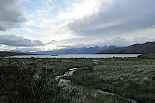
Lake Viedma
| Lake Viedma | ||
|---|---|---|

|
||
| Lago Viedma (center) and neighboring lakes | ||
| Geographical location | Santa Cruz , Argentina , South America | |
| Tributaries | Río Leona | |
| Drain | Santa Cruz River | |
| Places on the shore | Lake Viedma | |
| Location close to the shore | El Chalten | |
| Data | ||
| Coordinates | 49 ° 35 ′ S , 72 ° 30 ′ W | |
|
|
||
| Altitude above sea level | 250 m | |
| surface | 1 088 km² | |
|
particularities |
||
The Lago Viedma ( Viedma Lake ) is a 80 km long and 15 km wide glacial lake in the Argentine province of Santa Cruz near the border with Chile in the Los Glaciares National Park in the Andes . Its surface is 1,088 to 1,600 km² and its drainage goes to the Atlantic via Rio Santa Cruz.
geography
Lago Viedma is located in the Argentine Andes , which are included in Patagonia in these southern latitudes , near the Chilean border. There are several three-thousand-meter peaks in the area , such as the Cerro Fitz Roy (3,406 m), the Cerro Torre (3,128 m) and the Poincenot (3,076 m). El Chaltén is located at the foot of the Fitz Roy .
The most important glacier leading to Lake Viedma is the 575 km² Viedma Glacier , which is located in the west. The glacier water colors the lake turquoise blue. The Lago Viedma is connected to the southern glacial lake Lago Argentino . To the north is Lake San Martin .
history
Lago Viedma was discovered by the Spaniard Antonio de Viedma on his expedition in 1782 and named after him. There were further expeditions in the middle of the 19th century. The Los Glaciares National Park , which has existed since 1945, was declared a UNESCO World Heritage Site in 1981 .

