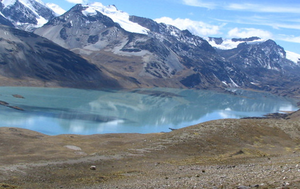
Laguna Suches
| Laguna Suches | ||
|---|---|---|

|
||
| View of the Laguna Suches | ||
| Geographical location |
|
|
| Drain | Río Suches | |
| Data | ||
| Coordinates | 14 ° 46 ′ 0 ″ S , 69 ° 16 ′ 0 ″ W | |
|
|
||
| Altitude above sea level | 4605 m | |
| surface | 14.2 km² | |
| length | 13.1 km | |
| width | up to 1.8 km | |
The Laguna Suches (also: Lago Suches ) is a lake on the border between the two South American Andean countries Bolivia and Peru , with around 90 percent of the area of the lake being assigned to the territory of Bolivia. The western bank of the lake belongs to the Peruvian region of Puno , the eastern bank to the Bolivian department of La Paz .
The Laguna Suches lies at an altitude of 4605 m surrounded by the ridges of the Cordillera Apolobamba . The lake is fed, among other things, by the Río Huaytire and Río Livicalane , it has an extension of thirteen kilometers in length and up to almost two kilometers in width, the total area of the lake is 14.2 km². The outflow of the lake at its southwestern end feeds the Río Suches , which has a length of 174 km and flows into Lake Titicaca near the Bolivian city of Escoma .
Web links
- Turismo ecológico: La Laguna de Suches en Tacna ( Spanish )
- Laguna de Suches (Spanish)
