Río Suches
| Río Suches | ||
|
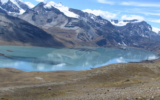
Laguna Suches , source lake of the Río Suches |
||
| Data | ||
| location |
|
|
| River system | Desaguadero River | |
| Drain over | Río Desaguadero → Lake Poopó | |
| origin | Lake Laguna Suches 14 ° 47 ′ 39 ″ S , 69 ° 20 ′ 21 ″ W |
|
| Source height | 4605 m | |
| muzzle |
Lake Titicaca Coordinates: 15 ° 41 ′ 38 ″ S , 69 ° 9 ′ 22 ″ W 15 ° 41 ′ 38 ″ S , 69 ° 9 ′ 22 ″ W. |
|
| Mouth height | 3810 m | |
| Height difference | 795 m | |
| Bottom slope | 4.6 ‰ | |
| length | 174 km | |
| Catchment area | 2822 km² | |
| Drain |
MQ |
11 m³ / s |
| Small towns | Escoma | |
| Communities | Villa Rosario de Wilacala | |
The Río Suches is an endorheic river to Lake Titicaca in the South American Andean highlands and in parts forms the border between the two states of Peru and Bolivia .
The Río Suches has a total length of 174 km. The river forms the outflow of the 4605 m high lake Laguna Suches on the southern flank of the Cordillera Carabaya , a mountain range of the Peruvian Eastern Cordillera . For the first 95 kilometers it runs along the border between Peru in the west and Bolivia in the east. The lower reaches lie within Bolivia. There he passes the village of Villa Rosario de Wilacala and the small town of Escoma . The Río Suches finally flows into the eastern part of Lake Titicaca near the Challapata peninsula ( Peninsula de Challapata ).
The Río Suches drains an area of 2822 km². The mean discharge is 11 m³ / s.
Web links
- Salinities and sediment transport in the Bolivian highlands (PDF; 682 kB) Journal of Hydrology 113 (1990) pp. 147–162 ( English )
- Continúa la horrorosa contaminacion del Río Suches March 17th, 2009 ( Spanish )
- Río Suches: Minería en la frontera Catapa April 9, 2010 ( Spanish )
