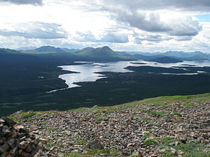
Lake Aleknagik
| Lake Aleknagik | ||
|---|---|---|

|
||
| View of the southeast end of the lake with the village of Aleknagik and the Wood River | ||
| Geographical location | Alaska ( USA ) | |
| Tributaries | Agulowak River , Sunshine Creek, Youth Creek | |
| Drain | Wood River | |
| Places on the shore | Aleknagik | |
| Location close to the shore | Dillingham | |
| Data | ||
| Coordinates | 59 ° 21 ′ N , 158 ° 49 ′ W | |
|
|
||
| Altitude above sea level | 10 m | |
| surface | 89.5 km² | |
| length | 32.5 km | |
| width | 3.5 km | |
| volume | 3324 million m³ | |
| scope | 77 km | |
| Middle deep | 37 m | |
| Catchment area | 2850 km² | |
The Lake Aleknagik is a 32 km long lake in southwest Alaska .
The lake is located in the eastern foothills of the Wood River Mountains , immediately south of Wood-Tikchik State Park . The village of Aleknagik is at its southeastern end .
The lake is fed by several mountain streams and the Agulowak River , which connects Lake Aleknagik with Lake Nerka to the north . The outflow is via the Wood River , which flows into the Nushagak River at Dillingham , which flows a little later into Bristol Bay , a bay in the Bering Sea .
Web links
Individual evidence
- ↑ a b c d Stacey J. Lowe, Steven Piazza, Patrick Walsh: Estimates of surface area and volume for 25 lakes, Togiak National Wildlife Refuge, southwestern Alaska (PDF, 2.8 MB) US Fish and Wildlife Service. January 2013. Retrieved December 22, 2017.
- ↑ USGS 15303000 WOOD R NR ALEKNAGIK AK
