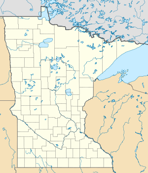
Lake Shetek
| Lake Shetek | ||
|---|---|---|

|
||
| Geographical location | Murray County , Minnesota , USA | |
| Drain | Des Moines River | |
| Places on the shore | The Lakes | |
| Data | ||
| Coordinates | 44 ° 7 ′ N , 95 ° 41 ′ W | |
|
|
||
| Altitude above sea level | 452 m | |
| surface | 14.55 km² | |
| scope | 51 km | |
| Maximum depth | 3 m | |
The Lake Shetek is the largest lake in the southwest of the State of Minnesota . It feeds the Des Moines River and is located in The Lakes settlement northwest of Currie in Murray County . The name Shetek is derived from the Ojibwe word for "pelican".
With few truly large lakes in southwest Minnesota, Lake Shetek is an important aquatic recreation area for the region. Lake Shetek State Park borders on its east bank .
geography
Lake Shetek covers an area of 1,455 hectares and is up to 3 meters deep. This rather moderate depth is typical of the Prairie Pothole region . The shore length is 51 kilometers.
Lake Shetek is by far the largest of the 100 or so lakes in Murray County. The second largest is Lake Sarah with an area of approximately 476 hectares. Previously, this role was taken by the Great Oasis Lake with around 593 hectares, which was drained at the beginning of the 20th century in order to gain land for agriculture.
The lake feeds the western arm of the Des Moines River. There are three larger islands in the lake: Valhalla, Keeley and Loon Island. These can be reached via footbridges from the bank. Shetek is also connected to Bloody Lake and Armstrong Lake.
geology
The formation of the lake is a result of the formation of glaciers. It originated around 15,000 years ago when the global climate warmed up due to the accumulation of sedimentary rock that blocked the drainage.
Problems
Since the lake is very shallow and many people are dependent on it, it has always been an important concern to maintain the water level even in the hot months. So a dam was built in the 1920s, and it was raised 0.46 meters in the 1930s. In 1966 and 1995 the dam was gradually expanded.
Humans also cause silting up in Lake Shetek . In 1973 a water level of 3.7 meters was measured at its lowest point, today it is only three meters. There is also a risk of excessive algae growth due to nutrient input from the surrounding farms and meadows.
Since the lake freezes over completely every seven years on average, fish deaths are increasing . Some fish populations, such as carp, recover better than most pulling fish, but these are important for recreational fishing .
swell
Individual evidence
- ↑ a b c d e f Hodgins, Nate. Status of the Fishery (as of 08/09/2010). Lake Information Report. Minnesota Department of Natural Resources. Retrieved March 13, 2012
- ↑ a b c d e game, Beth A. (2001), "Lake Shetek", in Amato, Anthony J .; Janet Timmerman; Joseph A. Amato, Draining the Great Oasis: An Environmental History of Murray County, Minnesota, Marshall, Minn .: Crossings Press, pp. 113-123
- ↑ Lake Shetek State Park. Minnesota Department of Natural Resources. Retrieved March 7, 2012
- ↑ Lake Shetek State Park signage. Minnesota Department of Natural Resources.
Literature and web links
- Lake Shetek State Park . Minnesota Department of Natural Resources. 2011-01. PDF file, accessed March 7, 2012
- Muchlinski, Jim (2001), "A Home Lake," in Amato, Anthony J .; Janet Timmerman; Joseph A. Amato, Draining the Great Oasis: An Environmental History of Murray County, Minnesota, Marshall, Minn .: Crossings Press, pp. 249-260
- Dahlin, Curtis A. (2009). The Dakota Uprising: A Pictorial History. Edina, Minn .: Beaver's Pond Press, Inc. ISBN 9781592982752 .
- Lake Shetek State Park. Rustic Style Resources in Minnesota State Parks. Minnesota Historical Society. Retrieved March 5, 2012
- Upham, Warren (2001). Minnesota Place Names: A Geographical Encyclopedia. St. Paul, Minn .: Minnesota Historical Society Press. ISBN 0-87351-396-7 .
- Lake Shetek in the United States Geological Survey's Geographic Names Information System
