
Long Anna


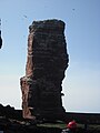
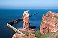
The Lange Anna ( Heligoland Frisian : Nathurn Stak ) is a 47 meter high pier in the extreme northwest of the German North Sea island of Helgoland . It weighs around 25,000 tons, is made of red sandstone and has an area of 180 m². Short Anna , which is connected to the Heligoland Oberland, around 50 meters further east, is less prominent and only formed on January 31, 1976 when a large piece of rock was broken off.
The Lange Anna is a popular destination for tourists and a landmark for Heligoland. Although the rock is not freely accessible, it can be viewed from above from the neighboring cliff end of the Oberland. Several species of seabirds breed on the rock , especially the guillemot , kittiwake and gannet .
history
Until May 16, 1860, the rock was part of a surf gate and was connected to the actual main island by a natural rock bridge, until this arch-like connection collapsed.
From 1903 to 1927 the Prussian Wall , a 1.3 kilometer long protective wall, was built along the west coast to keep the surf away from the rock base and thus stop further marine erosion (abrasion) on the west coast of Heligoland. The Lange Anna received its protective wall as part of the Lobster Claw Project , when a pier was built for a naval port.
The rock was climbed only once in October 1965. After that, climbing was banned. The very brittle Heligoland red sandstone also speaks against an ascent.
In 1969 the rock formation received the status of a natural monument .
In 1976, due to the partial demolition of the Oberland, another small, isolated rock was created in front of the Lange Anna, and the cliff edge path was relocated there due to further risk of collapse on the Nordhorn.
In 1979 a surf cave at the foot of the Lange Anna was walled up to prevent it from collapsing.
Further deterioration due to frost damage can hardly be stopped by technical means. According to an expert report by the Technical University of Harburg in 1998, the rock has deep crevices and cracks. The necessary measures to secure the Tall Anna would be enormous and could not stop the creeping weathering. Therefore, no further efforts are made. Due to the high susceptibility of a layer at a height of 16 meters, which consists of hangover sand and is already the thinnest part of the Long Anna, there is an acute risk of the upper two thirds of it breaking off.
Naming
The name of the rock is in Heligoland Frisian Nathurn Stak : "Nordhorn-Surfpfeiler". Different names were and are used for the rock, as the picture gallery below shows. First of all, illustrations were signed based on the Heligoland name with "Nordspitze" or "Nordcap". In a German national travel guide from 1901, the rock is called "Schildwache". The name "stallion" was also used in numerous travel guides, but it was borne by a different rock, which collapsed in 1856, also at the northern tip, but at another point and disappeared completely.
The name “Mönch” is usually based on a confusion with the similar rock “Mönch”, which stood on the southern tip until it was blown up in 1947. However, like the “stallion”, this term can also be used as a generic term. In addition to the older and originally better known rock "Mönch", there is also the name "Nun" for Lange Anna. The name "Lange Anna" was created around 1900, about the origin of which there is only speculation, although reference has been made to the beautiful waitresses since the turn of the last millennium. "Lange Anna" comes from the German popular humor before the First World War, similar to Big Bertha - this is how a cannon was called during the First World War and the lighthouse Big Berta in Cuxhaven before the First World War ; there was also a slim Anna from the same period. Else Lasker-Schüler , for example, can call “Lange Anna” a working-class transvestite in her drama Die Wupper from 1909. The joke was related to physical traits and was not intended to rule out sexual associations.
With this joke name, the height of the rock is viewed with mockery and respect. The neighboring Pinneberg , the summit of which is the highest point on the island, owes its name to a similar sense of humor. In the brochures of the spa administration, the name only appears in brackets in the three editions before the First World War, and regularly only from the 1960s onwards. The NSDAP Helgoland, in which biologists and teachers from the mainland were leading, tried in 1934 with the title of their newspaper Nathurn to create a closeness to the Heligoland, the name "Lange Anna" was considered disrespectful among the Helgoland. In her language, in Heligolandisch , Lange Anna is still called Nathurn today. Since the joke of the name is no longer understood, the story of the long waitress Anna has been used to explain the name.

Reprinted in 1890 in the gazebo from the coastal drives of 1881. This drawing by Gustav Schönleber , originally only entitled “Helgoland”, was also given the name “Nordspitze” in reprints .

The "monk" (photo by Wilhelm Dreesen ; 1895)

West coast with "nun" and fog station around 1910

Photochromic print of the "stallion" at the northern tip of Heligoland (between 1890 and 1905, photographer unknown)

The "Sentinel" in temptation; German national postcard before the First World War by Fritz Hass

Long Anna; Looking North (2010)
Lange Anna vom Nordwattboden (2011)
Long Anna (2015)
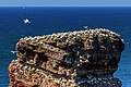
Northern gannet colony at the top of the Lange Anna (2016)
_b_469.jpg)


Individual evidence
- ↑ Chronicle of Helgoland (private website)
- ↑ Brohm (Major): Helgoland in history and legend. His demonstrable land losses and his experiences. Cuxhaven, Helgoland, Rauschenplat, 1907
- ^ Pit Schubert : Anecdotes from the mountain: Amusing stories from mountaineering, climbing and skiing , Bergverlag Rother, 2010, ISBN 3-7633-7039-0 .
- ↑ Schindler, Johannes; Lindemann, Hubert - Construction and repair of communal port and shore facilities on the island of Helgoland since 1952, in: The Coast - Heft 49 (1990) [1]
- ↑ Rescue of Tall Anna on Helgoland , in projects , accessed on September 17, 2019, on Umweltstiftung.allianz.de
- ↑ Axel Bojanowski : The wavering Anna. sueddeutsche.de from May 17, 2010, accessed on March 3, 2017
- ↑ Maren Lindstaedt, Thomas Kersten: A virtual clone for Helgoland's Long Anna through terrestrial laser scanning. , in: Thomas Luhmann (Ed.): Photogrammetrie, Laserscanning, Optical 3D-Messtechnik - Contributions of the 4th Oldenburg 3D-Tage 2005. Wichmann-Verlag, Heidelberg, ISBN 978-3-87907-420-4 , p. 216– 223.
- ↑ Helgoland - A travel sketch. Woerl's travel manuals, 2nd edition, Leipzig 1901.
- ^ Sigrid Bauschinger : Else Lasker-Schüler. Biography. Wallstein, Göttingen 2004, ISBN 3-89244-440-4 . See also the origin of the name in the article Strammer Max shortly after the First World War or the multiple use of the name Langer Heinrich .
- ^ Eckhard Wallmann: A colony becomes German - Heligoland between the world wars . Bredstedt 2012.
Web links
Coordinates: 54 ° 11 ′ 17 ″ N , 7 ° 52 ′ 10 ″ E