
Langenberg (Bad Iburg)
| Langenberg | ||
|---|---|---|
.jpg&filetimestamp=20080612220920&) Historical postcard (1906): Langenberg from the east with the Sander limestone quarry and the mill pond of the Schlossmühle (today's Charlottensee) |
||
| height | 206 m above sea level NHN | |
| location | Bad Iburg | |
| Mountains | Teutoburg Forest | |
| Coordinates | 52 ° 9 '28 " N , 8 ° 1' 55" E | |
|
||
| rock | limestone | |
| particularities | Mining in the 19th and 20th centuries | |

The Langenberg (occasionally also: Langer Berg ) is a 206 meter high mountain in the city of Bad Iburg (Lower Saxony). A small section of the mountain in the north-west is in Holperdorp, which belongs to Lienen and thus North Rhine-Westphalia.
location
The Langenberg belongs to the 1st Teutoburg Forest Ridge , which also includes the Kahle Berg and the Freeden (269 meters) in the Bad Iburgs area .
The Langenberg lies west of the Charlottensee and the Iburger Schloss . To the north is the 213 meter high Urberg . On the north side of Langenberg, Holperdorper Straße, part of Kreisstraße 332, leads from Charlottenburger Ring west towards Holperdorp. The Langenberg is largely densely forested, predominantly with beech forest, occasionally with coniferous forest. From Holperdorper Straße the Jägersteig leads as a zigzag path to the Langenberg. The Jägersteig overcomes a height difference of around 45 meters. A ridge path leads over the Langenberg.
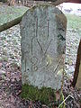
On the ridge path of the mountain there is a stone with the insignia of the abbot of the former Iburger Benedictine monastery . At the foot of the Langenberg below the Jägersteig is the boundary stone IV from 1827, which marked the border between the Kingdom of Hanover and Prussia.

Stone with the insignia of the abbot of Iburg Abbey
Boundary stone of the Kingdom of Hanover to Prussia from 1827


Mining

The Langenberg is made of limestone . On the mountain, as on the Iburger Hagenberg, limestone was mined, which from 1872 was burned in the Kokesche lime kiln in the east of the Langenberg. Conrad Sander, a merchant, took over the lime works, which was within sight of the mill pond and later Charlottensee. The lime works was closed around 1904; the lime kiln demolished in the 1950s. In the southern area of the Langenberg there were several smaller limestone quarries that belonged to Iburger farms such as Hülsmann, Metker, Tobergte and Tönniges. The stone mined there was mainly used for personal use and for road construction.
literature
- Horst Grebing: Extraction and use of mineral resources in the area of today's city Bad Iburg (= Iburger Hefte. 1, ZDB -ID 2196545-6 ). Association for local and local history Bad Iburg, Bad Iburg 2002, pp. 10–13.