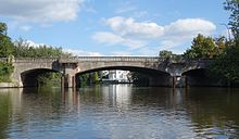
Langenzugbrücke
The Langenzugbrücke crosses the lake called Langer Zug at the mouth of the Osterbek near the Alster . The Lange Zug is a side bay of the Outer Alster and was formed by the confluence of the Osterbek into the Alster. The bridge connects the Hamburg districts of Uhlenhorst and Winterhude .
Location and traffic load
With the crossing of the Langenzugbrücke, the Winterhuder Sierichstrasse changes its name and turns on the Uhlenhorster side into the Herbert-Weichmann-Strasse, which is named after the SPD politician Herbert Weichmann , who held the office of First Mayor from 1965 to 1971 .
The bridge was used by an average of 15,000 vehicles per working day in 2013, around 3 percent of which were heavy traffic.
construction
The Langenzugbrücke is an arched bridge with two columns, over which there are balconies with z. T. decorated bridge railings are. Below the balconies are tiled, empty niches. It is a concrete bridge that is clad with shell limestone and thus looks like a stone bridge. It is 40 meters long and has three passages, of which the middle one is 18 meters wide and was intended for steamship traffic . The foundations for the guard's lodge, steps and the walkways for landing passengers can still be seen on the central pillars.
monument
The Langenzugbrücke was built between 1909 and 1911 and replaced an iron bridge over the Long Zug at this point . This older Langenzugbrücke was the first large iron bridge to be built in Hamburg in 1864. Today's Langenzugbrücke was one of the first concrete bridges in Hamburg. It is listed with the number 21684 as a monument in the list of monuments of the Hamburg cultural authority .
Notes and individual references
- ^ Horst Beckershaus: "Die Hamburger Brücken" , Convent Verlag, Hamburg 2007, ISBN 978-3-86633-007-8 , page 65
- ↑ Map of the average daily vehicle traffic volume on working days (Monday – Friday), Hamburg 2013 (PDF file; 5.3 MB)
- ^ Sven Bardua: "Bridge metropolis Hamburg Baukunst Technik Geschichte bis 1945 ", Dölling and Galitz Verlag, Munich and Hamburg 2009, ISBN 978-3-937904-88-7 , page 73
- ^ Sven Bardua: "Bridge metropolis Hamburg Baukunst Technik Geschichte bis 1945 ", Dölling and Galitz Verlag, Munich and Hamburg 2009, ISBN 978-3-937904-88-7 , page 92
Web links
- List of monuments of the Hamburg cultural authority (PDF file; 10.7 MB), accessed on March 19, 2017
Coordinates: 53 ° 34 ′ 38.8 " N , 10 ° 0 ′ 36.1" E
